The first batch geonews edition!
On the open source / open data front:
- An informative update on the OGR OpenFileGDB driver to read Esri's file geodatabase format
- Plugin to display QGIS 2D maps in 3D in a web browser via three.js
- Interesting predictions and trends, Juan Marin’s Predictions for and Paul Ramsey’s Predictions for and MapBrief Geo Predictions
- We never mentioned the open source data portal software before, but it supports geospatial data pretty well
- Via OR, MapGive — U.S. State Dept launches OpenStreetMap contributing tool “to help humanitarian efforts”, and the State of the Map will be held in Buenos Aires
- Some software updates, MapGuide Maestro 5.1, Geopaparazzi 3.9.0 is out, SAGA 2.1.1 released, Mapbox.js v1.6.0
- Using open source software to answer Will the sun shine on us?
- Talking of the sun, News from Marble: Introducing Sun and the Moon and Planets
On the Google front:
- Really worth taking a look to Climate Viewer 3D: The Google Earth Climate Change, Pollution and Privacy Viewer
- A new book, Google Maps JavaScript API CookBook
- Viewing the Topography of the Thermohaline Circulation of the Oceans in Google Earth
- There's New 3D imagery in Tokyo and other Japanese cities
- From Slashdot. Google Removes "Search Nearby" Function From Updated Google Maps
- Why not, Creating artwork based on Street View
- If genealogy is within your interests, Genealogy through Google Earth
On the Apple front:
- Description of an Apple Maps App with Interactive Data Layers Detailed in New Patent
- Will this concept catch up? Apple's iBeacon Technology Brings New Possibilities for Location-Based Gaming
- Nokia's HERE not popular enough? Nokia Pulls 'HERE' Maps App for iOS, Citing iOS 7 Changes That 'Harm the User Experience'
Discussed over Slashdot:
- Yes, this is coming, Swarms of Small Satellites Set To Deliver Close To Real-Time Imagery of Earth another related entry is named Planet Labs to capture near-continuous whole-Earth imagery from 28 five kilogram satellites
- If you're a regular Slashgeo reader, you know this already, Why the World Needs OpenStreetMap, and it's time to migrate 'en masse' according to The Guardian
- On privacy, It's Not Just the NSA: Police Are Tracking Your Car
- But you know what? Carmakers Keep Data On Drivers' Locations From Navigation Systems
- And here's a confirmation, Ford Exec: 'We Know Everyone Who Breaks the Law' Thanks To Our GPS In Your Car
- But there's always hope? Recent Federal Trade Commission (FTC) Settlement Will Make It Harder to Collect and Share Geoinformation In US
- First step before commercial drones, Feds Announce Test Sites For Drone Aircraft
- For fun, CES: Building Self-Guiding Lego Robots for Fun and (Maybe) Profit (Video)
- There are still wonders to discover, thanks to geo, Lasers Unearth Lost 'Agropolis' of New England
- Tracking bees, Scientists Glue Sensors To 5,000 Bees In a Bid To Better Understand Them
In the everything else category:
- A geodesy dream? Affordable Arduino-Compatible Centimeter-Level GPS Accuracy
- Using LIDAR data? Read Format Wars Episode V: LIDAR, why? Esri Launches its Own Propriety Compressed LiDAR Format: .zlas
- An article on Spike, creating 3D models of buildings and things with a smartphone, not the first app of that kind but that one comes from a GIS company
- Free map online course from Coursera to begin in April
- You already know what IFTTT recipes are? Here's you'll learn about geoenabling triggers with geofences and more
- Here's about SenseFly, a drone for taking oblique imagery
- A generic entry on the Cocktail of Technologies for Smart Cities: The role of Geospatial Tech
- Wired on Tracking the Secret Lives of Great White Sharks
- Let's talk about our privacy again, DARPA’s 1.8 gigapixel ARGUS-IS: The Ultimate Surveillance System from above?, that's 1.8 gigapixels and 12 frames/second, 24/7
- On the SPOT remote sensing satellite family, up to SPOT 7, The new SPOTs
- On 3D printing, yup, really mainstream now, Adobe Adds 3D Printer Support To Photoshop and here's about the open source ' slic3r ' — converts a digital 3D model into printing instructions for your 3D printer (via OR)
In the maps category:
- On mapmaking, The Hidden Meanings of Maps: Design and Colors
- Beautiful, A woodcut inspired map for city streets
- Jonathan provides a book Review: A History of the World in Twelve Maps
- And here's A look at twelve maps that changed the world
- Don't we all like beautiful maps? Wired shares The Most Amazing, Beautiful and Viral Maps of Year
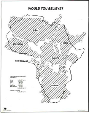
- Here's a map you have to see, would you believe how big is Africa? Mercator projections are messing with our perception of the world
