Augmented and virtual reality are pertinent to geospatial at least for the part where it allows to visualize 3D content and furthermore visualize this content in a location-based context. That’s why I’m sharing with you the news of Microsoft Goggles named Project HoloLens (also discussed over Slashdot). They’re not the first ones of course, with Google Glass and Oculus Rift ...
Read More »Alex
ThinkGeo Updates Map Suite GIS Editor
Frisco, TX — ThinkGeo has updated their Map Suite GIS Editor application, designed for Geographic Information System professionals. The upgrade includes a number of new features, bug fixes, and stability improvements. This is a major product update and the most significant update since the product was first released. The latest release includes the latest Map Suite World Map Kit Online base-map ...
Read More »Q&A with OpenStreetMap’s Founder Steve Coast
In December we mentioned the now-successful crowdfunding initiative for The Book of OpenStreetMap, to be written by Steve Coast, the founder of OpenStreetMap. During the Holiday Break, Steve Coast participated to a live reddit “Ask Me Anything” session on OpenStreetMap, and there’s a lot of pretty interesting discussion in there. And Steve did answer my own question Here’s some snippets: ...
Read More »Getmapping Introduces Multiple Enhancements to its Online GIS
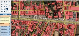
Getmapping has released version 6 of its highly successful multi-featured Online GIS. The new version has been enhanced with support for Worldwide projections, a module for publishing INSPIRE-compliant WMS/WFS and a new module for Getmapping’s panoramic imagery product, Street Layer. Getmapping’s Online GIS, together with its associated ‘Cloud’ storage and built in national mapping layers, allows organisations to share information ...
Read More »GIS Cloud releases official Partners Program
GIS Cloud is opening by taking the “Simple GIS” idea even further and announcing the release of its Partners Program. The company is looking for partners worldwide that are ready to resell, integrate and customize GIS Cloud into their local markets and industries. Register for a free webinar on Wednesday, January 21st, where the Partners Program will be discussed ...
Read More »The Best NYC Maps
In my view, digital maps are the most interesting and insightful content form being created today. Done well, a single map can convey complex stories that cannot be expressed with language, while at the same time being aesthetically as beautiful as any piece of art. This is a piece we put together to recognize some of the great maps, and mappers, coming ...
Read More »International Map Year
Maps are at the core of geospatial, and we’re now into the International Map Year. From the official website: “The International Cartographic Association has decided to celebrate an International Map Year during the years of and and has also formed a working group to plan and organise that task. […] The ICA expects that all ICA member ...
Read More »Digital Data Services, Inc. Awarded Contract with Pitkin County, Colorado
Digital Data Services, Inc. Awarded Contract with Pitkin County, Colorado January 15th, Lakewood, CO- Digital Data Services, Inc. (DDS) announced that it was awarded a contract with Pitkin County, Colorado to support a web-based customer portal. Under the contract, DDS will design an online map application that allows for feature creation services for GIS products including mailing ...
Read More »Turn Your Android into a Mobile Data Logger for Mapping and GIS Systems
AgTerra Updates MapItFast, and Android Based GIS Mapping Tool GATHER FIELD DATA and INFORMATION for GIS SYSTEMS QUICKLY and EASILY People working in the field are the best source for gathering GIS map related data, but your workers need to focus on the job, not the technology. MapItFast is the way to simplify field mapping and data gathering with a single tap ...
Read More »Turf: New Open Source WebGIS
We begin year with pretty interesting and major news. WebGIS is one giant step closer to be seriously useful, thanks to the new open source WebGIS project named Turf. From the MapBox announcement: “Turf is GIS for web maps. It’s a fast, compact, and open-source JavaScript library that implements the most common geospatial operations: buffering, contouring, triangular irregular networks ...
Read More »