Supergeo Technologies, the leading global provider of complete GIS software and solutions, releases updated SuperGIS Desktop 3.2, which supports Lidar data and adds more analysis tools. SuperGIS Desktop 3.2 integrates abundant GIS tools to offer users from various domains a professional platform for geoprocessing, analyzing, displaying, editing, managing, and querying spatial data even faster and more easily. The ...
Read More »Tag Archives: GIS software
GIS Global Purchases SuperPad to Empower Survey Solutions
Supergeo Technologies, the leading global provider of complete GIS software and solutions, announced that GIS Global, Indonesia purchases SuperPad 3.1a through PT. Datascrip, Supergeo’s partner. The mobile GIS solution is to facilitate their customers with powerful GIS data collection application, which empowers surveying data collecting and management. GIS Global runs an online shop for GIS surveying equipments, including total ...
Read More »SuperSurv 3.2 Supports iOS 8 and Enhances GPS Display
SuperSurv (iOS) 3.2, the field data collecting app for iPhone and iPad users, now fully supports iOS 8 and enhances GPS display with optimal user experiences. Developed by Supergeo, SuperSurv is an efficient mobile GIS app for field data collection on iOS and Android platforms. Integrating with GIS and GPS technologies, SuperSurv provides functions like Map Display, Query, Measure, ...
Read More »SuperGIS is Selected for Public Infrastructure in Nepal
Supergeo Technologies, the global leading GIS software and solution provider, announces that Rajdevi Engineering Consultant utilizes SuperGIS Desktop, SuperGIS Spatial Analyst and SuperGIS 3D Analyst in several governmental public infrastructure projects in Nepal. Located in Kathmandu, Rajdevi Engineering Consultant, a partner of SATPALDA Geospatial Services, India, was selected by Nepal government to work on several public infrastructures in the conutry. ...
Read More »Tag at Hot Tourist Spots with GIS
Tourism management is highly relevant with locations, so GIS is useful to find out better solutions. However, traditional research consumes a lot of time on data collecting, and is limited to sample amounts. With modern technologies, photos can be taken with coordinate info, and GIS can help researchers effectively analyze tourist hot spots in an easy-to-understand way. Researchers gather ...
Read More »Supergeo Launches the Newest SuperGIS Network Analyst 3.2
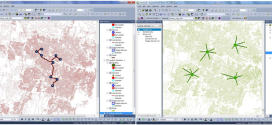
Supergeo Technologies Inc., the global leading GIS software and solution provider, launches the newest SuperGIS Network Analyst 3.2 with stronger analysis performance and computing methods. SuperGIS Network Analyst 3.2 enables users to analyze routing problems in multiple applications, such as transportation planning, tourism shortest analyst, underground pipelines planning, convenience store location deciding, service distribution etc. Through the analysis program, users ...
Read More »SuperGIS Assists Talented Youth in Winning Geography Olympiad Champion
Supergeo Technologies, the global leading GIS software and solution provider, announce that SuperGIS was chosen in Taiwan Geographic Olympiad and helped the participants win the first award. The winners would have a chance to represent Taiwan for joining iGeo, International Geography Olympiad. Taiwan Geography Olympiad provides nationwide youths with a stage to show their geographic knowledge combining with practical ...
Read More »Supergeo Awards Reseller of the Year to Helix S.r.l., Italy
Supergeo Technologies, the global leading GIS software and solution provider, announce that Helix S.r.l., Italy is awarded as Supergeo Reseller of the Year for their contribution to creating important client base and brand awareness in the EU. The two companies started to collaborate in when Helix S.r.l. firstly developed mobile GIS program for civil services by SuperGIS Mobile ...
Read More »GIS Reappear Historical Township Maps
To better understand historical geospatial relations and complete the shortage of traditional historiography, which usually only uses textual materials, GIS technologies provide historians with modern method to rebuild the historical township. With SuperGIS Desktop 3.2, historians may firstly rectify the historical Qing-Dynasty map, so the old image can be located with current coordinate information. Then, satellite image and digital map ...
Read More »Latest SuperSurv 3.2 Boosts Convenience of Geospatial Data Collection
Developed by Supergeo, the latest version of SuperSurv (iOS/Android) 3.2 is upgraded with more global coordinates systems functions to bring users a more convenient and intuitive manipulation. SuperSurv, the mobile GIS app, is designed for field survey on iOS and Android platforms. Integrating with GIS and GPS technologies, SuperSurv enables users to display map, query features, measure length and area, ...
Read More »