pygeometa is a new open source Python package to generate metadata for geospatial datasets. Users can manage simple configurations to generate geospatial metadata in a variety of formats. Features: simple configuration: inspired by Python’s ConfigParser extensible: template architecture allows for easy addition of new metadata formats flexible: use as a command-line tool or integrate as a library pygeometa is available ...
Read More »Tag Archives: standards
New Scientific Journal: Open Geospatial Data, Software and Standards
Thanks to Between the Poles I learned about the new SpringerOpen journal named ‘Open Geospatial Data, Software and Standards’. Its content is published under a Creative Commons license (CC-BY). The aims and scope: “Open Geospatial Data, Software and Standards provides an advanced forum for the science and technology of open data, crowdsourced information, and sensor web through the publication of reviews ...
Read More »pycsw Graduates OSGeo Incubation
OSGeo is pleased to announce that the pycsw project has graduated from incubation and is now a full fledged OSGeo project. Angelos Tzotsos, a long time member of the pycsw Project Steering Committee (PSC) has been appointed as project officer. The full post is available on the OSGeo website. The project powers numerous high profile activities such as US data/geoplatform, ...
Read More »Batch Geonews: QField, IndoorGML Standard, Focus on Google Maps for Work, 30m SRTM-DEM, and much more
The first batch-mode edition of the geonews. On the open source / open data front: There’s a new free course Introduction to Geospatial Technology Using QGIS (from Feb 23 - Mar 29) which also has content on GitHub Beautiful and simple, How to: watercolor pastel style in QGIS Announced is the FOSS4G-Europe conference, this time in Como, Italy, ...
Read More »The Shapefile Problem and Potential Solutions
Here’s an excellent article on the problems of the Shapefile format and contenders as replacements of this omnipresent format. We mentioned the shapefile format frequently in the past, and while I was/am excited about the GeoPackage format and standard (I work in a world where OGC standards matter), James Fee concludes by anticipating that ‘the shapefile will outlive us all’. ...
Read More »OGC honored Jacobs University Professor Peter Baumann with Kenneth D. Gardels Award
Peter Baumann, Professor of Computer Science at Jacobs University, has been honored with the Kenneth D. Gardels Award by the Open Geospatial Consortium (OGC). The OGC Board of Directors awarded the prize to Peter Baumann in recognition of his “significant contribution to the OGC’s essential role and mission in the global Information Technology community”. Jeffrey K. Harris, Chairman of the ...
Read More »Batch Geonews: Book of OpenLayers 3, 30m Worldwide DEM, U.N. Guide to GeoStandards, and much more
Here’s the recent geonews in batch mode, covering most of September up to today. On the open source / open data front: It’s there now, announcing the release of The Book of OpenLayers 3 Be ready, within a year we’ll have all SRTM-DEM Level-2 (30m) data for the whole world, NGA Releases Hi-Res Elevation Data Here’s the Heron Mapping Client, ...
Read More »Big Science Data Coming to SQL Databases
Bremen, June 17 – Multi-dimensional sensor, image, simulation output, and statistics data make up for most of the “Big Data” in science and engineering. Last week, it has been decided to extend the SQL database language with massive multi-dimensional arrays. Initiated by Prof. Peter Baumann from Jacobs University, work has commenced on the forthcoming standard named SQL/MDA. SQL has been ...
Read More »Batch Geonews: GeoPackage Webinar, Esri and Open Data, Future of Google Earth, OpenLayers 3 News, QGIS 2.2, and much more
Here's the recent geonews in batch mode. I've been struggling with many fires, I currently publish much less frequently than usual, but don't worry, everything major is in there!
From the open source / open data front:
- Dubbed as the Shapefile replacement, we discussed the GeoPackage standard several times, next week March 5 there's a webinar about it
- Certainly useful, GitHub adds visual history for maps, visualizing geojson updates directly on a map
- In case you missed the press release, open source 3D city platform ViziCities released on GitHub
- The power of open data, At Sochi Olympics, Crowdsourced OpenStreetMap Trounces Google Maps
- And if you wonder, Sochi was not mapped for Olympics and look at the nice maps you can do with open data - Sochi, with love
- News of OpenLayers 3 currently in beta 2, OpenLayers 3 Is Coming, Creating a custom build of OpenLayers 3 and there's even The book of OpenLayers3 is coming
- Using MapServer on Windows? Announcing MapServer MapManager 1.0
- In other updates, what's new in QGIS 2.2 which by itself could have deserved it's own entry, GeoTools 10.5 released and Rasterio 0.6
- Interesting entry on PostGIS bugs
From the Esri front:
- An article from readwrite, Esri Enables Federal Agencies To Open GIS Mapping Data To The Public
- We mentioned it last November, Introducing Esri’s Geotrigger Service: Welcome to the Future of Geofencing
- There's CityEngine key new features
- And What’s coming in ArcGIS Online March
- APB also offer Top 10 Take-Aways from the Opening Plenary of Esri’s Federal GIS Conference
From the Google front:
- Here's a very interesting article from Frank Taylor on the future of Google Earth, which apparently is being left aside in favor of Google Maps
- Google is Introducing Google Maps Gallery: Unlocking the World’s Maps
- The Canadian north in Street View, Wandering in the footsteps of the polar bear with Google Maps
- And it goes to India too, Discover the Taj Mahal and other iconic Indian monuments on Street View
- And a frequent topic, Monitoring the World's Forests with Global Forest Watch
- And if you don't like OpenStreetMap and open data, Expanding Google's Map Maker community in Southern and Eastern Europe
- A book review, Google Maps JavaScript API Cookbook
- Pretty nice and useful, Visualizing Google Search Results overlaid over 3D buildings
Discussed over Slashdot:
- DIY, Radar Expert Explains How To Cheaply Add Radar To Your Own Hardware Projects
- Video, not just photo anymore, New 360-Degree Video Capture Method Unveiled
- After autonomous cars, Terrafugia Wants Their Flying Car To Be Autonomous
- Don't tell me you're surprised, Lumia Phones Leaking Private Data To Microsoft
- That's not fun for their users, Major Vulnerability In Tinder Dating App Allowed User [ Location ] Tracking
- Cellphone tracking, Death By Metadata: The NSA's Secret Role In the US Drone Strike Program
- And some of the time there's hope, ICE License-Plate Tracking Plan Withdrawn Amid Outcry About Privacy
- And there's the good uses, A New Use For Drones: Traffic Scouting
- Not surprising, Australian Police Deploy 3D Crime Scene Scanner
- A New Interactive Map For Understanding Global Flood Risks and here's a related article
- It's not going well for our oceans, 3D Maps Reveal a Lead-Laced Ocean
- It's actually from DigitalGlobe, Google Earth's New Satellites
- Car navigation, Dead Reckoning For Your Car Eliminates GPS Dead Zones
- And cars will chat together, Government To Require Vehicle-to-vehicle Communication
In the everything-else category:
- Interested in Lidar? Read LIDAR Format Wars: Towards an Open Future and it matters, Report predicts that low cost LiDAR will be disruptive in next 5 years, also related, LiDAR Data Quality Standards, Certification Discussed at LiDAR Forum Session
- Here's a list of Free GIS Apps on the Google Play Store
- Earlier this month, the 'father of GIS, Roger Tomlinson, passed away
- It has been a while since we discussed The State of CAD and GIS Integration
- A new article on What Skills Does A GIS Analyst Require
- An anniversary this month, Celebrating 25 Years of Not Getting Lost Thanks to GPS
- Groups on Earth Observations? What is GEO
- Microsoft, 15 New 3D Cities Available in the Bing Maps Preview App
- Law, California Appeals Court Rules State Law Doesn't Prohibit Driver Use of Smartphone Maps
- VIa OR, Mapping Twitter Topic Networks: From Polarized Crowds to Community Clusters
- Via OR, after iBeacons and many others, here's the Nokia Treasure Tag
- OGC news, OGC Activities and Mobile Industry Trends and the Candidate OGC IndoorGML standard available for public comment
- Amazing what you can do for fantasy locations, If Middle-Earth Were Real, These Exquisite Shots Would Be Its Vacation Brochure
- Here's a fake mapped town that became real, Agloe, the Paper Town Stronger than Fiction
- New online courses, New Geo MOOC: From GPS and Google Maps to Spatial Computing
In the maps category:
- Over Canadian national news website, there was a mention of the map of legal cannabis in the U.S.
- Syria over Wired, Hyperlocal Neighborhood Maps Reveal the Chaos in Aleppo
- Nice map, A Map of U.S. Intercity Bus and Train Routes
- The First online Global Freshwater Biodiversity Atlas
And thanks to Andrew Zolnai for his recent donation to Slashgeo, we wouldn't be there without the community!
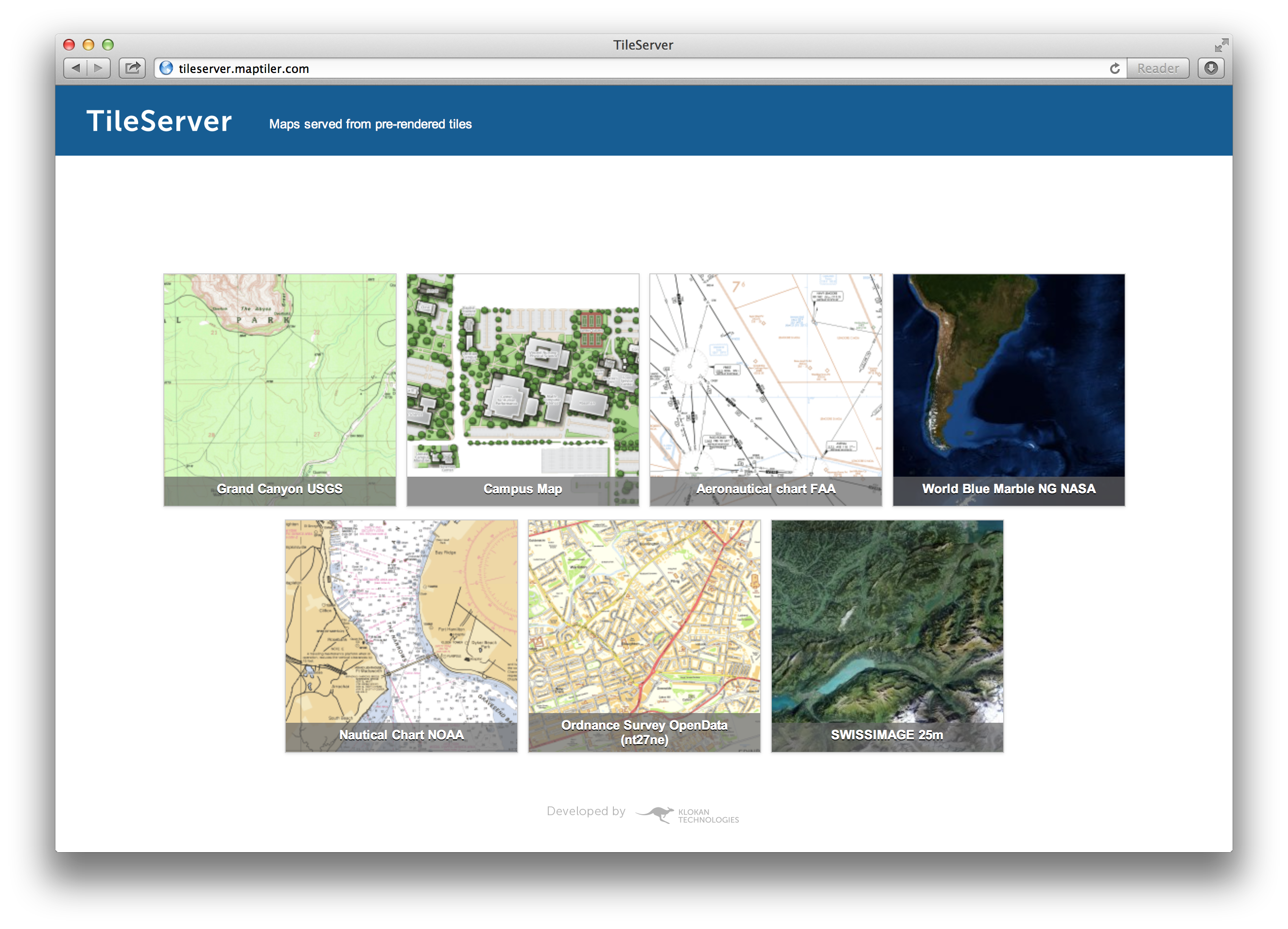
Read More »TileServer-PHP: OGC Web Map Tiling Server (WMTS)
While we mentioned several times the WMTS OGC standard and its brother the TMS protocol, we never mentioned TileServer-PHP, an open source Web Map Tiling Server.
From the github readme: "This server distributes maps to desktop, web, and mobile applications from a standard Apache+PHP web hosting. It is a free and open-source project implementing OGC WMTS standard for pre-rendered map tiles made with MapTiler Cluster, MapTiler, GDAL2Tiles, or available as MBTiles files. It is the easiest and cheapest way how to serve zoomable maps in a standardized way - practically from any ordinary web hosting. It is easy to install - just copy the project files to a PHP-enabled directory along with your map data containing metadata.json file. It comes with an online interface showing the list of the maps and step-by-step guides for desktop GIS software [...]"
Also important, supported protocols are:
- OpenGIS WMTS 1.0.0
- OSGeo TMS 1.0.0
- TileJSON.js
- Direct access with XYZ tile requests (to existing tiles in a directory or to .mbtiles)