Tag Archives: Street View

Google Announces Much Improved 3D Models for Google Earth, Offline Maps for Android, 12 New Map Maker Countries, and more

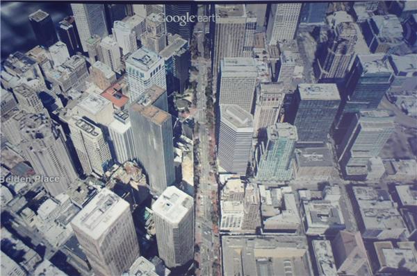
Today Google announced a few major upcoming features to their map-related products, including much improved 3D models for Google Earth and offline maps for Android.

From APB and the official Google blog :

  • On the 3D models: "today we are excited to announce that we will begin adding 3D models to entire metropolitan areas to Google Earth on mobile devices." [...] "[...] advanced automated 3D model creation from imagery. He noted it’s not new, but it far better than what came before. It uses stereo photogrammetry from many well overlapping images. [...] Google is contracting planes to collect the imagery." [...] "By the end of the year we aim to have 3D coverage for metropolitan areas with a combined population of 300 million people."
  • On Android offline maps: "So today we’re announcing that offline Google Maps for Android are coming in the next few weeks. Users will be able to take maps offline from more than 100 countries. This means that the next time you are on the subway, or don’t have a data connection, you can still use our maps."
  • They also announced Street View Trekker: "There’s a whole wilderness out there that is only accessible by foot. Trekker solves that problem by enabling us to photograph beautiful places such as the Grand Canyon so anyone can explore them. All the equipment fits in this one backpack [...]"
  • Map Maker is coming to several new countries (too bad for my hopes of seeing Google move to OpenStreetMap data ;-): "Today we’re announcing the expansion of Map Maker to South Africa and Egypt, and to 10 more countries in the next few weeks: Australia, Austria, Belgium, Denmark, Finland, Liechtenstein, Luxembourg, New Zealand, Norway and Switzerland."

If you want to see screenshots of the event, CNET has plenty of them.
 

Read More »

Google Geonews: Indoor Directions for Android, Spreadsheet Mapper 3, Google Earth Builder Renamed Google Maps Engine, and much more

Catching up geonews, here's the recent Google-related geonews.

From official sources:

  • The latest Google Maps 6.7 for Android introduces Google Offers and Indoor walking directions
  • We mentioned Speadsheet Mapper in, and now Spreadsheet Mapper 3 is available, in short, "Spreadsheet Mapper is a tool that enables anyone to easily create a well-designed  KML file  to show off their data in Google Earth and Maps"
  • The Baltic nations of Estonia and Latvia are now in Street View
  • Here's the 'Model your Town' winner, Getaria, Spain
  • In Google Maps, 'work' and 'home' made their way to My Places
  • Regarding Google Earth Builder that was renamed Google Maps Engine, nonprofits can have it for free
  • Here's the latest improvements of the Google Places API searches
  • And of course there was an imagery update on May 14th, and on May 4th too

From other sources:

  • Slashdot mentioned Google Gets Driverless License For Nevada Roads
  • At the beginning of the month, the GEB showed the One World Trade Center building model in Google Earth, and later, Saint Basil's Cathedral
  • Using Google's Fusion Table on mobile devices? Look at My Fusion Tables
  • Slashdot discussed a story named Google Releases Key Part of Street View Pipeline
Read More »

Google Geonews: Analytics for Google Maps API for Business, Snapping in Panoramio, Titanic in Google Earth, Zombie Survival Map, and much more

Here's the recent Google related geonews in batch mode.

From official sources:

  • With 100$ kit you can get your own balloon and kite imagery for display in Google Earth, this was also discussed over Slashdot
  • You can now easily snap your photos to a location in Panoramio
  • There's an entry on remembering the Titanic in Google Earth
  • There's a map example from the Mercedes-Benz SLS AMG with Google Maps API
  • The dev blog also shared a Zombie Survival Map that uses Google services!
  • Maybe be useful is visualizing U.S. demographics using Google Maps API for Business and a related announcement of Analytics for Google Maps API for Business
  • And there was an imagery update to Google Earth & Maps this week, tons of areas impacted

From the GEB:

  • The GEB informs us on ways of using Google Earth on Earth Day
  • There's New Street View imagery in Israel and Ukraine
  • Also on the Titanic topic, the voyage of the Titanic in Google Earth
  • And you can now fly a jetpack in Google Earth
  • Still from the GEB, view the recently discovered animal-shaped mounds in Peru
  • The GEB finally informs us that the unofficial Google Earth Flight Simulator gets a new home and a slew of enhancements
Read More »

Google Using ReCAPTCHA To Decode Street Addresses

That's the name of a story discussed by Slashdot, Google Using ReCAPTCHA To Decode Street Addresses.

Their summary: "Apparently some users of reCAPTCHA have recently begun seeing photographs appear in their CAPTCHA puzzles — photos that look very much like zoomed in house numbers taken from Google Streetview. It appears that Google has decided to put the reCAPTCHA system to help clean up Google streetview images, and 'according to a Google spokesperson, the system isn't limited to street addresses, but also involves street names and even traffic signs.' A large collection of these has appeared on the Blackhatworld website."

Let me add from Google: "We’re currently running an experiment in which characters from Street View images are appearing in CAPTCHAs. We often extract data such as street names and traffic signs from Street View imagery to improve Google Maps with useful information like business addresses and locations. Based on the data and results of these reCaptcha tests, we’ll determine if using imagery might also be an effective way to further refine our tools for fighting machine and bot-related abuse online."

Read More »

Google Geonews: Open Source Store Locator Utility and Open Data Kit, Street View in the Amazon, Alps, Thailand and Poland, and more

Here's the recent Google-related geonews.

From official sources:

  • On the developers blog, they introduced the Store Locator Utility Library: "This open-source library makes it simple for developers to create interactive, useful store locators."
  • Last week Google announced you can visit the Amazon with Street View
  • You can also now take a train through the Swiss Alps with Street View
  • There's a Street View Guide to Japan’s Cherry Blossom Season too
  • And finally regarding StreetView, Street View on Google Maps comes to Thailand and explore Poland on Street View
  • There's a screencast on debugging a Maps API application with the Chrome Developer Tools
  • Here's the official entry on the latest imagery update

From other sources:

  • SS informs us of Google's work on an open source field data collection tool called the Open Data Kit: "It supports GPS data collection, the integration of images from a phone camera sensor, the capture of audio, and video. It provides a means to present multiple forms on one device, with automated connection to networks when the device is within range, and automated upload to Google’s Fusion Tables."
  • The GEB has another entry on viewing satellites positions with Google Earth
  • SS also shares an article on the Google Earth Engine, named Google Promotes Terrapixels for Everyone, that's a long time since we last heard of the Google Earth Engine
  • Here's a new rally racing game in Google Earth, using the GE Plugin
  • APB informs us that Google got a patent on “Environment” based ads
Read More »

Google Geonews: New Bathymetry and Seafloor in Google Earth, new 45deg imagery, StreetView in Botswana Coming, and more

Here's the recent Google-related geonews in batch mode.

From official sources:

  • Google released a major update to the bathymetry and seafloor display in Google Earth
  • There's new 45 degrees imagery available for 24 cities:
    • "US: Charleston-Folly Beach, SC; Lee’s Summit, KS; Lexington, SC; Magna (Salt Lake City), UT; North Charleston, SC; Pine Island Center, FL; Plymouth, MN; Salinas CA; Santa Rosa, CA; Shawnee, KS; South Hill, WA; Spanish Springs, NV; Killeen, TX; Decatur, AL
    • Europe: Torrelavega, Spain; Pamplona, Spain; San Sebastian, Spain; Bailen, Spain; Rolle, Switzerland; Ponferrada, Spain; Wachtberg, Germany; Weinheim, Germany
    • South America: Buenos Aires, Argentina"
  • There's a new biking directions legend in Google Maps
  • Ed Parsons mentions the coming of Street View in Botswana

From other sources:

  • The GEB shares a 3D tour of the Costa Concordia recent ship wreck
  • While there's apparently no new data involved, the GEB shares an entry on the city lights of Earth at night in Google Earth
  • The GEB also shares an entry on the Monster Milktruck game in Google Earth and an entry on a new book named Google SketchUp for Game Design
  • To end with a funny note, APB shares a quote regarding the "removal" of Atlantis from the Google Earth seafloor by manually cleaning the data 
Read More »

Google Earth 6.2 Released: Seamless Globe and Google+ Integration

Yesterday, Google released Google Earth 6.2. 

From the announcement: "With Google Earth 6.2, we’re bringing you the most beautiful Google Earth yet, with more seamless imagery and a new search interface. Additionally, we’ve introduced a feature that enables you to share an image from within Google Earth, so you can now simply and easily share your virtual adventures with family and friends on Google+. [...] We’ve also made some updates to the search feature in Google Earth. Aside from streamlining the visual design of the search panel, we’ve enabled the same Autocomplete feature that's available in Google Maps." 

On the welcomed seamless globe: "While this change will appear on all versions of Google Earth, the 6.2 release provides the best viewing experience for this new data." Sri Lanka, before and after:

Sri Lanka

A quick reminder, Slashgeo has its Google+ page too (but it's inactive at the moment, that doesn't mean it's not worth adding it to your circles ;-).

Related, the GEB shares an entry named Google Earth 6 now required for Street View.

Read More »

Google Geonews: Public Alerts in Google Maps Launched, Summaries, pyKML, World Bank Using Google Map Maker, and much more

Here's the recent Google-related geonews, it covers a longer time span than usual.

From official sources:

  • Here's a summary entry of the major changes and updates to Google Maps and Google Earth in
  • Google launched today Public Alerts in Google Maps: "If a major weather event is headed for your area, you might go online to search for the information you need: What’s happening? Where and when will it strike? How severe will it be? What resources are available to help?"
  • The World Bank signed a greement to use Google Map Maker for disaster preparedness, this just makes me wish even more that Google will join and merge GMM with the OpenStreetMap bandwagon
  • On the dev blog, they introduced pyKML, a Python library for manipulating KML
  • There's new 45 deg imagery for nothing less than 24 cities:
    • US: Boise/Caldwell, ID; Buffalo, NY; Chattanooga, TN; Cleveland, OH; Denver, CO; Greenville, SC; Houston/Pasadena, TX; Kansas City/Gladstone, MS; Knoxville/Louisville, TN; Memphis/Bartlett, TN; Mobile, AL; Nashville, TN; Pensacola, FL; Racine, WI; Santa Monica, CA; Sarasota/Englewood, FL; Stockton, CA
    • Europe: Baiona, Spain; Basel, Switzerland; Friedberg, Germany; Mannheim, Germany; Santander, Spain; Ulm, Germany
    • South America: Porto Alegre, Brazil
  • StreetView is now available in South Korea, for the cities of Seoul and Busan and there's new campus tours in Street View too
  • Google is open sourcing Sky Map and will collaborate with Carnegie Mellon University
  • On the dev blog, here's about integrating Street View and custom panoramas into your apps
  • And another entry discusses heatmap.js and its Google Maps API Heatmap Overlay
  • There's an official Google Maps game coming to Google+ next month
  • Here's biodiversity tours in Google Earth
  • There was a major imagery update the first week of January, here's the details

From other sources:

  • The GEB shares his own recap the year for Google Earth
  • Here's an entry on traffic congestion visualization in Google Earth
  • If you're curious about the Costa Concordia ship wreck, here it is in Google Earth and satellite imagery
  • Here's an entry on wave mechanics in Google Earth
  • Here's the North American power plant emissions in Google Earth
  • Mapperz informs us that Google Maps U.K. now integrates National Rail Info and Ed Parsons offers an entry on multi-modal travel planning in Google Maps
  • APB reports that Android phones now ranks above iPhone when it comes to GPS navigation
Read More »

Google Outlines AI-Based Number Reading For Street View Photos

Slashdot discusses a story named Google Outlines AI-Based Number Reading For Street View Photos.

Their summary: "recent Google research paper [pdf] outlines how it might use AI to read digits in natural images — specifically Street View photos. The idea is to automatically extract the number of each house as captured by Street View and then use this to improve the geocoding data returned by Google. When you next ask for directions to a particular address the new data could be used to show you a street view looking directly at the house you specified."

We mentioned a few times in the past the reading and mapping of license plates.

Read More »

Google Geonews: Map API Limits Details, StreetView in Belgium and Ski Slopes, Fusion Tables, and much more

Here's the recent Google geonews.

From official sources:

  • Here's another entry providing even more information on understanding how the Maps API usage limits affect your sites
  • Google shared another entry on indoor mapping in Google Maps
  • Street View goes to Belgium
  • Here's the official entry on on the ski and snow edition of the Street View special collections
  • For those using the Google Maps API, here's Four Tips for Improving Your Mobile Web Map App
  • They also have an entry on visualizing water and energy solutions in a warming world
  • Here's a story about using Google Fusion Tables along with Google Maps
  • Via Ed Parsons, here's a short nice stop-motion movie using Google Street View named 'Address is Approximate'

From other sources:

  • If you don't want to use Fusion Tables, here's how to Dynamically Map your Google Spreadsheets with GeoCommons
  • You might be interested in previewing the London Olympics in Google Earth
  • Kurt reminds of what Google Oceans is all about
  • Ogle Earth today shared an entry named Iran missile base post-explosion imagery, now hi-res in Google Earth
  • In Google Earth, you can see Captain James Cook's circumnavigation of New Zealand
  • Here's NASA using 'Google Earth Portable' in Canada
  • Oh, and last weekend, there was another round of imagery update to Google Earth
Read More »