Tag Archives: Apple

Apple’s C3 Technologies 3D Maps Also Offer Street Views and Interior Views

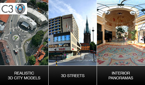
Is Apple positioning itself as a Google Street View and Microsoft Bing Maps competitor? Apparently, Apple recently acquired C3 Technologies' also offer Street View and Interior views.

From the entry: "In addition to 3D maps, C3 also makes awesome street level imagery captured using "an advanced multiple camera system with overlapping viewing angles to capture the entire surroundings in stereo. [...] As well as increasing its geographic range, C3 is expanding into interior settings. With a special camera rig, they can also create a 3D model of the interior of a building using the same photo stitching they use with their aerial or street level maps."

Read More »

Apple Acquired 3D Mapping Company ‘C3 Technologies’

Over the weekend, MacRumors shared news of the confirmation that Apple Did Acquire 3D Mapping Company C3 Technologies.

From their entry: "C3 Technologies made a big splash at CES when it began demoing its technology on both Android and iOS devices. The company uses formerly classified missile targeting technology to achieve its impressive 3D mapping effects. The company's official YouTube videos have been pulled, but some examples remain."

Head to the website for videos and screenshots. We did mentioned C3 Technologies three times since.

Read More »

Batch Geonews: ArcGIS for Android 1.0 Released, GeoIQ Social, Business Interiors in StreetView, Income Inequality, and more

First, I'm sorry for not publishing the "batch mode" version of the geonews for the last two weeks - along with several other responsibilities, taking care of two young daughters at home is certainly fun, but engulfs all available time. In this batch mode edition, there are certainly a few geonews that could deserve their own entry - click on what interests you to learn more!

From the Google front:

  • In my previous Google entry earlier today, I forgot to mention the GEB entry detailing even more major improvements of Xavier Tassin's Google Earth Flight Simulator, now at version 0.7
  • This one via APB, Google Maps rolls out business interiors in Street View

From the Esri front:

  • Via VerySpatial, ArcGIS for Android 1.0 has been released
  • Two weeks ago, mandown informed us that the ArcGIS 10 Service Pack 3 Now Available For Download

From the miscellaneous category:

  • GeoIQ launched GeoIQ Social, "the first and only product that provides self-service analysis of social media data by time and location"
  • On the OGC blog, there's an interesting short entry on "Big Data" vs SDI in geospatial
  • Clearly, WebGL is en vogue, mapperz mentiones the new Nokia Maps 3D WebGL, and Nokia is readying LiveView, which blends maps and augmented reality for their upcoming Windows Phone
  • Apple expanded iPhone 4S GPS capabilities with GLONASS support and Apple Siri's support for maps and local search is coming to international customers in
  • MapQuest refreshed their Developer Network
  • The name Atanas Entchev ring a bell to you? He's an active member of the geospatial community and he needs our help, he's facing deportation from the U.S.

In the maps category:

  • Mapperz mentions the UK car crash map
  • Ok, not exactly a map, but trying to find what are the Wall Street protestors are so angry about, here's a breakdown of income inequality, the Gini coefficient, by countries
Read More »

Google MapsGL Launched and Other Google Geonews

Since the beginning of the year, we heard about geospatial uses of WebGL, and now, Google announced Google MapsGL.

The improvements are simply described as: "With WebGL your maps experience is much better with 3D buildings, smoother transitions between imagery and the ability to instantly “swoop” into Street View without a plugin." Particularly in geospatial, changes are easier to grasp when visualized, here's the short video showing the differences between Google Maps and Google MapsGL. You do need Chrome or the latest Firefox.

Other recent Google geonews:

  • Here's an official entry on faster updates to local business listings
  • The GEB shares an entry on A tribute to Steve Jobs in Google Earth
  • And an entry on the Sea Ice Extent Animation updated
Read More »

Apple Announces ‘Find My Friends’ Location Service

In their round of announcements, Apple today announced the 'Find My Friends' location app and service. Here's what the Apple press release has to say about it:

"Find My Friends is a new app available as a free download from the App Store that lets you easily share your location with people who are important to you. Friends and family appear on a map so you can quickly see where they are. Find My Friends also lets you temporarily share your location with a group of friends, whether it's for a couple of hours for a dinner or a couple of days on a camping trip; when the time is up, the sharing ends. With Find My Friends, you get a notification every time you get a new friend request and if you give them permission, they can see your location. With a simple tap you can hide your location. Parental controls help you manage how your child uses Find My Friends."

It will be available on October 12th along with iOS 5. This service has similarities with Google Latitude, launched in February.  

In related news, the iOS Maps app can apparently be invoked and used via the new Siri advanced voice recognition part of iOS 5.

Read More »

Geonews CatchUp: QGIS vs gvSIG, Landsat 8 Milestone, Shaderlight 2, osmdroid, and too much more

That's probably our biggest "geonews in batch mode" issue ever. That's the price I have to pay for three weeks of holidays! ;-) I tried to keep only the most pertinent geonews. After reading this unusually long entry, you and I are back to being up to date in terms of geonews.

On the Google front:
  • Here's a Google Earth mashup of Fukushima and Chernobyl meltdowns side-by-side
  • Google added a Regional Expert Reviewer Program to Google Map Maker
  • The tool Shaderlight to create awesome SketchUp models is now at version 2
  • Google purchased Zagat Survey, a firm offering local ratings of restaurants and much more  
  • And there's new imagery in Google Earth released on September 7
On the ESRI front:
  • ArcGIS 10.0 SP3 is coming next month
  • Spatially Adjusted has an entry seemingly confirming You Can’t Edit Spatial RDBMS with ArcGIS for Desktop without SDS
  • V1 reviews the Esri Map Book, volume 26
On the open source front:
  • Via no solo I read this informative QGIS and gvSIG comparison, useful to understand the differences between what are probably the two most mature open source desktop GIS packages available
  • The FOSS4G conference will take place in Beijing, China
  • We did mention them before, but only indirectly - here's osmdroid, OpenStreetMap tools for Android (maybe that's what missing for iOS?)
  • In case you don't read our geospatial press releases, the OSGeo-Live 5.0 DVD has been released
  • If you're interested in Brazilian topography, see this entry on TOPODATA's version of SRTM-DEM for Brazil

In GPS news:

  • North Korea forced a US reconnaissance plane to land by jamming GPS signals
  • Via Spatial Law, Bangladesh Mandates Use of GPS in Vehicles

In Apple news:

  • Autodesk released the 'Lite' version of AutoCAD for MacOS X, in addition to the full version available since a year
  • For their iOS devices, Apple is exploring enhancing maps with augmented reality
  • APB mentioend Apple's patent application on crowdsourcing data for local searches
  • The class-action lawsuit against Apple in South Korea over location data collection has started 

In Microsoft news:

  • Streetside is now available for parts of London
  • Microsoft shares an entry on the Bing Maps v7 Module CodePlex Project
  • Even if Virtual Earth 3D is discontinued, Microsoft posted details to enable you to use it longer
  • Microsoft released the Bing Maps 'Windows Presentation Foundation' (WPF) Control
  • Here's an entry on the Wall Street Journal using Bing Maps in their hurricane tracking tool

In transportation news:

  • SignalGuru system that change your route to avoid red lights
  • Regarding tracking and privacy, the NYC mayor wants traffic cameras at every corner

In remote sensing news:

  • A critical milestone has been reached for Landsat's LCDM mission in, aka "Landsat 8"
  • Both NigeriaSat-2 and NigeriaSat-X remote sensing satellites have been launched successfully
  • The ERS-2 mission is completed, its last image has been taken
  • Can you believe that over 700 government satellites will launch in the next 10 years? Obviously not all for remote sensing purposes
  • The bankrupted RapidEye has been purchased
In the miscellaneous category:
  • It seems UniStrong has 40% of GIS marketshare in China
  • V1 shares a perspective named Where Did All the Talk About Spatial Data Quality Go?
  • The data provider Infochimps have a new GEO API
  • Slashdot discusses a story named Judge Nixes Warrantless Cell Phone Location Data
  • Of course I'm a bit too late, but here's a recap of mapping and mobile data for Hurricane Irene
  • Here's an entry named Everything you wanted to know about UK Coordinate Systems
  • It's confirmed, Kansas is flatter than a pancake
  • Do we need another map building website? There's the new Build-A-Map site in Beta
  • APB mentions 'Location Aware', a free location-aware task management app for Android

In the maps category:

  • O'Reilly shared a map of U.S. job losses
  • Here's the U.S. National Parks as seen from space
  • Tthe USGS launched their Historical Topo Map Collection
Read More »

Saturday Geonews: TileMill 0.4.1, Esri FileGeodatabase API 1.1, GIS with Google Earth, Layar Vision App, and much more

Here's the recent geonews in batch mode. Yes, on a Saturday! I'll be away for the next three weeks and dare delay my family's departure to feed you with these.

From the open source front:

  • Mentioned before, the open source map design tool TileMill reached version 0.4.1   
  • Some recent improvements of QGIS: an extraction projection tool for QGIS, a new MapInfo to QGIS style converter and Shield Labels for QGIS
  • Not the first time it happened, a briton got arrested during his OpenStreetMap mapping activities, yes, that was before the recent London riots
  • O'Reilly offers an entry named Open source maps tell data journalism stories in Afghanistan
  • Paul Ramsey of the PostGIS fame shares interesting arguments on the open source vs proprietary debacle
  • Here's an entry on generating elevation maps from along-track stereo pairs using the open source Orfeo ToolBox
  • We told you ourselves a few times, but here's how James Fee telling us Why You Can’t Afford to Miss FOSS4G

From the Esri front:

  • The File GeoDatabase API version 1.1 has been released, in includes a .NET wrapper and bug fixes
  • James Fee mentions PgMap and QMap to connect to spatial databases with ArcGIS 10.1 without SDE

From the Google front:

  • In their learning series, here's an entry on GIS with Google Earth and Google Maps
  • Google shares an entry on famine crisis relief in the Horn of Africa
  • Here's the 50th anniversary of the building of the Berlin Wall in Google Earth
  • Google invites us to visit the Hiroshima Peace Memorial with Google Maps

On the Microsoft front:

  • Microsoft updated their Bing Maps Account Center with three main improvements: Direct Publishing of Data Sources, Map Navigation for Data Editing, and Enhanced POI Data Search
  • Here's an entry named KinectFusion Provides Low-Cost and Accessible 3D Interior Mapping

In the miscellaneous category:

  • The Spatial Law blog shares a long entry named Geolocation and Privacy: Are We Going the Right Way?: "However, many of bills are so broadly written that if they were to become law they could apply to a broad range of geospatial products and services, including satellite and aerial imagery, GIS and GPS."
  • VerySpatial mentions the launch of the augmented reality Layar Vision app to "recognize real-world objects and then trigger digital content based on that object"
  • The GEB shares satellite imagery on the Japanese Tsunami that created some massive icebergs
  • MacRumors details an Apple patent on schematic maps: "[...] a new maps application that could display a simplified subset of information most relevant to a user seeking specific information or routing."
  • In special remote sensing news, Slashdot mentions a camera reaching its target by being thrown by a grenade launcher
  • MapQuest tells us how free listing works on their MapQuest Local Business Center

In the maps category:

  • O'Reilly discuss maps of the recent London riots
  • Mapperz mentions the release of USGS historical maps
Read More »

Thursday Geonews: Bing Maps Map Style Updated, London Transit in Google Maps, Timezones Shapefile, Backseat Driver, and much more

Here's the recent geonews in batch mode covering the last two weeks. It's a bit longer than usual.

On the open source front:

  • Almost two weeks ago, the OSGeo released their 2 minutes video promoting the FOSS4G conference, Slashgeo is proud to be a media partner
  • The FGT blog offers a long entry on the portable version of gvSIG, an open source GIS - portable meaning running from a USB key with a host computer with no intallation required
  • Several sources mentioned that Canada's British Columbia opened their province-wide open data portal, with plenty of geospatial data in it
  • While we mentioned the its preview in May, here's more documentation on the upcoming GeoRepository, an advanced authorization manager for GeoServer
  • ImageI/O-Ext 1.1.1 has been released
  • uDig 1.2.2 has been released too
  • There's a PostGIS Drupal module in the works

On the Google front (well, new since yesterday):

  • Public transport directions of London is now available in Google Maps
  • Google details the new Google Maps version 5.8 for Android, adding photo uploads and My Places
  • Mapperz tells us how to load OpenStreetMap data in Google Earth via FME with BBOX.ME

On the Microsoft front:

  • Most visible changes for users are updates to the Bing Maps road map style, they even offer a 9-pages guide to detail what 's new
  • APB reports that Microsoft will use Gigwalk to enhance Bing Maps search results
  • Microsoft announced Bing Maps updates to Account Center, REST Services, and Documentation
  • Another entry enumerate what's new in the Bing AJAX Map Control

In the miscellaneous category:

  • O'Reilly links to a free shapefile of the TZ timezones of the world
  • SS mentions the GeoTime software that "displays movement over time in an intuitive manner"
  • Here's an article on the technical, scientific, historic and political background to the GPS system
  • On the topic of the future of GPS, V1 shares an entry named the Significance of LightSquared Debate to Europeans and APB shares ESA's reaction to LightSquared potential interference with Galileo
  • MacRumors have an entry named Apple Pays $946 in Korean Lawsuit Over Location Data Collection, New Class Action Suit Coming
  • In the funny category, APB mentions (video included) ToyToyota's Backseat Driver GPS iOS game for kids that uses the real-time itinerary of the car

Discussed over Slashdot:

  • 3D Hurts Your Eyes
  • Chief NSA Lawyer Hints That NSA May Be Tracking US Citizens
  • Google Grabbed Locations of Phones, PCs
  • Undersea Cable Map Shows Where The Data Pipes Are

In the maps category:

  • SS shares an entry named eLEAF Maps the World’s Water for Food Security
  • Ready for the hurricane season, the UK Met Office launched their Storm Tracker (beta), with free and paid versions, and on the same topic, the GEB offers an entry on tracking hurricanes in Google Earth
  • V1 mentions Africover WebMap from the UN, offering geodata for Africa
  • O'Reilly have an entry on cellphone connections in the U.S.
Read More »

Google Geonews: Sony Project Shiphunt, Brussels in 3D, Tracking Dengue Fever, The End of Anonymous Shopping, and more

Here's the recent Google-related geonews. From the official sources:

  • Here's an entry on Belgium's Brussels in 3D in Google Earth, named Europe’s best kept secret revealed in 3D
  • Google updated the Help Center of Google Map Maker
  • Google is updating their maps data from authoritative sources for France, Monaco and Luxembourg
  • Google shared an entry named using search patterns to track dengue fever
  • Google's Ed Parsons shared his Location Business Summit slides, a presentation named "Making the most of place", Google Places, of course
From other sources:
  • Here's a 3D model of Joplin tornado debris
  • Slashdot ran a discussion named Google Wallet: the End of Anonymous Shopping, about the probable upcoming systematic location tracking of all purchases
  • It seems Apple Just Renewed Maps and Search Partnership with Google
  • The GEB has an entry named Space Archeologists discovering egyptian tombs
  • The same site is also enthusiastic about Sony's Project Shiphunt, a fun game using Google Ocean
  • And there was a new imagery update on May 31th
Read More »

EU Demands Explicit Geo-Location Permissions

Slashdot discusses a story named EU Demands Explicit Geo-Location Permissions. Their summary: "Apple, Google and employers are already contravening new European Union rules that will require companies to get explicit permission from users before any geo-location data can be used to track them, whether for the purposes of targeted advertising or monitoring employee behavior. This could be the start of the next big privacy argument. The hopes of companies planning to use geo-location data to push products and services to mobile device users have taken a beating in the European Union, following a pronouncement from the European Data Protection Supervisor, Peter Hustinx."

Read More »