Tag Archives: Google Maps

Google Geonews: Major Maps Update in Europe, Google Maps Android API Update, NASA’s Black Marble, and more

Here's the recent Google-related geonews.

From official sources:

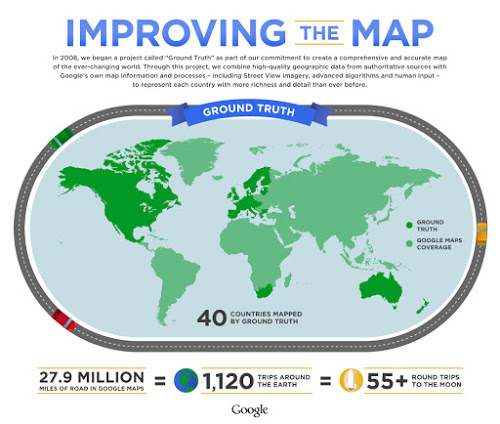
  • Google released updated maps for 10 countries and regions in Europe: "Andorra, Bulgaria, Estonia, Gibraltar, Hungary, Latvia, Lithuania, Slovakia, Slovenia and Spain". Data comes from authoritative sources part of the Ground Truth project (screenshot below)
  • Google released a major update to the Google Maps Android API: it "features vector-based maps that load quickly and enables users to easily navigate 2D and 3D views, and tilt and rotate the map with simple gestures"
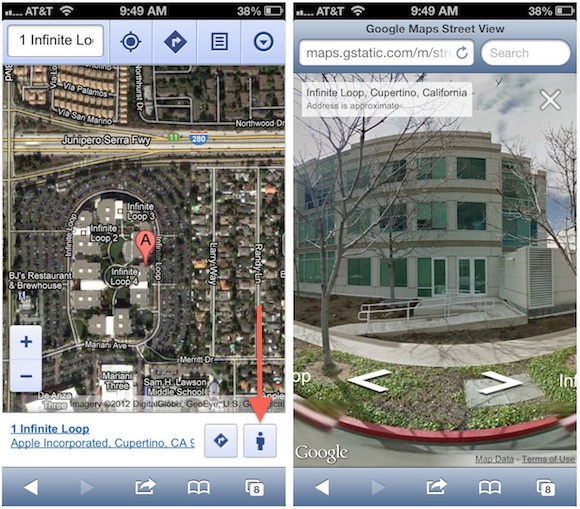
  • There was an entry on the Crisis Response map for Typhoon Pablo (Bopha) and the digital archives of buildings in Japan affected by the tsunami

From other sources:

  • The GEB informs us that we can see NASA's "black marble" in Google Earth: "an amazing view of the earth covered in darkness with only city lights glowing"

Read More »

Google Employees Suggest Apple Approval of Google Maps App ‘Unlikely’

Discussed both on Slashdot and MacRumors, respectively, Google Doubts Apple Will Approve Its New Maps Application and Google Employees Suggest Apple Approval of Google Maps App 'Unlikely'.

The Slashdot summary: "Even though Apple's App Store has also been friendly enough to offer alternative mapping applications to ameliorate customers upset with Apple's new default Maps app, the Cupertino, Calif.-based company may not be so friendly as to approve a Maps app submission from Google, which used to be responsible for the Maps experience in iOS until the iPhone 5. On Monday, sources at Google familiar with its mapping plans said the chances of Apple approving a dedicated Google Maps app on iOS 6 are 'not optimistic.' Specifically, they pointed to the lack of any mapping app in the 'Find maps for your iPhone' section of the App Store — accessible only via iPhones or iPads — that use the Google Maps APIs to call wirelessly for location, routing or point-of-interest (POI) data."

Read More »

Google Earth 7 Released, Google Maps’ New Natural Geography, Post-Sandy Imagery, and Other Google Geonews

A new major version of Google Earth doesn't happen everyday, explore the world with tour guide and 3D imagery in Google Earth 7.

From the announcement: "A few months ago, we announced Google Earth for mobile, which offered new ways to see cities in 3D and a new tour guide feature to help you discover places of interest on the go. Starting today, you can get both of those features on a bigger screen that makes it even easier to explore by downloading Google Earth 7 on your desktop. Check out the comprehensive and accurate tours of more than 11,000 popular sites around the world, including our growing list of cities where new 3D imagery is available."

Other recent Google geonews:

  • I'm very happy that we get a better view of natural geography with Google Maps, follow the link for before/after images, but in short, Google Maps now shows us natural geography like forested and mountainous areas when zoomed out - much much nicer. And here's some more information for developers
  • Google also released the first batch of post-Sandy imagery to Google Earth (image below)
  • You can now add your Photo Sphere images to Google Maps with Android 4.2
  • Here's a script to View all of your Google Contacts in Google Earth
  • An entirely other topic, Google Earth reveals the secret of Angkor Wat's construction
  • Much less funny, Imagery of sectarian destruction In Burma’s Rakhine state now on Google Earth
  • APB tells us that Google and Friends Launch Privacy-focused Crowdsourced Image Blurring Service in Germany
  • And there's fresh imagery for everyone

Read More »

Google Geonews: Biggest Street View Update, New GM Tracks API and GM Geolocation API, GM for iOS Alpha, and more

Here's the recent Google-related geonews.

From official sources:

  • Google made their biggest Street View update ever: "[...] doubling our number of special collections and updating over 250,000 miles of roads around the world. We’re increasing Street View coverage in Macau, Singapore, Sweden, the U.S., Thailand, Taiwan, Italy, Great Britain, Denmark, Norway and Canada. And we’re launching special collections in South Africa, Japan, Spain, France, Brazil and Mexico, among others."
  • There's expanded coverage of building footprints in Google Maps: "25 million new building footprints that have been added to Google Maps"
  • The Dev blog introduces the Google Maps Tracks API and the Google Maps Geolocation API:
    • Google Maps Tracks API allows an organization to build applications that can store, display and analyze GPS data on a map.  The API is built on top of Google’s reliable cloud infrastructure and offers specialized features such as geo-fencing.
    • Google Maps Geolocation API enables an application or device to determine its own location without the use of GPS by looking up the locations of nearby wifi access points and cell towers. By limiting GPS usage, a device can save battery life and work indoors or in remote areas.
  • Here's Street View inside Google's data centers

From other sources:

  • Here's early screenshots of Google Maps for iOS in alpha testing
  • The GEB tells about weather in Google Earth
  • And of course, there was the expected satellite imagery update

Read More »

Google Geonews: Street View in Mobile Browsers, Google Maps API Gallery, and more

Here's the recent Google-related geonews in batch mode.

From official sources:

  • Google announced Street View comes to Google Maps on your Mobile Browser: "Starting today, use Street View on your mobile browser to check out a new shop across town or get a feel for the ambiance at a restaurant before you arrive. To use Street View on your mobile browser simply go to maps.google and search for a location. Then click the “pegman” icon at the bottom right of your screen to access Street View."
  • Google also launched MoreThanAMap to showcase uses of the Google Maps API
  • Google's Ed Parson chimes in on the Apple Maps woes: "[...] the bigger issue is the lack of a true geocoded search index of places and the search algorithms that sit around it. Local search is in many ways what makes smart phones smart, because the users location and the location of things around them provides a set of contextual pointers to relevant information."
  • There's traffic estimates now available for enterprise customers in the Google Maps API
  • Yes, there's new imagery, including new 45deg imagery for 51 cities

From other sources:

  • Slashdot ran a discussion named Google Glass, Augmented Reality Spells Data Headaches, with Google Glass being the topic of our current poll (right hand side column)

Read More »

Google Geonews: Google and Apple Maps, Street View Goes Underwater, Many Data Updates, and more

Please allow the recent silence, busy week, I should be able to catchup next one. Here's the recent Google-related geonews.

Regarding Google and Apple Maps:

  • MacRumors claimed that Apple's Split with Google Over iOS Maps Driven by Turn-by-Turn Navigation Dispute, that Google's Work Toward Standalone iOS Maps App Complicated by Integration with Google Earth and apparently, Apple Reportedly Had Over a Year Left on Maps Contract with Google
  • Slashdot discussed Apple Reportedly Luring Ex-Google Mappers With Jobs

From official sources:

  • Google Maps now offers underwater imagery, a topic discussed by Slashdot in Google Captures 'Street View' of Underwater Habitats
  • Street View reaches other new places, introducing Imagery of Chile and Croatia on Google Maps, and Andorra too
  • Google Maps for Android has been updated, and you get all your Google Maps searches in one place
  • Live Road Traffic Launches in 3 New Countries, in three new cities: Jeddah, Saudi Arabia; Kuwait City, Kuwait and Guayaquil, Ecuador
  • Your can now explore the great indoors of France with Google Maps for Android

From other sources:

  • Slashdot discussed California Legalizes Self Driving Cars, and to my knowledge, Google is leading the way the car's future
  • Here's Geoception, a new Google Earth-based game: "In a nutshell, you command and control a fleet of combat drones to provide local and regional security, eventually taking over the whole world."
  • The GEB also offers an entry named Cambodians fighting malaria with SMS and Google Earth
  • And yes, there was another imagery update
Read More »

Batch Geonews: shp.js, QMap, SPOT 6, Google Ground Truth Project, and much more

Here's the recent geonews in batch mode.

From the open source / data front:

  • MapBrief claim that the battle for open source in the enterprise in behind us, from the WSJ: "[...] for reasons including ease of innovation and cutting the time to get products to market"
  • Interesting, announcing QMap: A simple data collection application using QGIS
  • Unless I'm mistaken, we haven't mentioned yet the new 'shp.js' open source javascript Shapefile parser (via GGD)
  • In case you missed it in our PR section, there's an Education version of gvSIG
  • GeoTools 8.1 has been released, mostly a bug fix release
  • Portable GIS version 3 has been released too
  • Here's a summary of State of the Map held in Tokyo
  • It's done, OpenStreetMap data license is now ODbL
  • And yes, some crazy people try to sell open source geospatial code

From the Esri front:

  • Here's What’s New in ArcGIS Online for September

From the Microsoft front:

  • New imagery to Bing Maps, a lot of it, Global Ortho & 17 Million SqKm of New Satellite Imagery

From the Google front:

  • Plenty of geoblogs mentioned the Atlantic article on the secretive Ground Truth program in an article named How Google Builds Its Maps—and What It Means for the Future of Everything
  • Google shares a breakout of Google Maps search terms by country for this Summer
  • They also have an entry on the need to save the elephants and how to do it the geospatial way
  • You can also Explore the Forefront of Japanese Space Science with Google Maps
  • Here's the official entry on the latest imagery update in Google Maps and Google Earth, a lot of it
  • The GEB shares an entry on Viewing city lights in Google Earth and why not, another entry on Google Earth Fractals

Interesting Directions Mag articles:

  • Does Your Local Government Need A Drone?
  • New Spatial Information Act for Australia
  • Trucking Fleets Leverage Traffic Data to Work Smarter, Cut Costs
  • New Resources for GIS Job Seekers

In the miscellaneous category:

  • The SPOT 6 satellite is alive and well with its first images, it was successfully launched on September 9 and has a spatial resolution of 1.5m
  • LizardTech (MrSID) Releases Express Server 8

In the maps category:

  • Via APB, here's a Map the World’s Friendships from Facebook and Stamen
  • Here's a gigantic 3D map of the deaths in Grand Canyon
  • NASA wants you to help map an asteroid
Read More »

Batch Geonews: Shapefiles in Bing Maps, 80% of Data is Not Spatial?, In-Location Alliance, ArcGIS for AutoCAD 300, and much more

This is my tentative to catch up the geonews since my mid-August holidays. Here they are!

On the open source / open data front:

  • UDig 1.3.2 has been released with several new features and supports Axios spatial editing tools again
  • Since the USGS provides the Landsat archive, but this entry mentions that a substantial part of the Landsat archive is available on the fast and reliable public Google Earth Engine cloud storage

On the Esri front:

  • The free plugin ArcGIS for AutoCAD version 300 is now available
  • There's now an ArcGIS Runtime for iOS for ArcGIS WebMaps

On the Google front:

  • Google made a few Google Maps announcements, including voice guided directions in India, Map Maker in New Zealand and new Street View in 150 university campuses
  • In another entry, Google offers a roundup of their August Google Maps related news, most news we already shared with our users
  • Nothing surprising, new imagery released on September 1

On the Microsoft front:

  • Microsoft shares an entry on overlaying Esri shapefiles in BIng Maps
  • Microsoft's Global Ortho Project is complete for the United States, meaning there's high resolution 30cm imagery everywhere in the country
  • There's a new Bing Get Me There App for iOS for London, UK
  • An entry on Bing Maps V7 AJAX Highlights

In the everything else category:

  • James shares a must-read short entry named '80% of Data Is Not Spatial So Stop Claiming It Is', read the comments for insights
  • Here's a pertinent entry related to a UN paper, Criticism - Future Trends in Geospatial Information Management: The Five to Ten Year Vision
  • Here's an update on the OGC standards and the semantic web (aka Linked Data)
  • APB informs us that 22 companies formed the In-Location Alliance to Enhance Indoor Positioning
  • O'Reilly links to an article on Yelp Checkins to Measure Geopositioning Accuracy Across Phones
  • Slashdot discuss the Location Privacy Act Approved By California Legislature
  • Other stories at Slashdot, The Rapid Rise of License Plate Readers and UK License Plate Cameras Have "Gaps In Coverage"
  • Big numbers, APB indicates that the GIS market will soon reach between 3.7 - 10.6 Billions, depending on who you ask

In the maps category:

  • On APoD, there's a pretty interesting map of hurricane and tropical storms paths (screenshot below)
  • An interesting map of the Global Decline in Religiosity
  • Some London Olympics maps: The politics of London Olympic medal counts

Read More »

Google Geonews: Biking Directions on Android, Map Maker and Street View Updates, and more

Slowly starting to catch up mid-August geonews, here's the associated recent Google ones.

From official sources:

  • Bikers rejoice, biking navigation in 12 countries in Google Maps for Android: "That’s why today we’re bringing mobile biking directions and navigation to the 10 countries [...]. Plus, we’re adding turn-by-turn, voice-guided biking navigation to Google Maps Navigation (beta) in every country with biking directions."
  • There's Map Maker updates for Lesotho, Oman and Trinidad & Tobago and Detroit, Michigan
  • Street View:
    • Google Maps and Street View are going to Canada's far north
    • Street View is also much improved in Brazil and prehispanic Mexican cities
    • You can See Rebuilding in New Orleans Through Updated Street View Imagery
  • As a public transport daily user, I'm happy that Google Maps now has schedules for more than one million public transit stops worldwide
  • We did mention geo-wiki last February, and now Google shares an entry named Validating Land Cover Datasets with Geo-Wiki, using a blend of Google tools and open source ones (e.g. MapServer, PostGIS)

From other sources:

  • The GEB links to 'A New Life' new country generator in Google Earth for use in education and fun
  • APB mentioned Google acquired 7 deCarta LBS patents
  • There's still much left to discover on this planet, New Egyptian pyramids found using Google Earth?
  • There's Mars' Curiosity rover imagery in Google Mars now
Read More »

Google Geonews: My Tracks 2.0, Biking Directions in Europe, Indoor Maps in Museums and in the UK, 11,000 Tours, and more

Here's the recent Google-related geonews. From official sources:

  • Google announced the release of My Track 2.0, the open source app on Android to generate GPS/GNSS tracks and share them in Google Maps and Google Earth
  • Biking directions in Google Maps expands to several countries in Europe and Australia, a topic also discussed on Slashdot
  • In the latest Google Earth for Android (and upcoming for iOS), they included a new tour guide feature for visual trips using the great new 3D imagery they are adding. There is 11,000 tours available covering 110 countries!
  • California's National Parks are now available in Street View
  • Walking directions made its way in Google Maps for Africa
  • In the latest Google Maps for Android, you now get indoor maps of 20 popular museums, added to the 10,000 other indoor maps they already provided
  • Related, there's an entry on going indoors at locations across the United Kingdom
  • There is new 45° imagery available for 31 cities including 26 cities in the U.S. and 5 international locations
  • Google also offers an entry on Map Makerpedia, their community tool for Google Map Maker (but you already know I prefer OpenStreetMap, for openness reasons)
Read More »