Tag Archives: Google Maps

Google Geonews: Google Maps Engine Lite Launched, User Testing of Google Glass Started, and much more

Here's the recent Google-related geonews.

From official sources:

  • A new mapping tool offered by Google, Create, collaborate and share advanced custom maps with Google Maps Engine Lite (Beta): "Of course, experts aren’t the only ones who love to make maps. Today we're launching Google Maps Engine Lite (Beta), so any mapping enthusiast can now create and share robust custom maps using this powerful, easy-to-use tool. You can import small spreadsheets of locations onto a comprehensive map, visualize those places through a variety of styling and drawing options, and organize and compare up to three different data sets for your non-business purposes." For those who don't remember, 'Google Maps Engine' is the new name of what was known as 'Google Earth Builder'.

  • Google also started looking for Explorers to test drive Google Glass, which we will definitely hear often about in the coming months - Slashdot discusses Google Glass in three discussions: Lawmakers Seek To Ban Google Glass On the Road, Should We Be Afraid of Google Glass? and Google Glass and Surveillance Culture
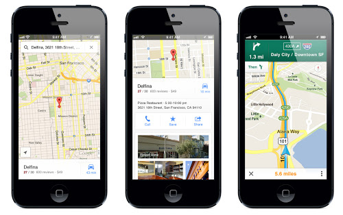
  • There's Live transit information in more cities on Google Maps: "live departure times for seven lines on the New York City subway system (MTA), as well as for buses and trams in the greater Salt Lake City area (UTA). With these updates – part of the millions of live transit schedule updates we process every day – you get instant access to the latest information right on Google Maps, making trip planning a cinch."
  • Google released Imagery on Google Maps of Fukushima Exclusion Zone Town Namie-machi also discussed over Slashdot in a story named Google Releases Street View Images From Fukushima Ghost Town
  • If there's a Pirate in you, or you have kids, you might be interested in Finding treasures with Google Maps, related, here's about Teaching about the ocean floor with Google Earth
  • Google invites us to Explore Everest, Kilimanjaro and more with Google Maps
  • If you're a non-profit organization, you might be interested in making a map that will change the world with Google Earth Outreach Developer Grants
  • Other minor official entries include: Google Maps shows Amazon funds at work, Trekker takes on Canada’s Arctic Winter and A behind-the-scenes look at our latest Google Maps special collection

From other sources:

  • The GEB has a short entry on Managing KML and KMZ files on mobile devices
  • What used to require a GIS, here's about Using Google Earth terrain data to plan wireless networks
  • APB share links about Google Indoor Mapping: Does it Work? WIll it Save Brick and Mortar Retail from Web Competitors?
  • APB also shares an entry on Queensland Putting its Data On Google Earth
  • Guess what, there was new imagery to Google Earth a bit less than 2 weeks ago, other minor stories from the GEB includes Researchers rediscover lost butterfly species with the help of Google Earth, Race Formula One tracks with Google Earth and An in-depth look at the history of Street View
Read More »

An In-Depth Comparison Between iOS Map Frameworks: Apple MapKit vs. Google Maps SDK

MacRumors summarizes a full entry on an In-Depth Comparison Between iOS Map Frameworks: Apple MapKit vs. Google Maps SDK. Really an informative article, go read it.

From the comparison: "The Google Maps for iOS SDK isn’t all roses, however. McKinlay warns that Google applies usage limits and quotas to their Places Search API, so if your app gets too successful then you get “punished” for it. [...]  There were a few reasons we chose to implement a dual mapping solution. The first was where we couldn’t do everything we needed on the Google Maps so had to keep Apple Maps, otherwise we would be removing features from our app (such as advanced overlays and gradient polylines)! [...]  However, Armstrong adds that MapKit only wins for now: “Ask again in six months’ time and that opinion may have changed.”" 

Read More »

Google Maps for iOS Receives First Update, Version 1.1

I guess this would normally not be major news, but since a lot of iPhone users rely on it and that alternatives like Apple Maps and Blackberry Maps have not impressed the press so far, here it is: Google Maps for iOS version 1.1 has been released, but no iPad compatibility yet.

MacRumors informs about it: "What's New in Version 1.1:

  • Search your Google Contacts; sign in to have your saved addresses show up when you search for friends and family by name.
  • Quickly search for local places by selecting popular categories such as restaurants, bars, cafes, gas stations, etc.
  • Choose between Kilometers or Miles for your preferred distance units.
  • Note that some features may not be available in all countries."

Read More »

Google Geonews: New 3D Imagery for Cities, Mapping Meteo Impacts, Google Earth for Research Book, Multiplayer Games, and more

I have a lot of geonews to catchup. You'll get everything that's pertinent (at least from my point of view ;-), but just a bit later than usual. Thanks for your patience!

Here's the recent Google-related geonews. Nothing major, but several interesting items.

From official sources:

  • The first update to the Google Maps SDK for iOS
  • Google informs us that Ski Resorts are now on Google Maps

From other sources:

  • The GEB informs us that Google released 3D imagery in Berne (Switzerland), Anaheim (California) and other cities around the world
  • Ogle Earth has an entry named Reconstructing the Chelyabinsk meteor’s path, with Google Earth, YouTube and high-school math
  • Related, the GEB has an entry named Mapping meteor impacts
  • Still the same source a book named "Google Earth and Virtual Visualizations in Geoscience Education and Research"
  • The GEB shares a kmz to watch U.S. watersheds in Google Earth
  • The GEB reminds us that we can animate GPS tracks in Google Earth
  • You're an Olympics fan? Previewing the Winter Olympics in Sochi
  • If you prefer Grand Prix racing, Ride along GP tracks from all over the world
  • There has been games for Google Earth for a while, but now we're talking about multiplayer games: Two player driving shooter game in Google Earth
Read More »

Google Geonews: Detailed North Korea in Google Maps, 100,000 New Tours, Android Photo Spheres in Google Earth, and more

Here's the recent Google geonews in batch mode.

From official sources:

  • Google published more detailed maps of North Korea, to the point where Slashdot discussed a story named North Korea's Prison Camps Are Now On Google Maps with this summary: ""It's been nearly a decade since Shin Dong-hyuk, an ex-prisoner of North Korea's Camp 14, crawled over the electrocuted body of a friend lying dead on a fence, a boundary he was born inside of and lived within for 23 years. He made his way across the Chinese border on foot and was granted political asylum and citizenship in Seoul. Now, thanks to updated Google maps of the region, you can actually (if somewhat loosely) retrace the steps of his incredible escape. Through its Map Maker program, which crowdsources cartographic info, Google has published finer details of some North Korean roads. More notably, it has included shaded-in locations of the country's notorious prison camps. The data has flowed in from a few different sources, including defected North Korean expats now living in Seoul. Geographically-minded tourists and visitors of North Korea have weighed in, and historic map data from pre-partitioned Korea into has also been helpful. (Google maintains that the recent trip to Pyongyang by CEO Eric Schmidt had nothing to do with this project.)"
  • Google invites you to explore the Grand Canyon on Google Maps
  • An official entry named Google + Audi: Enhancing Navigation

From other sources, this time all from the GEB blog:

  • Nothing less than 100,000 new tours added to Google Earth
  • A nice addition, You can now view Android "photo spheres" in Google Earth
  • There's New Street View imagery from the Grand Canyon, Japan, Lithuania and updates elsewhere
  • First time I see this, Using Google Earth for 3D Property Listings basically showing apartments for rent over 3D buildings
Read More »

Google Geonews: Update on Project Glass, Summary of for Google Earth, and more

Here's the recent Google-related geonews, including the holiday break.

From various sources:

  • Here's an update on Google Project Glass, with the feature set and state of its augmented reality apps, APB also shares a summary
  • Apparently, Google Maps on Windows Phone 8 was blocked by Google, it's not the case anymore
  • The GEB compiled The Year in Google Earth, a nice summary of what happened on that front
  • Slashdot wonders what was spotted in the Chinese desert with Google Earth, and Ogle Earth provide the answers along with a great quote: "It is above all a story about technology racing ahead of our ability to put it into context."
  • Updates to the Google Earth Flight Simulator
Read More »

Comparing Apple’s Maps and Google Maps, and Other Related News

Tidbits offers an interesting article comparing Apple Maps with Google Maps.

The article's conclusion: "In the end, I believe that the real area where Google Maps stands out from Apple’s Maps is in transit directions, which I can’t test, but which have been praised by city dwellers like David Pogue of the New York Times, and Jacqui Cheng of Ars Technica, Dan Moren of Macworld, and Andy Ihnatko of the Chicago Sun-Times. Otherwise, both apps do a decent job and do so with entirely reasonable interfaces. Apple’s mapping data undoubtedly isn’t as good as Google’s, overall, but in most cases, I doubt that it will make a significant difference. And it’s now easy enough — thanks to the “via transit” trick — to compare routes in both apps, though I suppose that then raises the issue of which you want to believe."

Related news include:

  • MacRumors informing us that Google Maps for iOS Downloaded More than 10 Million Times
  • From the same source, Apple Reportedly in Talks for Data-Sharing Deal with Foursquare

Read More »

Uber Weather Maps Leveraging Google Fusion Tables

Google has re-invented maps and GIS. Now we have "Consumer GIS" at a scale and speed that is unprecedented. If you have not played with it, the "Secret Sauce" is Google Fusion Tables (GFT). GFT allows almost unlimited data to be displayed on a Google Map and it is "Clickable". And did I mention it is free!

So what can you build with this? Check out Uber Weather. Built by one programmer with no budget. Amazing!

Google pre-renders GFT data and caches it. The more you use GFT, the faster it gets. So upload your interesting data and make it public. You win, the public wins. If your data would be cool on Uber Weather (UW), send me the link.

Mainstream? What is that all about? Maps and Weather are top search keywords. Combine the two and now we have serious reach! Uber Weather is "maps" and "weather" with GIS "sugar". How about 13,000 "Ski Lifts", instantly on the map at all times. This allows "Visual Search" and discovery at a unprecedented scale.

Game Changing Technology. Since amazing products can now be built and distributed with very tiny budgets, they don't need to be covered in SPAM (Display Ads) to pay for the huge overhead. This is huge. Give the public a choice between the current "Noise" and content that is 100% free of spam and there will be a massive shift in public demand. Be part of it. Help kill spam. Keep the Internet for "Content".

Uber Weather is doing its part. It is a "David & Goliath Story", but it could have the same effect that Netflix had on the entrenched "Blockbuster Video" business model. Did you really like walking up and down the aisles and being spanked if you were late?

Landmax built Uber Weather, here are some related posts with videos that you may find useful:

  • Uber Weather in Google Chrome Store - this makes UW very handy to launch from Chrome and is free (of course)
  • Kickstart the Ski World - the videos go into some interesting stats and business case
  • Uber Weather accepted into the Google Places API Developer Challenge - Vote for change! There is a "Peoples Choice" award, go cast your vote.

GIS means accuracy. Accuracy is truth. We need more truth.

Cheers James Swansburg

Read More »

Google Maps for iOS Available

Done. Google Maps for iOS has just been made available. From the official description: "Navigate your world with Google Maps, now available for iPhone. Get comprehensive, accurate and easy-to-use maps with built-in Google local search, voice guided turn-by-turn navigation, public transit directions, Street View and more. Use Google Maps to discover great places to eat, drink, shop and play, with ratings and reviews from people you trust. Sign in to save your favorite places and quickly access all your past searches and directions from your computer, right on your phone."

MacRumors offers an entry named Roundup of Features in Google Maps for iOS: Better Design than Android Version, iPad Version Coming. Which includes:

  • A horizontal two-finger swipe allows you to access a menu that shows traffic, public transit, satellite view and Google Earth (which sends you to the Google Earth app).
  • Google's point-of-interest database allows you, for example, to read a restaurant review on Zagat, read the menu, book reservations and see interior photos at 100 restaurants.
  • Pogue also notes there's a Compass Mode that allows you, at certain locations, to move your phone around and allow you to see the interior of a business on your screen.

Read More »

Uber Weather

Hi, please check out my new desktop map application:

 
I am looking for partners to help make it better, and translate Uber Weather into as many languages as possible. 
 
Check out the 14,000 ski lifts and right click for 3D! 
Read More »