Tag Archives: maps

Batch Geonews: Google Views and 150 New 3D Cities, Future of National Mapping Agencies, Sentinel Imagery Free, and much more

A batch mode edition while on holidays. Next one will be late August since I'll be away from computers (and even without electricity!) for a few weeks.

From the open source / open data front:

  • With open source software, you can get Super Sharp 50cm Pléiades Satellite Imagery on MapBox, "Any point on Earth, everyday, with 50cm resolution. With this guide you can go from image download to rendered maps in minutes, all with open software."
  • Here's a Digital Trends article named Google Map Maker vs. OpenStreetMap: Which mapping service rules them all?
  • With Foursquare direct OpenStreetMap editing, could encourage others to provide the same direct OSM editing (via Mapperz)
  • Fiona 1.0 released, "Fiona is OGR's neat, nimble, no tears API", a Python library
  • Work continues, OpenLayers 3.0 alpha 4
  • Interesting, Why OpenGeo Has Taken on Outside Investment

From the Esri front:

  • There's New Developer Subscriptions for ArcGIS Online​
  • Esri and open source, New Esri Open Source Javascript Projects: Esri-Leaflet, Geoservices.js, Terraformer, Pushlet
  • Still competing, Esri and MapBox play well together via Arc2Earth
  • More integration with Microsoft too, Esri Maps for SharePoint 3.0 Released!

From the Google front: 

  • Google is Introducing “Views” - A new way to contribute your 360° photo spheres to Google Maps
  • Many will be happy, Google pushing out 3D Imagery at a rapid pace, with about 150 new cities with the 3D imagery
  • Not intuitive, What the imagery dates really mean in Google Earth
  • Tips on Making high-quality movies with Google Earth
  • I have one too and I agree, The SpaceNavigator remains the best way to use Google Earth

A big bunch of geospatial-related news discussed over Slashdot:

  • We mentioned a few times GPS spoofing, Students Hijack $80 Million Superyacht With GPS Spoofing
  • Autonomous, aka driverless cars, are really getting closer, Full-Size Remote Control Cars
  • For 3D printing, Fuel3D Start-Up Promises Affordable Point-and-Shoot 3D Scanner
  • And an 'undo', 3D Printing In Gel Enables Freeform Design and an Undo Function
  • Privacy again, Fifth Circuit Upholds Warrantless Cellphone Location Tracking
  • Privacy in Russia, Moscow Subway To Use Special Devices To Read Data On Passengers' Phones
  • And we told you before that RFID isn't safe, Long Range RFID Hacking Tool To Be Released At Black Hat
  • Drones in the sky? No, that's underwater drones now, DARPA Hydra: An Unmanned Sub Mothership to Deploy Drones
  • Stores too, Retail Stores Plan Elaborate Ways To Track You
  • Crowdsourcing the perception of cities via pictures, MIT's "Hot Or Not" Site For Neighborhoods Could Help Shape Cities
  • If you feel up to, DIY Satellite Tracking
  • To end with a map, A Circular New York City Subway Map To Straighten Things Out

In the everything-else category:

  • Geoff shares a summary of the UN report on The future of national mapping agencies over the next 5-10 years - this is a must read even to those not in the governmental sector
  • More free imagery, from the Sentinel satellite this time, The European Commission Plans Remote Sensing Satellites and Free Access to their Data  
  • Apple is looking to improving power management of mobile devices by remembering charging locations and usage patterns 
  • Interested in contributing to Apple Maps? Apple Filling Out its 'Ground Truth' Mapping Team with New Regional and Local Job Listings
  • For your non-geo colleagues, Get to Know a Projection: Mercator
  • Here's a 4-minutes video, DigitalGlobe takes a look at the last 50 years of the satellite industry
  • An ESA article on watching wetlands from space

In the maps category:

  • Cars, Visualizing New York’s Road Accidents With the Interactive ‘Crashmapper’
Read More »

Batch Geonews: 89% Use Google Maps, New Google Maps UI and iPad app Available, Esri UC Round Up, and much more

Here's the recent geonews in batch mode. Several interesting bits in there that may have deserved a full entry, but it's Summer time and I'm on holidays :-)

On the open source / open data front:

  • Remember Maki, the open / free cartography symbols? Maki got significantly improved and even gets an API
  • Announced, OpenGeo dives deeper into QGIS, along with the OpenGeo Suite 3.1 release
  • Jody shares his experience on OSGeo and LocationTech software foundations and their different cultures
  • Getting closer, OpenLayers 3.0.0-alpha.3
  • A success story in the Netherlands, Open standards open source projects for sharing geodata among provinces saves €4.5 million
  • A book review of 'Interactive Map designs with Leaflet JS Library How-to' by Jonathan Derrough

On the Esri front:

  • Lots of Esri news in the Round Up of Directions Magazine Esri UC Coverage 
  • A popular template, Map Tour story map template updates
  • James goes on with ArcGIS for Minecraft this time
  • Overview for Using the power of Amazon EC2 to build ArcGIS Server map caches

On the Google front:

  • Bang! 89% of websites that use mapping technologies use Google, while that may not be the exact figure, it does mean something
  • The new Google Maps interface is available to all, but you still have to opt-in, it's *really* an improvement
  • I'm amongst the happy ones, The new Google Maps app for iPhone and iPad is here
  • This goes along with the SDK version 1.4, Street View, indoor maps, and an updated map design in the Google Maps SDK for iOS
  • Jumping in, Google joins LocationTech
  • Indoor mapping everywhere, Where are we going to eat? See inside before you decide!
  • New places, On top of Mt. Fuji with the Street View Trekker and Scaling the heights of the Eiffel Tower
  • Still on a parallel track of OpenStreetMap, Growing the Google Map Maker community in Europe
  • And today, there is new imagery again

Geonews discussed over Slashdot:

  • Cheer up, Spatial Ability a Predictor of Creativity In Science
  • Another one, Disney Algorithm Builds High-Res 3D Models From Ordinary Photos
  • 3D printing for the masses, eBay Dips Toes Into 3-D Printing Market With iOS App
  • In case your weren't certain, U.S. DOJ: We Don't Need a Warrant To Track You
  • If you have a car, you can be tracked, "Smart Plates" Could Betray California Drivers' Privacy
  • And why not, ACLU Study Says Police Cameras Create Database of Our Movements
  • But some good news, Texas School District Drops Embattled RFID Student IDs; Opts For Cameras
  • Unsurprisingly, New Android Eyewear Wants To Compete With Google Glass
  • We mentioned what3words before, and now over Slashdot, Describe Any Location On Earth In 3 Words
  • What's in an Interactive Nukemap, Now In 3D

In the miscellaneous category:

  • Exposing online devices, Shodan lets you search and find the physical locations of online devices
  • On Apple, Apple Acquires Locationary to Address Location-based Big Data and Acquires HopStop for public transit  ... and according to Slate,  Apple's Maps Strategy Is Working Just Fine
  • An interesting discussion on mapping millions of dots and making great maps out of it
  • Via OR, an architecture book and design book named Operative Design: A catalogue of spatial verbs
  • OR shares a interesting quote: "We’re all carrying little networked laboratories in our pockets. You see a photo. I see millions of light-sensor readings at an exact coordinate on the earth’s surface with a time resolution down to the millisecond. The future is combining all these signals into new ways of understanding the world, like this real-time stream of atmospheric measurements."
  • BIM is there to stay? 71% of AEC professionals in annual UK survey see BIM as the future and Widespread adoption of BIM by national governments

In the maps category:

  • This was a hot topic in the U.S. recently, Mapping the Trayvon Martin murder case
  • Maps of Global Patterns of Tobacco-Related Economic Issues and another one on tobacco consumption
  • O'Reilly shares an Interactive map: bike movements in New York City and Washington, D.C.
Read More »

Batch Geonews: New Google Maps App, 3D Printing in Windows 8.1, GeoServer Enterprise, MapBox Real-time Satellite Imagery, and much more

Here's the geonews in batch mode. Some of them may have deserved their own entry.

On the open source / open data front:

  • OpenLayers 2.13.1 has been released, but arguably more exciting is OpenLayers 3.0 - alpha.2, they're getting closer
  • W3C is Launching the Open Data Directory
  • Introducing GeoServer Enterprise, it's GeoServer with long term support releases and more
  • Here's the FOSS4G-CEE Bucharest, Romania final thoughts
  • Montreal's public transport organization adopted OpenStreetMap for their maps, another example of how mature enough OSM has become
  • Nokia uses the open source CartoDB to show off traffic data
  • Good news, California Supreme Court Says GIS Data are Public Data

On the Esri front:

  • It was the Esri User Conference this week, you can read Geoff's 3D and other themes of this year's conference entry
  • Jack Dangermond explaining How Esri Hit $912 Million in Sales, very interesting, including: "One thing that has made us so successful is that we've never taken outside investment. That means we can concentrate on what our customers want--not what the stockholders or the VCs want. That's a strategic advantage."
  • You'll find a lot lot more on the Esri blog for the International User Conference
  • New imagery for Esri tools, DigitalGlobe and community imagery added to the World Imagery map
  • ArcGIS Online just got more advantageous, Get More with ArcGIS Online – Announcing Subscription Savings

On the Google front:

  • Google announced their new Google Maps app for smartphones and tablets
  • Also over Slashdot, Google Updates Maps, Makes First Stable Chrome Release Using WebKit Fork
  • Rest reassured, the iOS Enhanced Google Maps App with iPad Support 'Coming Soon'
  • Unsurprisingly, there was New Google Earth Imagery – July 8

Geo-related news discussed over Slashdot:

  • Microsoft Reveals Its 3D Printing Strategy For Windows 8.1
  • 3 GLONASS-M GNSS satellites destroyed, Russian Rocket Proton-M Crashes At Launch
  • MapBox is aiming at nothing less than Real Time Imagery via MapBox Satellite Live
  • But that's clearly the beginning, read APB's entry named Real-Time Data is Really Here ... Kind of, Almost
  • Again, City-Sized Ice Shelf Breaks Free Of Antarctica
  • New Zealand ISP Offers "Global Mode" So Users Can Circumvent Geo-Restrictions
  • Something we discussed before, Automated Plate Readers Let Police Collect Millions of Records On Drivers
  • UCSD Lecturer Releases Geotagging Application For "Dangerous Guns and Owners"

In the miscellaneous category:

  • Interesting, O'Reilly shares news about Sifted, a 7-minutes animation set in a cloud points world, geo-geeky
  • A Newly Published Apple Mapping Patent Details Route Feedback System, Real-Time Accident Reporting
  • O'Reilly mentions Cricket, an indoor location system from MIT, but the latest news appear to be from
  • If you're into Minecraft, you'll like Hangouts with James Fee:: Professional Minecraft GIS
  • Here's starting points regarding Cross Platform Development with Bing Maps and PhoneGap
  • In the U.S., Round-the-clock GPS tracking of state worker ‘unreasonable’ (via SL)

In the maps category:

  • A series of maps on Who Serves in the U.S. Military? Mapping Enlisted Troops and Officers
  • Here's Midtown Manhattan Growth Animation (1850-2015) and Toronto Growth Animation (1834-2013) and San Francisco Growth Animation (1877-2015) and Calgary Growth Animation (1892-2016)
  • Now available, a New global ESA Vegetation Map
Read More »

Batch Geonews: Nanocubes, Python for ArcGIS 10.1, BIM Adoption at 71%, Smartphone Echolocation, and more

Here's the recent geonews in batch mode.

On the open source / open data front:

  • Via OR, an upcoming open source geo software - Nanocubes: Fast Visualization of Large Spatiotemporal Datasets, it leverages Bootstrap, Bootstrap Tour, jQuery, Underscore.js, d3, OpenStreetMap, and Lux
  • Here's a MapBox entry on using open source to map and visualize 3 Billion Tweets
  • From the same source, that's clearly not advanced remote sensing, but very accessible, processing Landsat 8 Using Open-Source Tools
  • Via APB, leveraging OpenTreeMap, here's TreeZilla for the UK
  • An update, GeoServer-Manager 1.5.2 released

On the Google front:

  • Slashdot discusses Google patenting Image-Capturing Walking Sticks
  • From the same source, Google Avoids Fine Over Street View WiFi Snooping, Ordered To Delete Data
  • The GEB talks about Using Google Earth to find water for power plants
  • And shares again an entry on Tips for optimizing Google Earth

On the Esri front:

  • VerySpatial shares inputs regarding the Programming ArcGIS 10.1 with Python Cookbook
  • And More DigitalGlobe imagery added to the World Imagery map

In the miscellaneous category:

  • Here's a nice map-based Bounding Box Tool to generate KML, cvs, DublinCore bounding boxes
  • Surprise! North American BIM adoption reached 71% in, up from 17% in
  • Bing Maps? Here's on Traffic Notifications with Bing Maps and Geocoding With the MS Search Charm
  • JC led me to NASA's entry on Vegetation as Seen by Suomi NPP
  • Another way of mapping in 3D, Echolocation For Your Cell Phone
  • With a GPS and a compass on an helmet, Adafruit's Smart Helmet Helps Navigate to NYC's Citi Bike Stations
  • We could have seen this coming, Weather-based Location-based Advertising
  • Via SL, we're there already, Domino's tests drone pizza delivery

In the maps category:

  • GeoCurrents shares the map of Freedom of the Press Index
Read More »

Batch Geonews: Stamen Map Stack, 1,000 New Street View, Protest Maptivism, D3.js Geo, 270TB of Bird’s Eye, and much more

Here's the recent geonews in batch mode.

From the open source / open data front:

  • Here's an excellent and funny presentation of Leaflet: Past, Present and Future
  • GitHub just added mapping capabilities: any GeoJSON file hosted on GitHub can be mapped with MapBox Streets 
  • Mapnik 2.2.0 has been released
  • Here's CLAVIN (Cartographic Location And Vicinity INdexer) is an open source software package for document geotagging and geoparsing that employs context-based geographic entity resolution (via O'Reilly Radar)
  • A new book available, The QGIS Training Manual, by Rüdiger Thiede, Tim Sutton, Horst Düster, and Marcelle Sutton
  • Here comes QGIS Enterprise, it's QGIS Desktop + Server + Web Client along with support and maintenance contract
  • Yes, in QGIS 2.0 we'll get data-defined symbol properties, and here's on the new QGIS 2.0 APIs
  • Mapbender has been resurrected into Mapbender3: "the back office software and client framework for spatial data infrastructures" 
  • Something new, GeoThink.ca - Canadian Geospatial and Open Data Think Tank
  • Here's some nice javascript examples dealing with projections and other geostuff, mostly from D3.js, some are pretty impressive
  • Here's all OpenGeo presentations videos from FOSS4G-NA, and why not, here's the GeoServer presentation from GeoSolutions
  • About the same time, OpenGeo also launched MapMeter, a monitoring tool for spatial deployments such as GeoServer
  • From the gvSIG blog, I learned about available Emergency mapping symbology

From the Esri front:

  • An entry named From ArcMap to ArcGIS Online: well-prepared geographic information for the web
  • Here's the OGC summary of what happened with the GeoServices REST API standard submitted by Esri
  • There's now ArcGIS Online admin tools available on GitHub
  • News that Esri looks to link CAD Software to ArcGIS Online

From the Google front:

  • Google announced today nothing less than 1,000 new Street View locations to Google Maps
  • Road traffic information is important to Google, Google To Buy Waze For $1.3 Billion and the official Google announcement
  • There was a Google ocean bathymetry update earlier this week
  • Wonder what Google Glasses looks like inside? Via Make, here's What's Inside Google Glass
  • That's a topic we mentioned before, recently discussed over Slashdot, How Google Street View Keeps an Eye on Things Where There Are No Streets
  • A book's voyage recreated in Google Earth: “Sailing Alone Around the World” in Google Earth
  • I tried the new Google Maps interface, and I admit, this is an excellent improvement

In the miscellaneous category:

  • Via APB, the well known Stamen Design launched their Map Stack that makes designing maps free, easy and fun
  • APB links to an article named The Revolution Will Be Live-Mapped: A Brief History of Protest Maptivism
  • In case you missed it, Landsat 8 data is available for download since May 30th
  • Earlier this week, Microsoft announced 270 terabytes of new Bird's Eye imagery
  • Geoff mentions that the Time required to create 3D city models dropping rapidly, now less than a week for a textured 3D model of a whole city
  • Google Glass will have competition, Atheer Offers a Wearable Display That's Glasses, Not Glass, but it's clearly not as sexy or wearable
  • In Apple's iOS new 'Today' feature, there's Traffic Information on Frequently Visited Locations
  • A quick one on 3D printing, "Anti-Gravity" 3D Printer Sculpts Shapes On Any Surface
  • A generic article on drones / UAVs gathering location-based science data easier and cheaper than ever
  • And now those drones can be accurately guided by thoughts 
  • Frank at VerySpatial offers a long entry on the geography of cars
  • The same site made me aware of the course on Teaching World Music with Geospatial Technology

In the maps category:

  • Here's 5 Maps That Show How Divided America Really Is: median income, poverty line, inequality, food stamps, and diplomas
  • Here's a Map of All American Rivers
  • Funny name, WWF's ArkGIS: mapping the changing Arctic landscape
  • Here's bedmap2, an ice and bedrock map Antarctica
Read More »

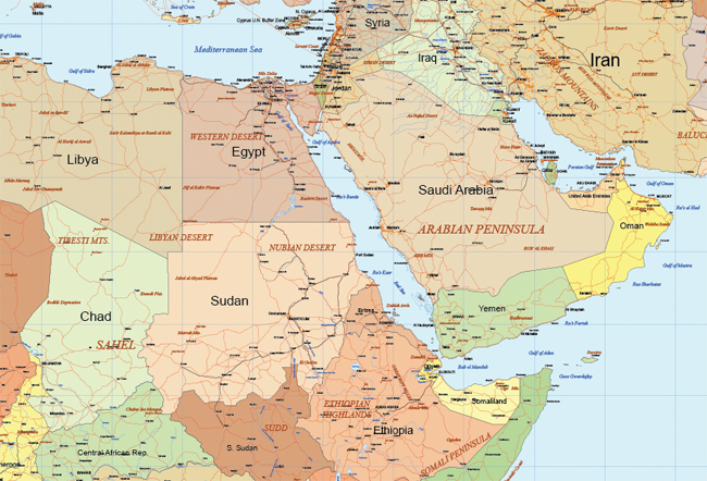
Maptorian Vector Maps

Maptorian is a vector map pack created thinking about the work of graphic designers, journalists, computer graphics and, in general, people who need to create visually appealing maps easily and quickly. Thanks to the maps distributed by layers of Maptorian, any person who knows how to handle a current vector graphic design program, especially a program like Illustrator, can easily shape their own maps.

Maptorian detail

Everything in Maptorian maps is editable. The distribution of thematic layers is designed to quickly create different types of maps through the activation and deactivation of the same, the change in distribution and, of course, in its edition. Yes, all in Maptorian is editable. The thicknesses, colors, text, fonts, everything can be changed easily to reach the desired map. And all this without leaving your favorite vector drawing program, without having to resort to complex mapping tools.

Maptorian detail

Maptorian pack maps are created thinking in graphic design in the visual, to communicate information easily. For this, there has been shaped with public domain cartographic databases, like Natural Earth, following as reference the CIA World Factbook maps, from a dumping of raw data into a GIS, later distributed in layers with Illustrator. Each vector object created this way has subsequently been edited “by hand” when the occasion demanded it, as it happened with text labels, elements of color, thicknesses and other graphic aspects. The result is a vector map pack created just to have on hand a number of ideal quality templates when designing visually appealing maps.


Read More »

Apple Announces ‘Apple Maps’ Integrated in MacOS X 10.9 ‘Mavericks’

Yesterday Apple announced that their Maps application will be integrated in MacOS X 10.9, to be available next Fall. Of course, Apple Maps was mentioned several times in the past, especially since the underlying data and search capabilities behind Apple Maps was / is not as stellar as the popular Google Maps service.

From the Apple page: "The Maps app lets you use every pixel of your display to explore new destinations, and it takes full advantage of the graphics power of your Mac. So zooming is incredibly smooth and responsive. Text and details are crisp and easy to read. And you get gorgeous views such as Flyover, a photo-realistic, interactive 3D experience that lets you soar high above select cities. Maps makes it simple to get information on local points of interest like restaurants and hotels, showing you phone numbers, photos, and even Yelp reviews. It’s also easy to get there on time, thanks to point-to-point directions, real-time traffic conditions, and suggested alternate routes. When you’re ready to go, send your map to your iPhone for voice navigation on the way.3 With OS X Mavericks, maps are built into Mail, Contacts, and Calendar, too. So wherever you see an address, you can see it on a map, just like that."

Read More »

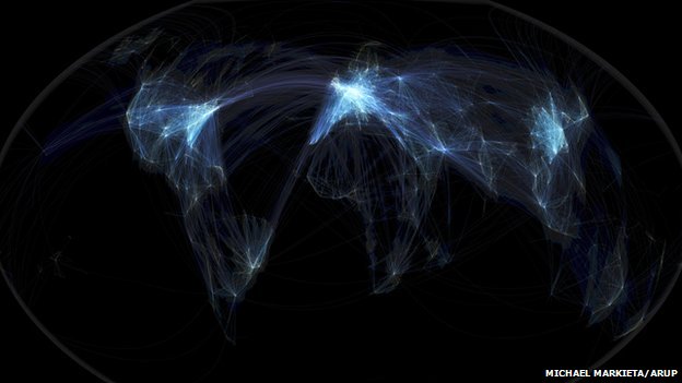
Interpreting Global Flight Maps

Slashdot discusses a story named Interpreting Global Flight Maps.

Their summary: "Five experts including: artist, environmentalist, aviation consultant, data visualization expert and philosopher interpret a flight map showing global flights. While the imagery of the visualization is intriguing, the interpretations are particularly interesting and show how individual background and experience impact they way they view the data."

It's clearly not the first time we mention airplane flights maps, we had previous stories such as Flight Paths and Noise Mapping, Near Real-time Flights over the U.S., OpenFlights database and more.

Read More »

Batch Geonews: Debacle over OGC and the GeoServices REST API Standard, OpenLayers vs Leaflet, More Geo from Google I/O, and much more

The recent geonews in batch mode, covering a larger timespan than usual.

On the open source front:

  • The OSGeo presented an Open Letter to OGC on the GeoServices REST API standard, and it's pretty well documented and informative
  • Here's an interesting entry on comparing OpenLayers and Leaflet
  • The schedule for FOSS4G-CEE is now known
  • Sean pointed me to  Tom MacWright's online GeoJSON editor
  • In releases, there was GeoServer 2.3.2 released and GeoTools 9.2 Released
  • Getting closer to QGIS 2.0, here's nice examples of the alpha channel in QGIS color ramps
  • If you did not see the press release, OpenGeo is not non-profit anymore

On the Google front:

  • The influx of Google Glass stories continues, now Facial Recognition Comes to Google Glass
  • Here's Kurt's list of maps-related videos from the Google I/O conference

On the Esri front:

  • ABP reminds us of Esri's Severe Weather Map, including tornadoes...
  • An entry on why Esri is excited about the Android Location APIs
  • Data updates, World Topographic Map updated with content for the Middle East, North Africa, and the United States
  • along with other updates, including Additional DigitalGlobe and community imagery added to the World Imagery map
  • Also updated, ArcGIS for Windows Phone and ArcGIS API for JavaScript v3.5 Released

In the everything-else category:

  • MapBox tells us they got a huge satellite update, now cloudless and with aerial imagery, but also interesting are the OpenStreetMap updates making they way to MapBox maps in only 5 minutes
  • Here's a Make article on mapping buildings with a Kinect
  • Some of you might be interested by the GiT4NMD conference, Geo-information Technologies for Natural Disaster Management
  • Space Daily share an article named World's major development banks look closer at Earth observation
  • Here's links regarding the history of apostrophes in place names
  • Via SL, an article named China's Drone Program Appears To Be Moving Into Overdrive
  • Those interested in the exciting MapBox work may also want to read about vector tiles of MapBox Streets
  • While CAD and GIS have come closer, they remain distinct, here's an entry named Integrating geospatial into construction: the challenge
  • Geoff also shares two other interesting entries, one named Economic value of big geospatial data could reach $700 billion/yr by and the other Estimating the economic and financial impact of poor data quality

Slashdot discussed a few minor geo-related stories:

  • One involving GPS named Researchers Are Developing Ad Hoc Networks For Car-To-Car Data Exchange
  • Privacy stories goes on, UK's 4G Network Selling Subscriber Tracking Data To Police, Private Parties and this one Congress Demands Answers From Google Over Google Glass Privacy Concerns
  • Along with new challenges to locating North itself, Global Warming Shifts the Earth's Poles

In the maps category:

  • Here's The Best Geographic Visualization I’ve Seen In Ages according to VerySpatial, basically a circle centered in Asia where over half of the world's population resides
  • In Paris? Apple Maps for iOS Adds 3D Flyover Coverage in Paris
  • MapBox shares a Q&A of the City Guides by National Geographic mobile app
Read More »

“The Ubiquitous Digital Map” Talk: a Quick History of the Digital Map

InfoQ have published a talk by Gary Gale (@vicchi) called "The Ubiquitous Digital Map (Abridged)" giving a half hour potted history of the digital map. Worth a watch (but not as full screen as you'll miss the slides!) as knowing where we came from might help to understand where we are going.

Read More »