Tag Archives: open source

QGIS 2.0 Released

This is major news. The popular open source desktop GIS formerly known as Quantum GIS, now simply QGIS, has released its version 2.0 at FOSS4G. This release reduces the gap with some of the mature commercial desktop GIS available. There's also QGIS 2.0 for Android in the works.

Here's the full list of what's new and changed - it's just too long to copy it all, so here's some of it:

User interface:

  • Feature: Side tabs, collapsable groups
  • Feature: Soft notifications
  • Feature: Drag and drop form builder

Data providers:

  • Feature: Oracle Spatial support
  • Feature: Web Coverage Service (WCS) provider added
  • Feature: Raster 2% cumulative cut by default
  • Feature: WMTS Support

Symbology:

  • Feature: Data defined properties
  • Feature: Support for transparency in colour definitions
  • Feature: Color Control for Raster Layers

Map composer:

  • Feature: Multipage support
  • Feature: Layer blending
  • Feature: Multicolumn composer legend

Labeling:

  • Feature: Expression based label properties

There's a lot more to it. Head to the full list to learn more and see numerous screenshots.

Read More »

Europe dotmap - 591 milion points european population density

Dear Slashgeo editor, we have released a map entitled "Europe Dotmap" which shows 591 milion points (one per person) corresponding to the european population density.

The map is obtained by merging two database sets (NASA SEDAC-Gridded Population of the World v3 and GADM-Global Administrative Areas v2) to display a simple and modern perspective of european population at municipalities level. Combining this information, the final result is a tile web map service with 6 zoom levels .

Map and more information:
worldtiledotmap
 
Sincerely,

Marc


Read More »

Public Sector moving to Open Source Geospatial

Public Sector moving to Open Source Geospatial
 

FOSS4G, Nottingham, 18th September - Astun Technology reports an ever increasing interest from the Public Sector in its Open Source Geospatial solutions. Significant contracts won in mean that Astun is now serving over 60 public sector organisations including Local Authorities, National Parks, Emergency Services and Housing Associations. Demand has led to the development of a mix of solutions stretching from public facing map portals, enterprise GIS and Spatial Data Warehouses to Cloud based data hosting. All of these are built on Open Source technologies.

The Government position on Open Source has been clear from the outset. The austerity and cost saving brought on by the world financial crisis had led to a preference for open standards for software interoperability, data and document formats. The endorsement of open source by government is based on a range of factors including capability, cost and lack of vendor lock-in. 

Astun Technology, an OSGeo sponsor founded in, has used Open Source from the beginning to underpin all of its software solutions. “Open Source has enabled us to develop on robust foundations safe in the knowledge that we are backed by a worldwide community of like minded developers,” said Mike Saunt company founder. “We don’t have to worry about restrictive vendor licensing and have the flexibility to provide our clients with real value. Whilst it is not always economic and often impractical to throw out proprietary in favour of Open Source the interoperability, issue often cited as barrier against wider adoption, just doesn’t hold water. If anything the opposite is the case; Open Source helps to set standards and acknowledges established ones. We have integrated our solutions successfully with over 60 different service delivery systems and work hard to maintain business continuity,” continued Saunt.

Cloud hosting solutions (Astun Cloud Services) are increasingly popular as authorities seek to cut their IT overhead. For GIS departments in particular, the management of spatial data and servers is now beginning to move off site and into the Cloud. Astun currently manages customer applications and the full national range of Ordnance Survey (OS) PSMA data along with OS OpenData base mapping. Astun provides feeds from other open data services too including Edubase, NHS Choices, Police UK, Land Registry Price Paid and Companies House data - all available as WFS feeds. Under the hood OSGeo technologies are hard at work. In one form or another over 100 public sector organisations are using Astun Cloud Services.

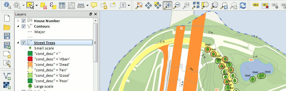
“We are finding that our public sector customers are now better informed about Open Source. The taboo that existed just a few years ago has largely melted away as organisations seek to deliver better value with solutions tailored to deliver precisely what they require,” said Mike Saunt. Even proprietary licensed Desktop GIS is taking a hit as organisations look to use open source alternatives such as Quantum GIS (QGIS). We started running training courses for PostgreSQL/PostGIS in on the back of existing customer demand and now there’s sufficient interest for us to run regular QGIS training too,” continued Saunt.


Astun Technology provides geospatial solutions built on Open Source foundations, helping organisations to realise the power of geography and corporate data in managing assets and business processes. Astun’s iShare data integration and publishing platform provides public facing geoweb applications and corporate geographic information across the enterprise and is in use with more than 60 public sector organisations including Local Government, National Parks, Emergency Services, and Housing Associations. Astun offers bespoke geospatial application development, training, mentoring and support plus a range of ‘Cloud’ services built on OSGeo Open Source Technology.


Read More »

OpenGeo Relaunches as Boundless

OpenGeo is one of the few major open source geospatial companies out there and we mention them frequently. Today OpenGeo announced that their future is not just open, it's boundless, OpenGeo is rebranding and will now be known as Boundless.

From the announcement: "With the momentum behind our company and shifts happening within the industry, we realized that we needed a new identity to better reflect where we’re headed. We also recognized that there are potential conflicts with other companies using the OpenGeo name, driving a desire for us to build a larger, more encompassing brand for our vision and products. [...] While we’ll be developing new solutions and taking on new challenges, we’re not leaving our current products behind. In fact, we’re expanding them. Our new name marks our push into new technologies, including geospatial web services monitoring with Mapmeter, desktop software with QGIS, our growing capabilities in cloud and mobile platforms, and our expanded work in data editing workflows."

Read More »

Batch Geonews: SOTM Overview, ArcGIS Online Updates, Google Earth for Teachers, and more

Here's the recent geonews in batch mode. With FOSS4G next week, I expect exciting news soon!

On the open source / open data front:

  • OpenStreetMap's State of the Map ended, here's an outsider overview, keywords: growing and healthy
  • It's been a while since we mentioned that one, New MapProxy 1.6.0 released, a reminder, "It caches, accelerates and transforms data from existing map services and serves any desktop or web GIS client"
  • GeoMoose is now officially an OSGeo project, reminder, it's an "Open Source Web Client JavaScript Framework for displaying distributed GIS data"
  • Paul shows us Census Mapping Made Easy with open software

On the Esri front:

  • Esri added Landscape Layers to ArcGIS, "over 60 layers are available at your fingertips as input to geoprocessing models and for the creation of beautiful and informative interactive web maps"
  • Here's for next Tuesday, Check Out What’s Coming in ArcGIS Online
  • Esri also introduced GeoEnrichment for JavaScript developers, which helps you "create a web app that’s full of interactive demographic, consumer spending, and lifestyle data for the viewers of your map"

On the Google front:

  • The GEB shares More great Google Earth resources for teachers
  • Google invites us to Explore the Galapagos’ biodiversity with Street View, and why not boats, Kurt shares the R/V Falkor in Street View and still on the same topic, Updated Street View imagery of tsunami-affected areas of northeastern Japan, including the exclusion zone
  • Same old story still making the news, Court Declares Google Must Face Wiretap Charges For Wi-Fi Snooping when collecting data for StreetView
  • In the trivia category, Court Orders Retrial In Google Maps-Related Murder Case
  • Nice to look at, Tri-bridges around the world, three-way bridges

In the everything-else category:

  • Bing Maps got a major imagery update, 13 Million Square Kilometers of Imagery, or 315.92 terabytes
  • Here's a beautiful 4-minutes video on the last 50 years of the satellite industry made by DigitalGlobe
  • Amazon improves its geo offerings with a New Geo Library for Amazon DynamoDB, allowing a basic set of spatial queries
  • Another way Apple Maps will improve, Apple Working to Leverage New 'M7' Motion-Sensing Chip for Mapping Improvements
  • Wired reviews the book The Lost Art of Finding Our Way by Harvard's John Edward Huth
  • An OGC entry named Smart Cities Depend on Smart Location Communication
  • Efforts mentioned before, 3 million data points collected by Safecast to warn Japan about radiation
  • Yes, the NSA knows where you've been, NSA Can Spy On Data From Smart Phones, Including Blackberry
  • Geoff has an entry on the successful use of satellite imagery to reduce illegal deforestation in Brazil
  • On GhettoTracker and segregation through geospatial knowledge, Could Technology Create Modern-Day 'Leper Colonies'?
  • When geospatial apps goes too far, New Smartphone Tech To Alert Pedestrians: 'You Are About To Be Hit By a Car', this other app might be more useful: Dangerous Neighbourhood? Kovert App Will Navigate With Vibration From Your Pocket
  • In the maps category, Wired offers links and maps on The Geography of American Agriculture
Read More »

geojson: Vector Data Edition and Sharing for Everyone

I lied, I have not yet shared all the pertinent geonews that happened during my extended holidays, I was keeping this gem just for myself, here it is! In late July, the open source geojson.oi website for drawing, changing, and sharing GeoJSON-formatted map data was announced by MapBox's Tom MacWright. This is major news in my opinion: creating and sharing basic vector geodata on a map can't be made easier and accessible. Try it out yourself.

Here's the about page. The brief initial announcement: "geojson is for drawing, changing, and sharing GeoJSON-formatted map data. Save as a GitHub Gist and share a link. Hit Cmd-S to do it quickly. Edit the JSON properties in GeoJSON features easily. Line-specific JSON-validation errors from jsonlint. Line-specific GeoJSON-validation errors from geojsonhint. Use geojson with modern mapping tools, like TileMill, MapBox.js, GitHub, and Shapely. It’s made of open source: Leaflet.draw, MapBox.js, CodeMirror, and a new library I wrote called geojsonhint, that does GeoJSON validation."

Read More »

TileServer-PHP: OGC Web Map Tiling Server (WMTS)

While we mentioned several times the WMTS OGC standard and its brother the TMS protocol, we never mentioned TileServer-PHP, an open source Web Map Tiling Server.

From the github readme: "This server distributes maps to desktop, web, and mobile applications from a standard Apache+PHP web hosting. It is a free and open-source project implementing OGC WMTS standard for pre-rendered map tiles made with MapTiler Cluster, MapTiler, GDAL2Tiles, or available as MBTiles files. It is the easiest and cheapest way how to serve zoomable maps in a standardized way - practically from any ordinary web hosting. It is easy to install - just copy the project files to a PHP-enabled directory along with your map data containing metadata.json file. It comes with an online interface showing the list of the maps and step-by-step guides for desktop GIS software [...]"

Also important, supported protocols are:

  • OpenGIS WMTS 1.0.0
  • OSGeo TMS 1.0.0
  • TileJSON.js
  • Direct access with XYZ tile requests (to existing tiles in a directory or to .mbtiles)

Read More »

Batch Geonews: TIGER, ArcGIS for WordPress, RTK GPS for $2k, Yosemite Fires, and much more

Catching up the August geonews, we're now all up to date with this way too long entry.

On the open source front:

  • The new open source GraphHopper Maps – High Performance and Customizable Routing in Java based on OpenStreetMap data (via OSM)
  • Here's Quantarctica, a free GIS package for Antarctica, the basic package is 7 gigs of free geodata and works with QGIS
  • MapBox has an entry on the US Census Bureau released the version of TIGER
  • There's more of those, the first Open Source Geospatial Lab in Switzerland is established at SUPSI, Ohio's First Open Source Geospatial lab will be established at KSU, and another one, First Australian Open Source Geospatial Laboratory at the University of Melbourne
  • Frequent improvements, GeoTools 9.5 Released, GeoServer 2.3.5 Released, and Geopaparazzi 3.6.0 is out
  • MapGuide Open Source is still alive and a major release planned for next year, meanwhile, Announcing: MapGuide Open Source 2.4.1 and 2.5.1
  • Try open source software easily, OSGeo-Live 7.0 Released

On the Esri front:

  • WordPress and Esri are both very popular, this gives us a WorldPress Plugin for ArcGIS Online: Spatial-Blogging for all Bloggers
  • Esri released ArcGIS for State Government
  • Here's an open source boilerplate for ArcGIS API for Javascript apps
  • From Esri Press, the second edition of book 'The GIS 20: Essential Skills'
  • MS and Esri, Bing Maps Use in ArcGIS Has Changed
  • Updates, ArcGIS API for JavaScript Version 3.6 Released and ArcPad 10.2 Released

Discussed over Slashdot:

  • More free data, Using Zillow's Creative Commons Neighborhood Boundary Data For the U.S.
  • Microsoft acquires a part of Nokia, including access to Nokia mapping services
  • Patents block innovation, How Patent Trolls Stalled a New Transit App
  • Mapping unhappiness, Twitter-Based Study Figures Out Saddest Spots In New York City
  • With MapBox behind, Open Source Mapping Software Shows Every Traffic Death On Earth, on a similar topic, Visualizing New York’s Road Accidents With the Interactive ‘Crashmapper’
  • Old maps, Ostrich-Egg Globe Believed Oldest To Show New World
  • More competition for driverless cars, Nissan Plans To Sell Self-Driving Cars By
  • Sharks with lasers? Great White Shark RFID/Satellite Tracking Shows Long Journeys, Many Beach Visits

In the miscellaneous category:

  • Another insightful entry from Brian Timoney, with an example of how difficult it can be to simply get the latest US state boundaries
  • Kickstarter to get a 4-cm accuracy real-time kinematic GPS for only 2,000$, named Piksi
  • OGC standards and Advancing Toward Spatial Data Quality Assurance
  • MapBox has been testing their upcoming quick access to satellite imagery 'MapBox Satellite Live'
  • Another research indicating using GPS negatively impact our internal picture of the world
  • MapQuest wants to stay relevant with their new spatially aware Data Manager API web service
  • Here's the YouSayCity, a 3D tool to discuss and document the future of individual cities
  • Not directly geospatial, Discover the World's Greatest Internet Cities
  • While it's a rather poor game, gamification of crowdsourcing geospatial data is here, this example of the Landspotting iPad app to crowdsource satellite imagery classification in a game, I preferred the Kort game to improve OpenStreetMap
  • Wired shared an article on Google Map Maker, OpenStreetMap and the State of Crowdsourced World Mapping
  • Nothing surprising, Apple too will leverage its users, iOS 7 Will Ask Users To Help Improve iOS Maps, Apple also acquired Embark to Further Improve Mass Transit Navigation
  • In-the-house mobile devices, Are Mobile Users Really Mobile? Not So Much
  • With Agile everywhere, it's Agile somewhere, 17th AGILE Conference on Geographic Information Science
  • Don't know how many people there is an in area? Use the pickle consumption index
  • Something we heard before, the geospatial identity crisis and the term 'geomatics'
  • We mentioned it in and here's an updated about Gmap4: REST and WMS Map Viewer for Google Maps and GIS Data
  • Another OGC entry, this time on big data and Big Processing of Geospatial Data
  • A generic NYT article on Microsatellites: What Big Eyes They Have
  • Drones again, Light-weight UAV-mounted laser scanning system announced
  • Future unevenly distributed, Video Flashback 1987: Star Trek's Shatner Tells You Where You Can Stick Your Maps
  • Pretty interesting, geo doesn't have to be that complex, James Fee shares GIS Is Complicated by Design

In the maps category:

  • Yosemite fires entries: The Fire Last Time: Mapping Blazes Past, Present - and Future, 6 Months of Wildfires Burning North America, and Yosemite Fire’s Destruction Mapped in Beautiful, Frightening Color
  • Another source for marine traffic, Visualize and Monitor Maritime Vessels, Real-time on Google Earth
  • Map of Nobel prizes, A visual exploration of the Nobel Prize history
  • An printed atlas, Atlas of the World Wide Web
  • Maps of war, Targeting Sites of Attack in Syria
  • Correlation is not causation, maps of Milk, the Drink of Conquerors
  • Via Wired, don't miss (really) this London’s Underground With This Mesmerizing Interactive 3-D Map
  • On a similar topic, the Interactive Map of the Paris Metro
  • A new version, the nice Submarine Cable Map
Read More »

PostGIS 2.1.0 Released

Still catching up geonews, this is a major one, the mature open source geospatial database PostGIS 2.1.0 has been released.

In short, "This release contains a ton of speed improvements, function additions , and super sexy new features. It has been over a year in the making. New functions itemized here". The highlights:

  • "More terrain analysis functions. In addition so slope and aspect calculations, there are now also roughness, Topographic Position Index and Terrain Ruggedness Index.
  • Tiling large rasters into small rasters with ST_Tile. This is useful for analyses that work best on large rasters, but are served out as results best as small tiles. The raster opposite of ST_Tile is ST_Union, which has received performance improvements in 2.1
  • New geocoding engine. The TIGER geocoder that has shipped with PostGIS for several years has been enhanced using the address normalization engine from PACG. As a result, batch geocoding is an order of magnitude faster.
  • New selectivity calculations, supporting N-D and geographic indexes, as well as improved join selectivity calculations. Will provide generally improved query planning for complex SQL.
  • Performance enhancement by up to 20x for ST_Distance calculations on geography.
  • Delaunay triangulation inside the database with ST_DelaunayTriangles.
  • Performance and functionality enhancements to ST_MapAlgebra, allowing even more crazy in-database raster analytics."
Read More »

Fiona 1.0 Released: Python OGR API

While we mentioned the Fiona a few times since, with the recent 1.0 release, here's more about it. Fiona is an open source OGR API for Python.

From the official page: "Fiona provides uncomplicated Python interfaces to functions in OGR, the best open source C/C++ library for reading and writing geographic vector data.

Fiona is designed to be simple and dependable. It focuses on reading and writing data in standard Python IO style, and relies upon familiar Python types and protocols such as files, dictionaries, mappings, and iterators instead of classes specific to OGR. Fiona can read and write real-world data using multi-layered GIS formats and zipped virtual file systems and integrates readily with other Python GIS packages such as pyproj, Rtree, and Shapely."

In the 1.0 announcement, Sean summarize what it offers:

  • Simplicity and less code.
  • Familiar Python types and protocols like files, dicts, and iterators instead of classes specific to GIS.
  • GeoJSON style feature records.
  • Reading and writing single and multi-layer files.
  • Reading zipped data, too.
  • A handy command line tool that upgrades "ogr2ogr -f GeoJSON".
  • Comprehensive tests.
  • 15 pages of narrative documentation.

And yes, Fiona is already updated to version 1.0.1.

Read More »