Tag Archives: software

FOSS4G-NA in Minneapolis May 22-24

The details of FOSS4G North America have been announced­. Everything is there, from registration, the call for presentations, the gala and the code sprint.

Amongst the keynotes they propose: "Eric Gundersen, CEO, MapBox.  With big names converting from Google Maps to MapBox (USA Today, Foursquare, etc.), Eric will be discussing the business proposition/value of open source geo.

Erek Dyskant, Sr. Analytics Engineer, Democratic National Committee. Whether you were happy or sad with the outcome of the recent election, they must have done something right!  Erek will talk about how open source solutions were used to empower tacticians with geospatial data, and describe what drove the intentional choice of using open source."

Last year, Slashgeo had the chance to be a media partner of the first FOSS4G-NA.

Read More »

OpenStreetMap: 1 Million Contributors!, Introducing OSM’s New JavaScript Editor, and OSM Editions of Year

Every frequent Slashgeo reader knows about OpenStreetMap, and now, the project reached another important milestone: 1 million OpenStreetMappers.

From the blog entry: "OpenStreetMap has just passed 1 million users! That's a million people who have signed up on openstreetmap to join in with creating a free map of the world. At first glance you may think that OpenStreetMap is a map. Those who know more will tell you that it's actually a database; a flexible editable repository of free geospatial data. But above all OpenStreetMap is a community. A massive community in which people like you and me come together collaborate and help build this thing... and now there's a million of us!"

To ease contributions even more, they also introduced the alpha version of the new OpenStreetMap editor, codenamed iD (screenshot below). And for its beauty, see the short animation on OpenStreetMap: A Year of Edits.

Read More »

Avenza Geographic Imager Adds Write Support For LizardTech MrSID Format

- MrSID export ability available with Geographic Imager 4.1 -

Toronto, ON, January 7, - Avenza Systems Inc., producers of MAPublisher® cartographic software for Adobe Illustrator® and PDF Maps for Apple iOS and LizardTech, a provider of software solutions for managing and distributing geospatial content, today announced the integration of LizardTech® GeoExpress® 8.5 and the ability to produce MrSID format files into the latest release of Geographic Imager 4.1 for Adobe Photoshop.

LizardTech, based in Seattle, WA, specializes in developing the MrSID format, which handles high-resolution geospatial data. Previous versions of Geographic Imager have already provided read capability for raster and LiDAR MrSID via the integration of LizardTech MG4 Decode Software Development Kit (DSDK). With the current release, Avenza customers can take advantage of the ability to write to MrSID format directly from Adobe Photoshop provided they have the current version of LizardTech GeoExpress installed. This ability expands the number of supported file formats Geographic Imager can write and increases workflow options when working with high-resolution imagery.

“As the leading GIS vendor to support both viewing and writing of MrSID files in Adobe Photoshop, we're excited at the opportunity to partner with LizardTech to provide our users with access to MrSID technology,” said Ted Florence, President of Avenza. “With this integration, customers on both sides will be able to use MrSID images with the entire Geographic Imager toolset without compromise. The capability of tools in Geographic Imager and Adobe Photoshop with the ability to export to MrSID format is an invaluable workflow and shows how committed we are at bringing formats to the platform that may have never been thought possible.” he added.

Jon Skiffington, director of product management at LizardTech, notes, “We're thrilled at the opportunity to work with Avenza Systems to expand the reach of MrSID technology into viable platforms like Geographic Imager for Adobe Photoshop for the benefit of our mutual users.” Additionally, Jeff Young, business development manager at LizardTech, commented, “Collaboration with Avenza allows for more effective support of the Avenza/LizardTech world-wide user community with smoother workflows and more transparent data exchanges.

More information about MrSID support in Geographic Imager is available/geographic-imager/lizardtech-mrsid.

More about Geographic Imager for Adobe Photoshop

Geographic Imager is software for Adobe Photoshop that leverages the superior image editing capabilities of raster-based image editing software and transforms it into a powerful geospatial imagery editing tool. Work with satellite imagery, aerial photography, orthophotos, and DEMs in GeoTIFF and other major GIS image formats using Adobe Photoshop features such as transparencies, filters, and image adjustments while maintaining georeferencing and support for hundreds of coordinate systems and projections.

Geographic Imager 4.1 is immediately available free of charge to all Geographic Imager Maintenance Program members and at prices starting at US$319 for non-maintenance members. Academic and volume license pricing are also available. Geographic Imager 4.1 is available for Adobe Photoshop CS5, CS5.1 and CS6. LizardTech GeoExpress licenses and data cartridges are also available through Avenza Systems.

More about Avenza Systems Inc.

Avenza Systems Inc. is an award-winning, privately held corporation that provides cartographers and GIS professionals with powerful software tools for making better maps and for working with spatial imagery. In addition to software offerings for Mac, Windows and Apple mobile device users, Avenza offers value-added data sets, product training and consulting services.

More about LizardTech

Since 1992, LizardTech has delivered state-of-the-art software products for managing and distributing massive, high-resolution geospatial data such as aerial and satellite imagery and LiDAR data. LizardTech pioneered the MrSID technology, a powerful wavelet-based image encoder, viewer, and file format. LizardTech has offices in Seattle, Denver, London, and Tokyo.


Read More »

GeoServer 2.2.3 released

The GeoServer team is happy to announce the release of GeoServer 2.2.3, now available for download.

This is the latest release of the stable 2.2 series and contains some small new features and interesting fixes:

  • [GEOS-3885] – Update Freemarker templates through REST API
  • [GEOS-5325] – Add title and abstract to LayerGroupInfo
  • [GEOS-5462] – The rendering thread can block forever under request cancellation
  • [GEOS-5479] – Error in Documentation: </PropertyName> tag used instead of </Literal>
  • [GEOS-5483] – json output in WPS extension does not work due to missing library
  • [GEOS-5485] – Border artifacts when reprojecting single banded (scientific) raster data

Also, looking at the corresponding GeoTools release changelog we have the following extra goodies in:

  • better support for chaining rendering transformations
  • fixes to time/date handling in CQL
  • Oracle specific SDO_NN function to find the N nearest objects to a given location

We also welcome our newest committer, Davide Savazzi, and thank him for the work on Freemarker template through the REST API and the title and abstract support in layer groups, as well as the SDO_NN work back in GeoTools.

Download GeoServer 2.2.3, try it out, and provide feedback on the GeoServer mailing list.


Read More »

GeoTools 8.5 released

The GeoTools community is pleased to announce the availability of GeoTools 8.5 for download from source forge

  • geotools-8.5-bin.zip
  • geotools-8.5-doc.zip
  • geotools-8.5-userguide.zip
  • geotools-8.5-project.zip

This release is also deployed to the OSGeo Maven Repository. For more information on setting up your project with Maven consult the Quickstart.

About GeoTools 8.5

This is a bug fix release containing a number of fixes and improvements, including:

  • several fixes to rendering transformations allowing several transformations to be chained together  in the same rendering request (e.g., interpolate values from discrete points and then also extract isolines from it)
  • fixes to date/time handling in CQL
  • spotted and fixed a deadlock in the rendering subsystem happening if the renderer gets abruptly stopped while working against a very fast data source (or a very slow Graphics2D implementation)
  • a new PullParser class allowing for better streaming parsing of large amounts of XML (e.g., GML, KML)
  • better handling of raster "no data" during reprojection, avoiding border artifacts in the results
  • a new Oracle specific filter function exposing Oracle spatials's K nearest neighbor search

Full details are available in Jira's release notes.

Upgrading from GeoTools 2.7

For those migrating from GeoTools 2.7, upgrade instructions are available. No additional GeoTools 2.7 released are scheduled. 

Thanks for using GeoTools, and Enjoy!
The GeoTools Community 
Read More »

Google Maps for iOS Available

Done. Google Maps for iOS has just been made available. From the official description: "Navigate your world with Google Maps, now available for iPhone. Get comprehensive, accurate and easy-to-use maps with built-in Google local search, voice guided turn-by-turn navigation, public transit directions, Street View and more. Use Google Maps to discover great places to eat, drink, shop and play, with ratings and reviews from people you trust. Sign in to save your favorite places and quickly access all your past searches and directions from your computer, right on your phone."

MacRumors offers an entry named Roundup of Features in Google Maps for iOS: Better Design than Android Version, iPad Version Coming. Which includes:

  • A horizontal two-finger swipe allows you to access a menu that shows traffic, public transit, satellite view and Google Earth (which sends you to the Google Earth app).
  • Google's point-of-interest database allows you, for example, to read a restaurant review on Zagat, read the menu, book reservations and see interior photos at 100 restaurants.
  • Pogue also notes there's a Compass Mode that allows you, at certain locations, to move your phone around and allow you to see the interior of a business on your screen.

Read More »

How to Keep Up With Changing Web Mapping Technology

Directions Mag offers an article named Research Explores How to Keep Up With Changing Web Mapping Technology, starting with 'change is inevitable: deal with it'.

From the results: "Despite the fact that the Google Maps API delivered on more of the requirements set out in the Needs Assessment Survey, the team selected Leaflet as the answer to the first question of which technology should be used for teaching. Leaflet was, in fact, second best in supporting the requirements, but the Diary Study suggested students made more progress and felt better working with that set of libraries. The team suggests that might be due to the added transparency and control provided by a fully open source library."

Read More »

Batch Geonews: OSGeo Annual Report, Cloud-Offloaded GPS, Contact Lenses AR, Geojobs Shortage, and much more

Quite a few interesting news in this batch mode edition.

From the open source front:

  • It was the first time I heard about the open source LSI Viewer, an online Shapefile viewer
  • There's the new MapProxy 1.5.0 released
  • And Portable GIS is now at version 3.1
  • It is also the first time we mention GisClient, "an open source software written in AJAX, Javascript, PHP/MapScript that offers an innovative way to manage complex GIS projects. The main strength in it is that allows to configure a big range of tools and functionalities easily and quickly."
  • If you're working with the U.S. Federal government, take a look at FedGeo Day, to be held in Washington DC on February 28, here's the official website
  • Here's the MapBox New Features Roundup
  • Regarding QGIS, visualising QGIS data in 3D with Blender and on Sharing QGIS Symbols
  • Here's the just released OSGeo Annual Report
  • A bugfix, PostGIS 2.0.2 has been released
  • And there's the call for papers and new website for FOSS4G, in the U.K. this year
  • The open source ArcGIS for Local Government Apps Available Now on GitHub

From the Google front:

  • Google announced two new features for the Google Places API: Place Photos and Radar Search.
  • Google wants us to know that they're listening to our Google Maps feedback
  • The GEB shares links for The making of the "Powers of Ten", the 1977 video
  • The GEB also reports that Botswana not happy with Google Street View, since it "compromise their security"

In the miscellaneous category:

  • APB informs us about cloud-offloaded GPS (CO-GPS) to decrease power needed by GPS devices
  • DM reports that the National Geologic Map Database Gets a Face Lift
  • We now have drones that can infect with software virus other drones
  • Here's an OGC summary of Location Business Summit USA
  • Augmented reality to the extreme, Belgian Researchers Build LCD Contact Lenses
  • Extending their offer, MapBox Teams Up with DigitalGlobe on Satellite Imagery
  • Here's the ArcGIS Online World Topographic Map December updates, and also Esri-related, Esri Updates Terms of Use on (Free) Personal Accounts for ArcGIS Online
  • On geospatial jobs, APB shares two interesting entries; NZ Report on Geospatial Skill Shortage and Four of Eight Emerging Careers for Demand Geospatial Skills

in the maps category:

  • Here's an entry named Using Series of Maps to Represent Changes in Time: How Diabetes Swept the U.S.
  • VerySpatial links to an entry and map on the geography of US charity
  • Let's end this issue with a fake map on procrasti-nation

Read More »

Geopaparazzi 3.4.0 is out! Please welcome the Spatialite brothers… and NFC support

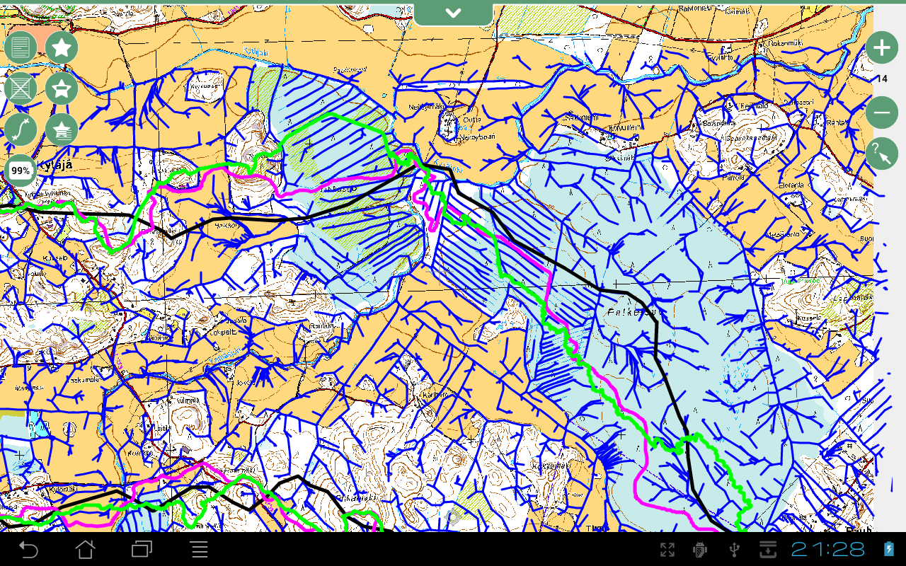
Geopaparazzi 3.4.0 has just been released to the android market. This version has one major feature: support for vector data from Spatialite databases. This opens up a new world for android based mobile devices. This is how it looks like when one uses it by overlaying a scanned Finnish orienteering map and the results of some  hydrologic/hydraulic analyses: old, new and extracted watershed boundaries and channel lines.

 
Geopaparazzi in Finland


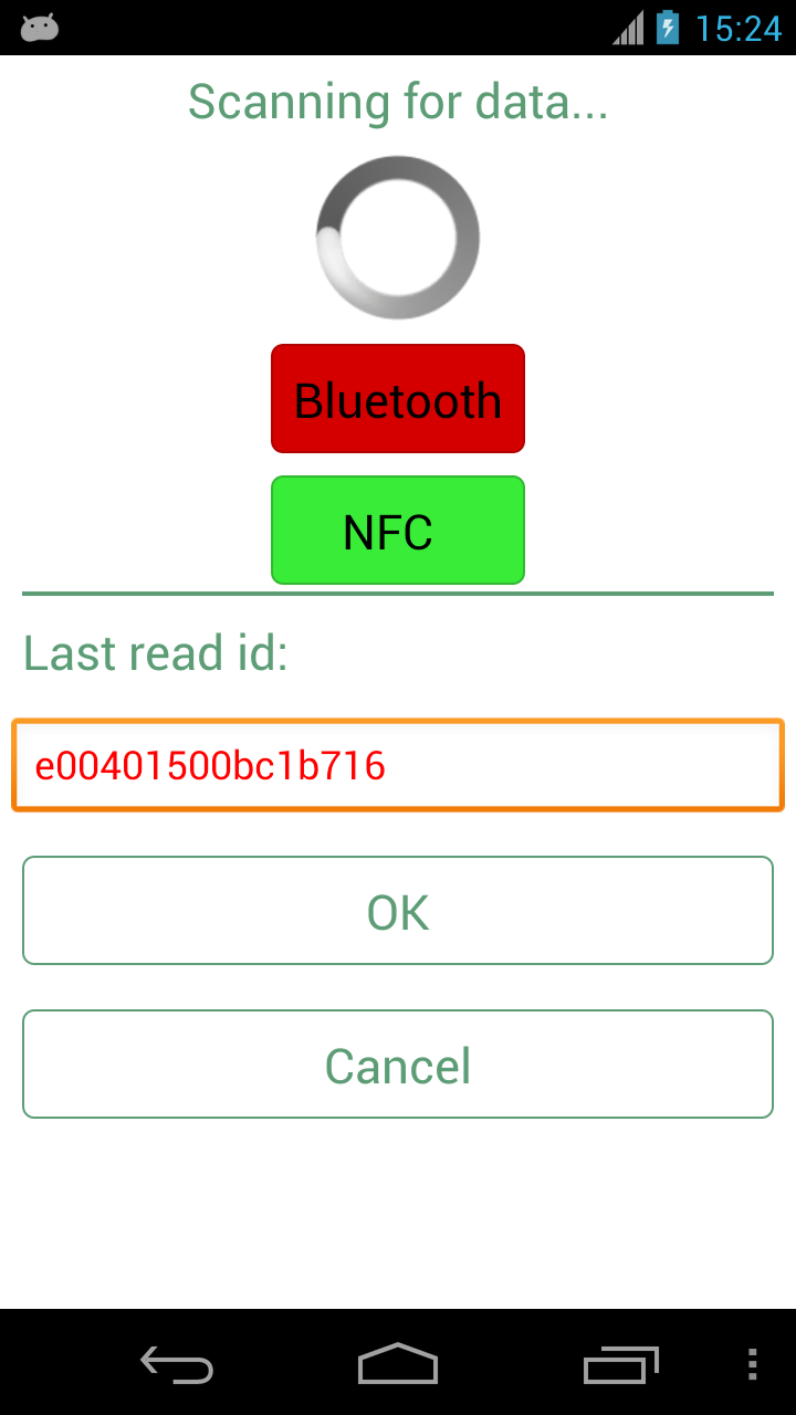
Well, the other major feature added to the release gets a bit in the shadow of Spatialite, but it might be even more important to some users: RFID tag reading in custom forms through NFC or bluetooth.

RFID scanning via NFC

If you are interested  you can read the whole story here.

Read More »

SpatiaLite 4.0 Released

Via Ecostudies I learned that SpatiaLite 4.0.0 has just been released.

Here's the warning and relevant changes related to switching to 4.0: "SpatiaLite Version 4.0.0 introduces several relevant changes; many of these may potentially pose severe cross-version compatibility issues. Accordingly to the above premise, a good comprehension of any related detail will surely allow you to successfully master and resolve any transition issue." A reminder, "SpatiaLite is an open source library intended to extend the SQLite core to support fully fledged Spatial SQL capabilities. SQLite is intrinsically simple and lightweight [...]"

See also this related discussion (read the comments) on SpatiaLite, the Shapefile of the Future? Of course, we mentioned SpatiaLite several other times.

Read More »