Related Articles
AeroGRID is now supplying wide area aerial imagery of Europe via a WMS feed to satellite image provider RapidEye AG. The high resolution imagery covers 21 European countries over nearly 4 million km².
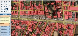
WMS is the standard protocol for streaming georeferenced map imagery over the Internet to web based applications, GIS and CAD software. WMS feeds load the imagery that a user needs to see, so it is a very convenient and efficient way for clients to subscribe to AeroGRID’s growing library of high resolution imagery. Users can confidently base their projects on AeroGRID data, which always comes with guaranteed accuracy due to long-term partnerships with well-established aerial survey companies.
“Our business requires access to precise orthophotos with an accuracy of better than 3m, and AeroGRID’s WMS service provides us with this imagery in an easy and cost effective way,” said Massimilano Vitale, RapidEye’s Chief Operating Officer.
“This contract exemplifies our core strengths” commented Miles Taylor, AeroGRID’s General Manager. “We provide unequalled wide area coverage for our clients with unparalleled accuracy and are playing a leading role in the development and wider adoption of WMS amongst the GIS community.”
About AeroGRID
AeroGRID is a one-stop-shop for international archived aerial imagery providing speedy access to aerial photography from over 60 countries with off-the-shelf high resolution satellite orthophotos for many others. By marshalling an impressive network of partner’s survey aircraft and high resolution digital cameras AeroGRID is able to extend coverage around the world. AeroGRID’s WMS servers provide instant access to orthophotos for 14 million km² from 23 countries in Europe, America and Africa with more countries added every month.
About RapidEye
RapidEye is a leading provider of high-resolution satellite imagery. With a constellation of five Earth Observation satellites, RapidEye is able to image up to five million square kilometers of earth every day, and adds over one billion square kilometers of imagery to its archive every year. Online searching and viewing of its collection is quick and easy with EyeFind, RapidEye's archive discovery tool.