Tag Archives: 3D

Hurricane Sandy: Tracking the Storm, Crisis Response Maps, Sandy in 3D, and More

Here's a last minute entry on what you'll find about Hurricane Sandy on the geoblogs.

  • Yesterday Google published New Crisis Response maps feature preparedness information for Hurricane Sandy, which includes:
    • Location tracking, including the hurricane’s current and forecasted paths, courtesy of the NOAA-National Hurricane Center
    • Public alerts, including evacuation notices, storm warnings, and more, via weather and earthquake.usgs
    • Radar and cloud imagery from weather and the U.S. Naval Research Laboratory
    • Evacuation information and routes
    • Shelters and recovery centers will appear as they become operational
    • Storm footage and storm-related YouTube videos, curated by Storyful
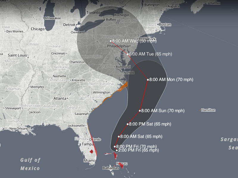
  • MapBox offers two different examples of how you can use open source tools and open data from the U.S. National Hurricane Center (NHC) to visualize Hurricane Sandy’s projected path over the next five days
  • The ESA also cares about Sandy, NASA's TRMM Satellite Analyzes Hurricane Sandy in 3-D
  • The GEB ofers some basic information on viewing Hurricane Sandy in Google Earth and APB offers some more links

It's obviously not the first time we talk about hurricane data and maps. From MapBox:

Read More »

Betaville - Collaborative Urban Design

On my morning commute I read about Betaville - "an open-source multiplayer environment for real cities, in which ideas for new works of public art, architecture, urban design, and development can be shared, discussed, tweaked, and brought to maturity in context, and with the kind of broad participation people take for granted in open source software development."

From what I read it seems to provide a platform for any interested party to provide a model of their urban design and see how it fits within the surrounding environment. It also supports discussion and collaboration between parties so potentially multiple iterations of a design can be undertaken (at a low cost) before the formal planning and design process begins. It can take models from tools such as Sketchup and Maya.

Read More »

NZ Company Plans to Map Country’s Streets in 3D

A news article describes the plans of a New Zealand company, Terralink International Ltd, to capture all of the streets in the country in 3D using a vehicle mounted with a LIDAR device.

[Editor's addition] From the article: "Unlike Google, Terralink won't be giving away all its StreetCam3D street-scape for free online. Some footage may go on the web, for example to help people research homes through its property information website Zoodle.co.nz, but Terralink hopes to sell much of the data it collects to the likes of utilities and local government - for example to help plan the $3.5 billion ultrafast broadband network."

Read More »

Batch Geonews: Marble 1.4 for Windows, Traffic for 130 New U.S. Cities, Seattle and Denver in New 3D, Georeferencing Photos, and more

You guessed it, that's the last 'batch geonews' entry for the next two weeks. This edition is much shorter than usual. 

From the open source front:

  • The open source virtual globe Marble 1.4 has been released for MS Windows
  • On scalability, Troubleshooting large GeoServer deployment

From the Google front:

  • Nothing less than 130 smaller U.S. cities now with traffic on Google Maps, along with additions and improvements elsewhere
  • Expect cities added to the new Google 3D display mode on a regular basis, this time, fly through Seattle and Denver with new 3D imagery on Google Earth for mobile
  • Google Map Maker spreading, add your knowledge to the Poland and Ukraine maps (you know me, I am going to tell you you can also add it to OpenStreetMap ;-)
  • Kurt shares two short entries on MSL/Curiosity in Google Mars and Gale Crater - Mars Science Laboratory / Curiosity

In the miscellaneous category:

  • A demonstration of how things can be easy nowadays, a DM article named Georeferencing on a Budget: Using iPhone and Freeware Apps to Geotag a Mountain of Image Files
Read More »

OpenBuildingModels Repository Beta Launched

Modelling our world in 3D gets more and more important within the OpenStreetMap (OSM) project. There are several people in the community trying to push forward this development. A major problem is that OSM was not really designed for complex 3D modelling. The node/way/relation + tags based data model does not allow for complicated 3D modelling. Therefore, the community agreed to make use of external repositories containing more complex data which can be linked to OSM.

OpenBuildingModels is such a repository for complex architectural 3D building models. It is free-to-use and aims to improve crowdsourced 3D city models. Anyone can up- or download the models. They can be referenced in OSM and appear on the OSM-3D globe. A first beta version of the web platform is now online and models can be uploaded.

Read More »

Google Geonews: Google Earth for iOS 7 Released, Europe Maps Updated, More Landsat Imagery, London Olympics, and more

Here's the recent Google-related geonews.

From official sources:

  • My iPad 2 invited me to update iOS's Google Earth to version 7: "With today’s release of Google Earth for iOS you can literally fly through breathtaking 3D city landscapes and images and follow virtual tours of places you’ve never been [...] The growing list of 3D cities include Boulder, Boston, Charlotte, Lawrence (Kan.), Long Beach (Ca.), Los Angeles, Portland (Ore.), San Diego, Santa Cruz, Tampa, Tucson, and the San Francisco Bay Area (including the Peninsula and East Bay) as well as Rome, Italy. [...] Also new in this release is a “tour guide” to show you interesting places to explore." This topic is discussed at Slashdot in a story named Google Outs 3D Maps For iOS Ahead of Apple.
  • Google also announced more detailed maps in parts of Europe, Africa and Asia: "And today, we’re launching updated maps of Croatia, Czech Republic, Greece, Ireland, Italy, Lesotho, Macau, Portugal, San Marino, Singapore and Vatican City to do just that."
  • As part of the 40th anniversary  of the Landsat satellite program, Google now includes more Landsat imagery: "We’re working with the USGS and Carnegie Mellon University, to make parts of this enormous collection of imagery available to the public in timelapse videos of the Earth's surface. With them you can travel through time, to see the transformation of our planet."
  • There's new additional panoramic imagery of historic Antarctic locations
  • Google also shared an entry named Maps for good: Google Earth Outreach Developer Grants

From other sources:

  • The GEB shares an entry on exploring the London Olympics in Google Earth
  • The same source mentions 'Google Earth Studio', a tool for the media, in an entry on Google Earth's relevance for news
  • The GEB also shares an entry on exploring fake deserts of the world in Google Earth
  • Slashdot ran a discussion named Ox Bow Lake Formation, As Seen By the Google Earth Time Machine
  • Tens of sources mentioned that Marissa Mayer, Google's former vice president of Local, Maps & Location Services was appointed CEO of Yahoo
Read More »

3D Data Ethics Charter

While we briefly mentioned it in May, it's only during recent dealings with a geomatics division of a municipality that I learned further about the 3D Ethics Charter.

Here's the Why a charter: "The third dimension (3D) undoubtedly represents a major breakthrough in terms of public policy tools. This concerns both land management on a day-to-day basis as well as the understanding of development projects, consultation between local authorities, councilors and the local population and above all helps in decision-making.

This subject relates to institutional players (public and part public authorities) and several industry bodies: architects, surveyors, engineers, town planners and landscapers. It is advantageous, for all those dealing with 3D, that all data used in preparing a representation of the "site" satisfies a certain number of demands accepted by all parties. For public authorities in particular, it is inconceivable for communication or consultancy material to be used that only corresponds partially to the reality of the site and its integration into the highway infrastructure, the urban fabric and the landscape."

The 3 principles of the Charter:

  • Principle of credibility
  • Principle of transparency
  • Principle of 3D network development and training
Read More »

Google Geonews: My Tracks 2.0, Biking Directions in Europe, Indoor Maps in Museums and in the UK, 11,000 Tours, and more

Here's the recent Google-related geonews. From official sources:

  • Google announced the release of My Track 2.0, the open source app on Android to generate GPS/GNSS tracks and share them in Google Maps and Google Earth
  • Biking directions in Google Maps expands to several countries in Europe and Australia, a topic also discussed on Slashdot
  • In the latest Google Earth for Android (and upcoming for iOS), they included a new tour guide feature for visual trips using the great new 3D imagery they are adding. There is 11,000 tours available covering 110 countries!
  • California's National Parks are now available in Street View
  • Walking directions made its way in Google Maps for Africa
  • In the latest Google Maps for Android, you now get indoor maps of 20 popular museums, added to the 10,000 other indoor maps they already provided
  • Related, there's an entry on going indoors at locations across the United Kingdom
  • There is new 45° imagery available for 31 cities including 26 cities in the U.S. and 5 international locations
  • Google also offers an entry on Map Makerpedia, their community tool for Google Map Maker (but you already know I prefer OpenStreetMap, for openness reasons)
Read More »

Google Geonews: Google Dev Glasses Available, Google Earth for Android 7 Released with 3D Cities, and more

Here's recent Google-related geonews, with some pretty interesting.

  • While there's a new uninformative official entry on Project Glass, their augmented reality glasses we mentioned in April, Slashdot provides more information in this entry named More Details On Google Glass, including: "As we mentioned earlier, the developers at I/O have the option to buy the 'Explorer Edition' of Google Glass for $1,500. In addition to the (functional, but unfinished) device itself, they also get access to Google's engineers and to keep up with the devices development. Worry not: when the consumer version of the device is finalized, it will be cheaper, but of course they aren't ready to talk about actual prices yet. As for availability: "Less than a year after we get these Explorer Editions out.""

From official sources:

  • A new Google Earth for Android version is out, with new 3D cities imagery, yes, that's the new great city imagery similar to what Apple Maps will provide with iOS 6, and Google will soon provide a new  iOS version of Google Earth too. The other major feature is the 'Tour guide': "We’ve put together short tours of thousands of famous places and historical sites across the globe so it’s easier than ever to discover amazing places." Here's which cities have the new 3D imagery: "Boulder, Boston, Charlotte, Lawrence, Los Angeles, Long Beach, Portland, San Antonio, San Diego, San Francisco, Santa Cruz and Tampa in the United States, along with Rome, Italy."
  • The Dev blog announced that Public transit routing and layer now are now available in the Google Maps API
  • It was announced and it's now reality, you can now Go offline with Google Maps for Android
  • And because we need to seriously take care of our home, Planet Earth, Google shares Geo in Rio: Cool Tools for a Warming Planet, and another related official entry is about Crowdsourcing Forest Monitoring
  • The official Dev blog shares an entry on symbols and heatmaps for the Google Maps API
Read More »

Open Source 3D ‘Point Cloud Library’ and Open Perception Foundation

Via the OSGeo Discuss list I learned about OpenPerception, an independent non-profit foundation, focused on advancing the development and adoption of open source software for 2D and 3D processing of sensory data. Currently the main output of the foundation is the open source Point Cloud Library.

On the Point Cloud Library: "The Point Cloud Library (PCL) is a standalone, large scale, open project for 3D point cloud processing. The PCL framework contains numerous state-of-the art algorithms including filtering, feature estimation, surface reconstruction, registration, model fitting and segmentation, as well as higher level tools for performing mapping and object recognition."

On Open Perception itself: "We are an independent organization created with the purpose of supporting the development, distribution, and adoption of open source software for 2D/3D processing of sensory data, with applications in research, education, and product development."

Read More »