Tag Archives: 3D

Batch Geonews: Predictions, Near Real-Time Imagery of Earth, Location Privacy, LiDAR Formats, and much more

The first batch geonews edition!

On the open source / open data front:

  • An informative update on the OGR OpenFileGDB driver to read Esri's file geodatabase format
  • Plugin to display QGIS 2D maps in 3D in a web browser via three.js
  • Interesting predictions and trends, Juan Marin’s Predictions for and Paul Ramsey’s Predictions for and MapBrief Geo Predictions
  • We never mentioned the open source data portal software before, but it supports geospatial data pretty well
  • Via OR, MapGive — U.S. State Dept launches OpenStreetMap contributing tool “to help humanitarian efforts”, and the State of the Map will be held in Buenos Aires
  • Some software updates, MapGuide Maestro 5.1, Geopaparazzi 3.9.0 is out, SAGA 2.1.1 released, Mapbox.js v1.6.0
  • Using open source software to answer Will the sun shine on us?
  • Talking of the sun, News from Marble: Introducing Sun and the Moon and Planets

On the Google front:

  • Really worth taking a look to Climate Viewer 3D: The Google Earth Climate Change, Pollution and Privacy Viewer
  • A new book, Google Maps JavaScript API CookBook
  • Viewing the Topography of the Thermohaline Circulation of the Oceans in Google Earth
  • There's New 3D imagery in Tokyo and other Japanese cities
  • From Slashdot. Google Removes "Search Nearby" Function From Updated Google Maps
  • Why not, Creating artwork based on Street View
  • If genealogy is within your interests, Genealogy through Google Earth

On the Apple front:

  • Description of an Apple Maps App with Interactive Data Layers Detailed in New Patent
  • Will this concept catch up? Apple's iBeacon Technology Brings New Possibilities for Location-Based Gaming
  • Nokia's HERE not popular enough? Nokia Pulls 'HERE' Maps App for iOS, Citing iOS 7 Changes That 'Harm the User Experience'

Discussed over Slashdot:

  • Yes, this is coming, Swarms of Small Satellites Set To Deliver Close To Real-Time Imagery of Earth another related entry is named Planet Labs to capture near-continuous whole-Earth imagery from 28 five kilogram satellites
  • If you're a regular Slashgeo reader, you know this already, Why the World Needs OpenStreetMap, and it's time to migrate 'en masse' according to The Guardian
  • On privacy, It's Not Just the NSA: Police Are Tracking Your Car
  • But you know what? Carmakers Keep Data On Drivers' Locations From Navigation Systems
  • And here's a confirmation, Ford Exec: 'We Know Everyone Who Breaks the Law' Thanks To Our GPS In Your Car
  • But there's always hope? Recent Federal Trade Commission (FTC) Settlement Will Make It Harder to Collect and Share Geoinformation In US
  • First step before commercial drones, Feds Announce Test Sites For Drone Aircraft
  • For fun, CES: Building Self-Guiding Lego Robots for Fun and (Maybe) Profit (Video)
  • There are still wonders to discover, thanks to geo, Lasers Unearth Lost 'Agropolis' of New England
  • Tracking bees, Scientists Glue Sensors To 5,000 Bees In a Bid To Better Understand Them

In the everything else category:

  • A geodesy dream? Affordable Arduino-Compatible Centimeter-Level GPS Accuracy
  • Using LIDAR data? Read Format Wars Episode V: LIDAR, why? Esri Launches its Own Propriety Compressed LiDAR Format: .zlas
  • An article on Spike, creating 3D models of buildings and things with a smartphone, not the first app of that kind but that one comes from a GIS company
  • Free map online course from Coursera to begin in April
  • You already know what IFTTT recipes are? Here's you'll learn about geoenabling triggers with geofences and more
  • Here's about SenseFly, a drone for taking oblique imagery
  • A generic entry on the Cocktail of Technologies for Smart Cities: The role of Geospatial Tech
  • Wired on Tracking the Secret Lives of Great White Sharks
  • Let's talk about our privacy again, DARPA’s 1.8 gigapixel ARGUS-IS: The Ultimate Surveillance System from above?, that's 1.8 gigapixels and 12 frames/second, 24/7
  • On the SPOT remote sensing satellite family, up to SPOT 7, The new SPOTs
  • On 3D printing, yup, really mainstream now, Adobe Adds 3D Printer Support To Photoshop and here's about the open source ' slic3r ' — converts a digital 3D model into printing instructions for your 3D printer (via OR)

In the maps category:

  • On mapmaking, The Hidden Meanings of Maps: Design and Colors
  • Beautiful, A woodcut inspired map for city streets
  • Jonathan provides a book Review: A History of the World in Twelve Maps
  • And here's A look at twelve maps that changed the world
  • Don't we all like beautiful maps? Wired shares The Most Amazing, Beautiful and Viral Maps of Year
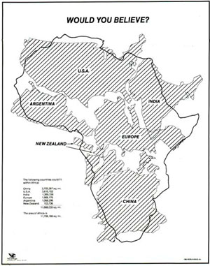
  • Here's a map you have to see, would you believe how big is Africa? Mercator projections are messing with our perception of the world
Read More »

Poppy 3D: $60 3D Stereoscopic Camera and Viewer

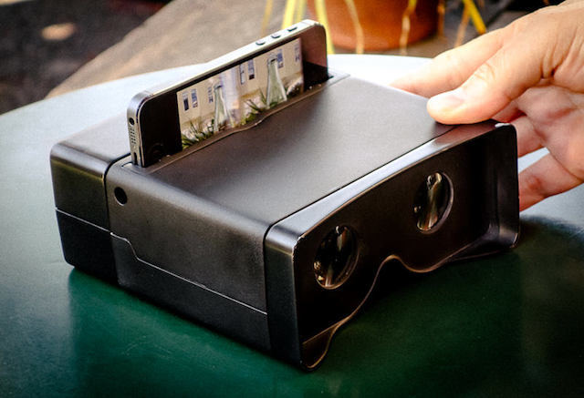
Tidbits made me aware of Poppy 3D, a very affordable box that turns your iPhone into a 3D camera and I thought this is of interest for geospatial-related usage.

Tibtibs' summary: "The first magic gizmo I saw accomplishes its wonders with mirrors, if not smoke. The Poppy from Hack Things converts any iPhone 4 or later (or fifth-generation iPod touch) into a 3D stereoscopic camera and viewer. Slot your iPhone into the Poppy, and rotate the outer portion of the Poppy 180 degrees to take two side-by-side videos or photos from slightly different vantage points. Then rotate it back to convert the camera into a viewer and watch your video in 3D. Anyone who grew up with a View-Master (still going after 70 years!) will feel a twinge of nostalgia upon using a Poppy. The Poppy is available from Hack Things for $59."

Read More »

Batch Geonews: Esri’s FileGDB Reversed-Engineered, China to Rent 5% of Ukraine, U.S. Government Shutdown Map, and much more

The recent geonews in batch mode:

From the open source / open data front:

  • At the beginning of the month, followers of Slashgeo's Twitter feed learned right away about the announcement by the City of Montreal that they'll make their textured 3D buildings publicly available in OGC's CityGML format later this Fall - this was announced at the Geomatics event - I'm waiting for a link to share for a full story (they showed impressive fly-troughs), and as far as I'm aware, that's the first major city to provide detailed textured 3D building to the public, is that right?
  • The 20-minutes video of Paul Ramsey's closing session of FOSS4G, on Being an open source citizen, well worth watching
  • Using a drone and open source software to make an image mosaic of mountains
  • Users of the R open source statistics software, mapmap 0.7 released: "Import, plot and analyze bathymetric and topographic" data
  • Here's about using CSS instead of the SLD standard to style layers in GeoServer

From the Esri front:

  • There has been a GDAL/OGR driver for the Esri File Geodatabase since January, but what's new is that the FileGDB format is being reversed-engineered, which opens the door for deeper support than what the API provides
  • Updated, Esri Maps for SharePoint 3.0.1 Released and why not, Esri Maps for Office 2.1.1 Released

From the Google front:

  • Google offers a New Google Maps preview, which includes directions for multiple destinations, your reservations, upcoming events and more
  • This may interest some of you, A Google Earth Exercise for Biblical Geography

In the miscellaneous category:

  • Interesting, James Fee on remaining relevant as a GIS professional
  • Via VerySpatial, I learned about the article named China 'to rent five per cent of Ukraine'
  • We mentioned Semantic Mediawiki since, here's a fresh article named Semantic MediaWiki: A promising platform for the development of web geospatial crowdsourcing applications
  • Can you believe them? NSA Abandoned Project To Track Cell Phone Locations
  • Location tracking is getting more insidious with an accuracy of 10cm through walls without any transmitter, MIT Develops "Kinect of the Future"
  • Yes, you can even do that, Satellite Maps Reveal Who’s to Blame for the Sinking of Venice
  • A reminder, What four things do map projections distort?
  • Locating things matter, The Internet of Things will be a $1.9 Trillion business by
  • With all the NSA / spying / privacy stories, not surprising to hear Germany Announces Rules on Sale of Commercial High Resolution Imagery

In the maps category:

  • A former colleague shared an interesting collection of 40 Maps That Will Help You Make Sense of the World
  • A Map By Nokia Shows All Windows Phones With Language Set To “Chinese” In Asia And Europe
  • A map named Roads of Death, mapping road accident deaths per country
  • For the U.S., a New York Times “Immigration Explorer” Interactive Map
  • In New York? Lower Manhattan Growth Animation (1840-2020)
  • Oh, but you might currently be more interested by the Government Shutdown Map by the Washington Post
  • Still U.S.-related, via APB, BitLy's Media Map
Read More »

Batch Geonews: TIGER, ArcGIS for WordPress, RTK GPS for $2k, Yosemite Fires, and much more

Catching up the August geonews, we're now all up to date with this way too long entry.

On the open source front:

  • The new open source GraphHopper Maps – High Performance and Customizable Routing in Java based on OpenStreetMap data (via OSM)
  • Here's Quantarctica, a free GIS package for Antarctica, the basic package is 7 gigs of free geodata and works with QGIS
  • MapBox has an entry on the US Census Bureau released the version of TIGER
  • There's more of those, the first Open Source Geospatial Lab in Switzerland is established at SUPSI, Ohio's First Open Source Geospatial lab will be established at KSU, and another one, First Australian Open Source Geospatial Laboratory at the University of Melbourne
  • Frequent improvements, GeoTools 9.5 Released, GeoServer 2.3.5 Released, and Geopaparazzi 3.6.0 is out
  • MapGuide Open Source is still alive and a major release planned for next year, meanwhile, Announcing: MapGuide Open Source 2.4.1 and 2.5.1
  • Try open source software easily, OSGeo-Live 7.0 Released

On the Esri front:

  • WordPress and Esri are both very popular, this gives us a WorldPress Plugin for ArcGIS Online: Spatial-Blogging for all Bloggers
  • Esri released ArcGIS for State Government
  • Here's an open source boilerplate for ArcGIS API for Javascript apps
  • From Esri Press, the second edition of book 'The GIS 20: Essential Skills'
  • MS and Esri, Bing Maps Use in ArcGIS Has Changed
  • Updates, ArcGIS API for JavaScript Version 3.6 Released and ArcPad 10.2 Released

Discussed over Slashdot:

  • More free data, Using Zillow's Creative Commons Neighborhood Boundary Data For the U.S.
  • Microsoft acquires a part of Nokia, including access to Nokia mapping services
  • Patents block innovation, How Patent Trolls Stalled a New Transit App
  • Mapping unhappiness, Twitter-Based Study Figures Out Saddest Spots In New York City
  • With MapBox behind, Open Source Mapping Software Shows Every Traffic Death On Earth, on a similar topic, Visualizing New York’s Road Accidents With the Interactive ‘Crashmapper’
  • Old maps, Ostrich-Egg Globe Believed Oldest To Show New World
  • More competition for driverless cars, Nissan Plans To Sell Self-Driving Cars By
  • Sharks with lasers? Great White Shark RFID/Satellite Tracking Shows Long Journeys, Many Beach Visits

In the miscellaneous category:

  • Another insightful entry from Brian Timoney, with an example of how difficult it can be to simply get the latest US state boundaries
  • Kickstarter to get a 4-cm accuracy real-time kinematic GPS for only 2,000$, named Piksi
  • OGC standards and Advancing Toward Spatial Data Quality Assurance
  • MapBox has been testing their upcoming quick access to satellite imagery 'MapBox Satellite Live'
  • Another research indicating using GPS negatively impact our internal picture of the world
  • MapQuest wants to stay relevant with their new spatially aware Data Manager API web service
  • Here's the YouSayCity, a 3D tool to discuss and document the future of individual cities
  • Not directly geospatial, Discover the World's Greatest Internet Cities
  • While it's a rather poor game, gamification of crowdsourcing geospatial data is here, this example of the Landspotting iPad app to crowdsource satellite imagery classification in a game, I preferred the Kort game to improve OpenStreetMap
  • Wired shared an article on Google Map Maker, OpenStreetMap and the State of Crowdsourced World Mapping
  • Nothing surprising, Apple too will leverage its users, iOS 7 Will Ask Users To Help Improve iOS Maps, Apple also acquired Embark to Further Improve Mass Transit Navigation
  • In-the-house mobile devices, Are Mobile Users Really Mobile? Not So Much
  • With Agile everywhere, it's Agile somewhere, 17th AGILE Conference on Geographic Information Science
  • Don't know how many people there is an in area? Use the pickle consumption index
  • Something we heard before, the geospatial identity crisis and the term 'geomatics'
  • We mentioned it in and here's an updated about Gmap4: REST and WMS Map Viewer for Google Maps and GIS Data
  • Another OGC entry, this time on big data and Big Processing of Geospatial Data
  • A generic NYT article on Microsatellites: What Big Eyes They Have
  • Drones again, Light-weight UAV-mounted laser scanning system announced
  • Future unevenly distributed, Video Flashback 1987: Star Trek's Shatner Tells You Where You Can Stick Your Maps
  • Pretty interesting, geo doesn't have to be that complex, James Fee shares GIS Is Complicated by Design

In the maps category:

  • Yosemite fires entries: The Fire Last Time: Mapping Blazes Past, Present - and Future, 6 Months of Wildfires Burning North America, and Yosemite Fire’s Destruction Mapped in Beautiful, Frightening Color
  • Another source for marine traffic, Visualize and Monitor Maritime Vessels, Real-time on Google Earth
  • Map of Nobel prizes, A visual exploration of the Nobel Prize history
  • An printed atlas, Atlas of the World Wide Web
  • Maps of war, Targeting Sites of Attack in Syria
  • Correlation is not causation, maps of Milk, the Drink of Conquerors
  • Via Wired, don't miss (really) this London’s Underground With This Mesmerizing Interactive 3-D Map
  • On a similar topic, the Interactive Map of the Paris Metro
  • A new version, the nice Submarine Cable Map
Read More »

Batch Geonews: 89% Use Google Maps, New Google Maps UI and iPad app Available, Esri UC Round Up, and much more

Here's the recent geonews in batch mode. Several interesting bits in there that may have deserved a full entry, but it's Summer time and I'm on holidays :-)

On the open source / open data front:

  • Remember Maki, the open / free cartography symbols? Maki got significantly improved and even gets an API
  • Announced, OpenGeo dives deeper into QGIS, along with the OpenGeo Suite 3.1 release
  • Jody shares his experience on OSGeo and LocationTech software foundations and their different cultures
  • Getting closer, OpenLayers 3.0.0-alpha.3
  • A success story in the Netherlands, Open standards open source projects for sharing geodata among provinces saves €4.5 million
  • A book review of 'Interactive Map designs with Leaflet JS Library How-to' by Jonathan Derrough

On the Esri front:

  • Lots of Esri news in the Round Up of Directions Magazine Esri UC Coverage 
  • A popular template, Map Tour story map template updates
  • James goes on with ArcGIS for Minecraft this time
  • Overview for Using the power of Amazon EC2 to build ArcGIS Server map caches

On the Google front:

  • Bang! 89% of websites that use mapping technologies use Google, while that may not be the exact figure, it does mean something
  • The new Google Maps interface is available to all, but you still have to opt-in, it's *really* an improvement
  • I'm amongst the happy ones, The new Google Maps app for iPhone and iPad is here
  • This goes along with the SDK version 1.4, Street View, indoor maps, and an updated map design in the Google Maps SDK for iOS
  • Jumping in, Google joins LocationTech
  • Indoor mapping everywhere, Where are we going to eat? See inside before you decide!
  • New places, On top of Mt. Fuji with the Street View Trekker and Scaling the heights of the Eiffel Tower
  • Still on a parallel track of OpenStreetMap, Growing the Google Map Maker community in Europe
  • And today, there is new imagery again

Geonews discussed over Slashdot:

  • Cheer up, Spatial Ability a Predictor of Creativity In Science
  • Another one, Disney Algorithm Builds High-Res 3D Models From Ordinary Photos
  • 3D printing for the masses, eBay Dips Toes Into 3-D Printing Market With iOS App
  • In case your weren't certain, U.S. DOJ: We Don't Need a Warrant To Track You
  • If you have a car, you can be tracked, "Smart Plates" Could Betray California Drivers' Privacy
  • And why not, ACLU Study Says Police Cameras Create Database of Our Movements
  • But some good news, Texas School District Drops Embattled RFID Student IDs; Opts For Cameras
  • Unsurprisingly, New Android Eyewear Wants To Compete With Google Glass
  • We mentioned what3words before, and now over Slashdot, Describe Any Location On Earth In 3 Words
  • What's in an Interactive Nukemap, Now In 3D

In the miscellaneous category:

  • Exposing online devices, Shodan lets you search and find the physical locations of online devices
  • On Apple, Apple Acquires Locationary to Address Location-based Big Data and Acquires HopStop for public transit  ... and according to Slate,  Apple's Maps Strategy Is Working Just Fine
  • An interesting discussion on mapping millions of dots and making great maps out of it
  • Via OR, an architecture book and design book named Operative Design: A catalogue of spatial verbs
  • OR shares a interesting quote: "We’re all carrying little networked laboratories in our pockets. You see a photo. I see millions of light-sensor readings at an exact coordinate on the earth’s surface with a time resolution down to the millisecond. The future is combining all these signals into new ways of understanding the world, like this real-time stream of atmospheric measurements."
  • BIM is there to stay? 71% of AEC professionals in annual UK survey see BIM as the future and Widespread adoption of BIM by national governments

In the maps category:

  • This was a hot topic in the U.S. recently, Mapping the Trayvon Martin murder case
  • Maps of Global Patterns of Tobacco-Related Economic Issues and another one on tobacco consumption
  • O'Reilly shares an Interactive map: bike movements in New York City and Washington, D.C.
Read More »

Batch Geonews: New Google Maps App, 3D Printing in Windows 8.1, GeoServer Enterprise, MapBox Real-time Satellite Imagery, and much more

Here's the geonews in batch mode. Some of them may have deserved their own entry.

On the open source / open data front:

  • OpenLayers 2.13.1 has been released, but arguably more exciting is OpenLayers 3.0 - alpha.2, they're getting closer
  • W3C is Launching the Open Data Directory
  • Introducing GeoServer Enterprise, it's GeoServer with long term support releases and more
  • Here's the FOSS4G-CEE Bucharest, Romania final thoughts
  • Montreal's public transport organization adopted OpenStreetMap for their maps, another example of how mature enough OSM has become
  • Nokia uses the open source CartoDB to show off traffic data
  • Good news, California Supreme Court Says GIS Data are Public Data

On the Esri front:

  • It was the Esri User Conference this week, you can read Geoff's 3D and other themes of this year's conference entry
  • Jack Dangermond explaining How Esri Hit $912 Million in Sales, very interesting, including: "One thing that has made us so successful is that we've never taken outside investment. That means we can concentrate on what our customers want--not what the stockholders or the VCs want. That's a strategic advantage."
  • You'll find a lot lot more on the Esri blog for the International User Conference
  • New imagery for Esri tools, DigitalGlobe and community imagery added to the World Imagery map
  • ArcGIS Online just got more advantageous, Get More with ArcGIS Online – Announcing Subscription Savings

On the Google front:

  • Google announced their new Google Maps app for smartphones and tablets
  • Also over Slashdot, Google Updates Maps, Makes First Stable Chrome Release Using WebKit Fork
  • Rest reassured, the iOS Enhanced Google Maps App with iPad Support 'Coming Soon'
  • Unsurprisingly, there was New Google Earth Imagery – July 8

Geo-related news discussed over Slashdot:

  • Microsoft Reveals Its 3D Printing Strategy For Windows 8.1
  • 3 GLONASS-M GNSS satellites destroyed, Russian Rocket Proton-M Crashes At Launch
  • MapBox is aiming at nothing less than Real Time Imagery via MapBox Satellite Live
  • But that's clearly the beginning, read APB's entry named Real-Time Data is Really Here ... Kind of, Almost
  • Again, City-Sized Ice Shelf Breaks Free Of Antarctica
  • New Zealand ISP Offers "Global Mode" So Users Can Circumvent Geo-Restrictions
  • Something we discussed before, Automated Plate Readers Let Police Collect Millions of Records On Drivers
  • UCSD Lecturer Releases Geotagging Application For "Dangerous Guns and Owners"

In the miscellaneous category:

  • Interesting, O'Reilly shares news about Sifted, a 7-minutes animation set in a cloud points world, geo-geeky
  • A Newly Published Apple Mapping Patent Details Route Feedback System, Real-Time Accident Reporting
  • O'Reilly mentions Cricket, an indoor location system from MIT, but the latest news appear to be from
  • If you're into Minecraft, you'll like Hangouts with James Fee:: Professional Minecraft GIS
  • Here's starting points regarding Cross Platform Development with Bing Maps and PhoneGap
  • In the U.S., Round-the-clock GPS tracking of state worker ‘unreasonable’ (via SL)

In the maps category:

  • A series of maps on Who Serves in the U.S. Military? Mapping Enlisted Troops and Officers
  • Here's Midtown Manhattan Growth Animation (1850-2015) and Toronto Growth Animation (1834-2013) and San Francisco Growth Animation (1877-2015) and Calgary Growth Animation (1892-2016)
  • Now available, a New global ESA Vegetation Map
Read More »

SketchUp Released

Via the GEB, I learned that last week, Trimble released SketchUp. Trimble acquired SketchUp from Google over a year ago.

From the announcement: "For, we built a repository of extensions—an Extension Warehouse, in our parlance—that provides a one-stop shop for anyone looking to customize their copy of SketchUp. This one new feature is actually dozens (eventually hundreds) of new features, all ready and waiting for you to discover. [...]  We decided that the free version of SketchUp needed a name and a brand of its own. Now the word “SketchUp” refers to a product family of which there are two members: SketchUp Pro and SketchUp Make. The latter is still free, international, and aimed squarely at every treehouse builder, 3D printing wizard, and pinewood derby all-star in the universe."

Read More »

Microsoft Previews GeoFlow for Excel: 3D Visualization and Storytelling

Via APB I learned about the public preview of Microsoft's project codename “GeoFlow” for Excel, which delivers 3D data visualization and storytelling. Considering the dominance of Microsoft Excel in multiple sectors, it may become a popular mapping tool.

From their Excel blog announcement: "GeoFlow lets you plot geographic and temporal data visually, analyze that data in 3D, and create interactive "tours" to share with others. [...] With GeoFlow, you can:

  1. Map Data: Plot more than one million rows of data from an Excel workbook, including the Excel Data Model or PowerPivot, in 3D on Bing maps. Choose from columns, heat maps, and bubble visualizations.
  2. Discover Insights: Discover new insights by seeing your data in geographic space and seeing time-stamped data change over time. Annotate or compare data in a few clicks.
  3. Share Stories: Capture "scenes" and build cinematic, guided "tours" that can be shared broadly, engaging audiences like never before."

Related, Esri Maps for [Microsoft] Office 2.0 was released earlier this month.

Read More »

Comparing Google and Apple’s 3D Buildings Products

Not related to their recent donation (really!), Cube Cities provides an excellent comparison of Google and Apple's 3D building products.

From the entry: "Note how the entire urban fabric is rendered in the computer generated maps, whereas Google's legacy building layer has missing buildings and contains stylistically different models due to it's human-crafted origin. [...] However, Apple currently does not provide a method of loading data into their mapping application, with the exception of the built-in third party data feeds from Tom Tom and Yelp."

Read More »

Best 3-D Design Software?

Another geospatial-related discussion over Slashdot during the weekend, the Best 3-D Design Software?

The summary: "I'm just getting into playing around with various maker-related tools, and I've run into a bit of a roadblock. I have access to a 3-D printer, a CNC mill, and a bunch of other fun tools, but I'm not able to make my own designs to use on them. I'd like to learn some 3-D design, but there are a ton of different software options, and I'm not sure which is the best. I've been hesitant to jump right into one, because I don't know how well it'll suit my needs compared to the others, and many of the options have a pretty steep price tag. I also don't want to spend a bunch of time learning one only to find out it's not very good for actually making things. I've played around briefly with Solidworks, Alibre, and AutoCAD, and also some free options like Blender and Sketchup. But these are complicated piece of software, and knowing nothing, it's hard for me to evaluate the differences. Makers of Slashdot, what do you recommend? Also, if you know of good online resources for learning 3-D design in general, or on any of this software in particular, I'd love to see it."

No links in the summary, see the discussion for suggestions and recommendations.

Read More »