Developed by Supergeo, the updated SuperGIS Desktop 3.2 now provides users with a more powerful and comprehensive platform to display and edit GIS data by strengthening the performance, stability and adding more functions. SuperGIS Desktop 3.2, the powerful desktop GIS of SuperGIS series products, integrates abundant GIS tools to offer GIS users from various domains a professional platform for geoprocessing, ...
Read More »Tag Archives: desktop GIS
QGIS 2.4.0 Released
Formerly known as Quantum GIS, QGIS is one of the most mature open source desktop GIS software. Over the weekend, QGIS 2.4.0 has been released and here’s the visual changelog. From the visual changelog’s introduction: “The emphasis on this release has been very much on polish and performance - we have added many new features, tweaks and enhancements to make ...
Read More »Italian Local Government Manages Urban Planning through SuperGIS Desktop
Supergeo Technologies, a leading global provider of GIS software and solutions, pleasantly announces that Urban Planning and Unique Construction Branch, Municipality of Treia, Italy selects SuperGIS Desktop to manage and analyze geospatial data to build a superior smart city. The professional GIS software, SuperGIS Desktop, provides abundant functions and tools, such as analysis tools, precise mapping, land parcel editor, ...
Read More »Better Infectious Rickettsioses Prevention in Taiwan with SuperGIS Desktop
The professional GIS desktop software, SuperGIS Desktop, supports Dr. Chung-Hsu Lai, I-Shou University, Kaohsiung, Taiwan, in the research of human spotted fever group rickettsioses, SFGR, to provide geographical relations of the infectious diseases in disease control and future prevention. SFGR is one of rickettsial diseases biogroups, it’s found in different geographical environments worldwide. The emerging diseases have been neglected ...
Read More »Nature Reserve Remediation in Kuwait by SuperGIS Solutions
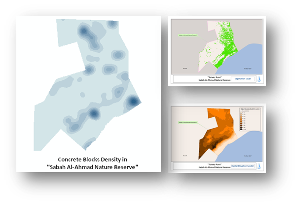
Supergeo Technologies, a leading global provider of GIS software and solutions, supports Public Authority for Agriculture and Fish Resources (PAAF), Kuwait to build a GIS platform, helping with the remediation actions in the military fortifications in Kuwait.
For a desert country like Kuwait, developing agriculture is a difficult job, especially the area surrounded by military constructions. Sabah Al-Ahmad Nature Reserve is one of the affected sites by the remains of more than 240,000 military fortifications at the north of Kuwait Bay. For remediating the damaged area, PAAF cooperates with International Integrated Environmental Services Ltd (IIES), Supergeo Platinum Reseller in Kuwait, to collect field data and set up the enterprise GIS database for military fortifications, concrete blocks and other components.
The main establishments of the project are to utilize survey methodologies, high resolution satellite images and GIS-based software packages to accomplish the objectives. The needed field data is captured through SuperPad, the professional GIS application, and synchronized to SuperGIS Desktop to process, analyze and produce various kinds of map to meet different demands. And then, the project manager can publish satellite images and the GIS layers via SuperGIS Server on the website.
With SuperGIS total solutions, all current and historical attributes for field operations such as vegetation cover, military fortifications, drainage system, Surface sediments, etc., can be perfectly managed and edited by different focused software applications.
For example, through SuperGIS Biodiversity Analyst, users can produce Biodiversity Geo-Atlas to manage images and information of plants, animals, species, and vegetations for determining the usage of a zone wisely.
This project successfully integrated and analyzed huge data to overcome the nature limits and artificial damages in Kuwait. Its outstanding performance also won SuperGIS Application Excellence Award. The Awardee, Public Authority for Agriculture and Fish Resource, Kuwait will receive the Award during the Conference of Discover GIS in Salwa Hall, Kuwait by Supergeo.
# # #
About Supergeo
Supergeo Technologies Inc. is a leading global provider of GIS software and solutions. Since the establishment, Supergeo has been dedicated to providing state-of-the-art geospatial technologies and comprehensive services for customers around the world. It is our vision to help users utilize geospatial technologies to create a better world.
Supergeo software and applications have been spread over the world to be the backbone of the world’s mapping and spatial analysis. Supergeo is the professional GIS vendor, providing GIS-related users with complete GIS solutions for desktop, mobile, server, and Internet platforms.
Read More »Supergeo Establish User Network with Evolving Geosystems in UAE
Supergeo Technologies, a leading global provider of GIS software and solutions, announces the official reseller agreement with Evolving Geosystems Technologies (EGT) to keep providing high-quality total SuperGIS solutions in UAE.
Located in Dubai, EGT provides sophisticated GIS solutions, analysis, turnkey systems, custom applications, and technical support for government sectors, higher educational institutes, and the enterprises focusing on oil and gas, utilities, defense, etc. The professional team at EGT can assist different groups in making better decisions with the abundant functions in SuperGIS.
Focusing on state of the art GIS technologies, Supergeo provides total GIS solutions which includes desktop, mobile, server and engine for general users and GIS developers. No matter project managers, GIS analysts, field surveyors or even non-GIS domain users, SuperGIS software’s user-friendly interface and powerful functionality are to maximize efficiency and minimize the costs.
SuperGIS comprehensive solutions have been used worldwide to meet the challenges and requests in diverse domains. The further collaboration with Middle Eastern enterprise, Evolving Geosystems Technologies, also encourages Supergeo to support advanced GIS for organizations and professionals in UAE.

# # #
About Supergeo
Supergeo Technologies Inc. is a leading global provider of GIS software and solutions. Since the establishment, Supergeo has been dedicated to providing state-of-the-art geospatial technologies and comprehensive services for customers around the world. It is our vision to help users utilize geospatial technologies to create a better world.
Supergeo software and applications have been spread over the world to be the backbone of the world’s mapping and spatial analysis. Supergeo is the professional GIS vendor, providing GIS-related users with complete GIS solutions for desktop, mobile, server, and Internet platforms.
Read More »SuperGIS Desktop 3.1a Supports Civil Engineering and Development for Macerata, Italy
Supergeo Technologies, a leading global provider of complete GIS software and solutions, announced that Macerata City, Italy employed SuperGIS Desktop 3.1a, the latest desktop GIS software to edit, integrate, and manage geospatial information for providing the administrators with reliable information for making crucial policies of civil engineering projects.
Located in the province of Macerata, Macerata is famous for its rich cultural heritages and the Sferisterio Opera Festival. GIS helps the local government establish a GIS platform for better data fusion and management in order to effectively promote the local tourism through feasible planning and consequently build Macerata as one of the most sustainable cities in Italy.
With advanced data processing functions and powerful GIS tools, SuperGIS Desktop 3.1a allows the officials to effortlessly process, query, and analyze spatial data about land use, population distribution, natural resources etc. to improve its service quality and operational efficiency.
Serving as Supergeo’s important business partner in Italy, Helix S.r.l. has successfully assisted the local government sectors and enterprises in overcoming geospatial-related issues using SuperGIS software. By working in a closer cooperation with Helix S.r.l., Supergeo expects to enter into the new markets in Southern Europe through undertaking various marketing activities.
# # #
About Supergeo
Supergeo Technologies Inc. is a leading global provider of GIS software and solutions. Since the establishment, Supergeo has dedicated to providing state-of-the-art geospatial technologies and comprehensive services for customers around the world. It is our vision to help users utilize geospatial technologies to create a better world.
Supergeo software and applications have been spread over the world to be the backbone of the world’s mapping and spatial analysis. Supergeo is the professional GIS vendor, providing GIS-related users with complete GIS solutions for desktop, mobile, server, and Internet platforms.
Read More »QGIS 2.0 Released
This is major news. The popular open source desktop GIS formerly known as Quantum GIS, now simply QGIS, has released its version 2.0 at FOSS4G. This release reduces the gap with some of the mature commercial desktop GIS available. There's also QGIS 2.0 for Android in the works.
Here's the full list of what's new and changed - it's just too long to copy it all, so here's some of it:
User interface:
- Feature: Side tabs, collapsable groups
- Feature: Soft notifications
- Feature: Drag and drop form builder
Data providers:
- Feature: Oracle Spatial support
- Feature: Web Coverage Service (WCS) provider added
- Feature: Raster 2% cumulative cut by default
- Feature: WMTS Support
Symbology:
- Feature: Data defined properties
- Feature: Support for transparency in colour definitions
- Feature: Color Control for Raster Layers
Map composer:
- Feature: Multipage support
- Feature: Layer blending
- Feature: Multicolumn composer legend
Labeling:
-
Feature: Expression based label properties
There's a lot more to it. Head to the full list to learn more and see numerous screenshots.
Supergeo Renews Partnership Agreement with Information & Science Techno System Co. in Japan
Supergeo, the leading global provider of complete GIS software and solutions, renews the partnership agreement with Information & Science Techno System Co., to collaborate on promoting the comprehensive and innovative SuperGIS solutions in Japan.
Founded in 1982, Information & Science Techno-System Co., Ltd. (ISTS) consists of Information System Techno-Center and Space Science Techno-Center which provides clients with image processing, remote sensing service, custom GIS solutions, and the consulting services to satisfy their different application requirements.
SuperGIS software offers a wide range of products and services from Mobile GIS, Desktop GIS, Web GIS, Server GIS to Developer GIS. The flexible development structure allows ISTS to create custom and application-driven approaches for geospatial visualization, data fusion and distribution, geoanalytics, and clever data use.
After reaching the new business agreement this month, the two parties start devising a scheme to further promote SuperGIS software to local government sectors, higher educational institutes, and large enterprises through various marketing campaigns. Supergeo and ISTS will constantly offer technical support to encourage the use of GIS technologies, helping clients explore spatial issues which affect their life or business operations in Japan.
Read More »Public Works and Agriculture Dept., Fujairah Improves Sustainability of Infrastructure with SuperGIS Solutions
Supergeo Technologies announced that SuperGIS solutions including mobile GIS, desktop GIS, and server GIS were adopted by Fujairah Public Works and Agriculture Department, to establish a public works information system to enhance data accuracy, integration, and distribution for sustainable infrastructure programs in UAE.
Public works is the fundamental and first step towards a country's economic development. Fujairah Public Works and Agriculture department plans to extend the life and durability of the infrastructures using GIS technologies and further achieve a balance with regard to environmental protection and economic goals.
In this procurement, SuperGIS Desktop 3.1 helps the department develop a public works information system to visualize and manage spatial data for improved asset and work order management, planning, workflow, as well as greater organizational efficiency. In addition, SuperGIS Server 3.1 allows the department to deliver GIS capabilities and map services throughout the organization to increase the productivity when making crucial decisions.
Supergeo co-exhibited with Evolving GeoSystems at Middle East Geospatial Forum in March to widely promote SuperGIS software in the Middle East region. The two parties will continually encourage the use of GIS through product training to overcome spatial-related problems for users and gradually increase the regional market share.
# # #
About Supergeo
Supergeo Technologies Inc. is a leading global provider of GIS software and solutions. Since the establishment, Supergeo has dedicated to providing state-of-the-art geospatial technologies and comprehensive services for customers around the world. It is our vision to help users utilize geospatial technologies to create a better world.
Supergeo software and applications have been spread over the world to be the backbone of the world’s mapping and spatial analysis. Supergeo is the professional GIS vendor, providing GIS-related users with complete GIS solutions for desktop, mobile, server, and Internet platforms.
Read More »