Tag Archives: desktop GIS

Supergeo Extends Partnership with Geoconnect to Promote SuperGIS in Oceania

SupergeoA, the leading global provider of complete GIS software and solutions, renews the business contract with Geoconnect, to collaboratively promote SuperGIS software and services in Australia and New Zealand. This new partnership agreement will encourage a closer cooperation between the two parties, and therefore make SuperGIS GIS solutions more accessible to local users with spatial application needs.     


Headquartered in Victoria, Australia, Geoconnect is the leading GIS software and hardware supplier who offers GPS, GNNS, rugged computers, and GIS software to help surveyors precisely carry out surveying and efficiently collect field data. Moreover, the company also provides equipment planning and asset management services for industries.


The main clientele of Geoconnect is from utilities, mining, natural sciences and environment, public safety, etc. “Featuring the easy-to-use user interface, powerful GIS functions, and reasonable pricing, the SuperGIS mobile and desktop GIS solutions could help local governments and enterprises greatly save the operational cost and increase the productivity”, the company announced after a comprehensive software evaluation. Geoconnect is confident of the future sales in the local GIS market.


As the global geospatial industry grows steadily year by year, Geoconnect plans to conduct more promotional campaigns which aim to market the latest SuperGIS innovations and successful GIS applications to the target users via its distribution channels. By working in collaboration with Geoconnect, Supergeo hopes to achieve new market penetration in the Oceanian market.


#  #  #


About Supergeo

Supergeo Technologies Inc. is a leading global provider of GIS software and solutions. Since the establishment, Supergeo has dedicated to providing state-of-the-art geospatial technologies and comprehensive services for customers around the world. It is our vision to help users utilize geospatial technologies to create a better world.


Supergeo software and applications have been spread over the world to be the backbone of the world’s mapping and spatial analysis. Supergeo is the professional GIS vendor, providing GIS-related users with complete GIS solutions for desktop, mobile, server, and Internet platforms.

Read More »
gvSIG 2.0 Novelties

During the last weeks several posts about the gvSIG Desktop novelties have been published at the gvSIG Blog. With them we try to make known all these novelties with more details. Until now, the posts that have been publisher are:

  • Scripting, exploit your gvSIG (III): Generate a polygon from a course
  • Symbols library “OSM”
  • “Google” symbols library
  • Scripting, exploit your gvSIG (II). Creating a buffer
  • Mirrors for downloads
  • Add-ons manager
  • How to create symbol libraries (II)
  • Raster data tile cache and WMTS
  • gvSIG 2.0 on 64 bits or Java 1.7 systems
  • Additional feature for managing CRS
  • gvSIG 2.0: Scripting, exploit your gvSIG
  • How to create symbol libraries (I)

In the last weeks new posts will be published, as well as the translation of the last ones in Spanish. Some of them will be related to the new add-ons that will be available for this version. They will be able to be installed from the Add-ons Manager.

Read More »

SuperGIS Application Excellence Award Kicks off

As SuperGIS software has been spread around the world as the major mapping solutions to GIS applications, it is a great opportunity to recognize the partner’s and the clients’ efforts and contributions to GIS implementations. Supergeo is inviting its authorized resellers to share their most outstanding GIS solution to win the contest.


The purpose of this contest is to encourage and reward such remarkable efforts in each respective domain. The annual award, SuperGIS Application Excellence Award of Year, is given to the company who demonstrates practical and innovative solutions/services with SuperGIS software from Web, mobile to desktop applications.


Moalajah, a supplier of water treatment equipment and services in Ajman, was rewarded for its outstanding implementation of “Moalajah e-Map Application” in that was co-developed by Evolving GeoSystems, one of the Supergeo’s outstanding reseller in the Gulf Region.


The winning project used SuperGIS Server 3.1 to distribute geodata services for improved productivity and decision-making. Also, SuperGIS Desktop 3.1 enabled the company to visualize, manage, and analyze spatial data of local properties and network assets to manage wastewater and conserver scarce water resources.


The submitted application showcases shall use SuperGIS software and be nominated by Supergeo authorized resellers. The implementations will be judged on how excellent the GIS project benefits the clients and respective industries. The contest starts from April and ends on August 31. The winner will be invited and awarded on a global GIS exhibition in.

#  #  #


About Supergeo

Supergeo Technologies Inc. is a leading global provider of GIS software and solutions. Since the establishment, Supergeo has dedicated to providing state-of-the-art geospatial technologies and comprehensive services for customers around the world. It is our vision to help users utilize geospatial technologies to create a better world.


Supergeo software and applications have been spread over the world to be the backbone of the world’s mapping and spatial analysis. Supergeo is the professional GIS vendor, providing GIS-related users with complete GIS solutions for desktop, mobile, server, and Internet platforms.

Read More »

New final version of gvSIG available: gvSIG 2.0

The gvSIG Association announces the publishing of the gvSIG 2.0 final version [1]. The main novelty of this version is its new architecture. The way gvSIG manage the data sources has been redesigned with the objective of improving the reliability as well as the modularity, benefiting the users as well as the developers. Besides it permits an easier maintenance and evolution of the technology. Therefore it has been an investment in the future with the aim of not limiting the technological evolution and establish the bases for a quick evolution.

However this new gvSIG Desktop version includes a series of new features:

  • New installer that supports typical and custom installation.
  • Add-ons manager that allows to install new extensions and customize gvSIG from the same application.
  • Some changes in the interface of data management tools like:
    • File import/export
    • Table operations
    • New layer
  • Layer load improved
  • WMTS (Web Map Tiled Service) support
  • Raster data cache
  • Unified geoprocessing interface
  • Import symbols, making the creation of symbols libraries easy.
  • Export symbols, that allows to share complete symbols libraries with other users easily.
  • Scripting framework (languages: Jython, Groovy and Javascript).

Nevertheless it's the last version of gvSIG, it has to be taken into account that it's really a new gvSIG, so you will find that some of the gvSIG 1.12 functionalities are not included. These functionalities will be included in following and continuous updates according to their migration to the new architecture. The main functionalities that are not included are the following:

  • Georeferencing
  • Legend by proportional symbols, graduated ones, dot density, quantities by categories and by expressions.
  • Extensions: Network analysis and 3D

In the same way, there are several projects based on this new architecture that will allow to include new functionalities and improvements directly in gvSIG 2.0 in the next months.

Also it has to be taken into account that the level of stability of this new version is not as high as we would have wished, considering it a final version in order to be used by the community in an official way, and mainly to tackle the new developments on it.

For that, we encourage you to test it and send us any errors in order to fix them in the following updates. The known errors of this version can be consulted in [2].

From this version, several mirrors are now available to download the packages from gvSIG. These mirrors will be available within a few days.  

We hope you enjoy the new features of this version and you help us to improve it.


Read More »

Supergeo releases SuperGIS Server 3.1a

Supergeo Technologies, the leading global provider of complete GIS software and solutions, releases SuperGIS Server 3.1a Value Edition and Standard Edition globally.


Designed to create, manage, integrate and publish various types of GIS services, SuperGIS Server 3.1a integrates all types of spatial data, images, and GIS functions with desktop, mobile, and web applications over the Internet, assisting enterprises in building ideal workflow and improving productivity in making decisions.


The newest SuperGIS Server 3.1a features geoprocessing service publishing functions and enhances the efficiency of map cache tools. Not only performing all the functionality offered by value edition, the Standard Edition additionally provides developers with Mobile SDK to customize mobile applications which can access SuperGIS Server services and meet enterprise requirements.


SuperGIS Server 3.1a Standard edition supports to work with diverse analysts, allowing enterprises to publish more comprehensive analysis functions to reduce cost of data duplication and storage.


In addition, a variety of sample descriptions and sample codes of diverse themes are available on SGDN website to help developers customize map webs easily. Therefore, developers can effortlessly create their own mapping applications and increase GIS capabilities to existing applications.

Read More »

uDig 1.4 Released

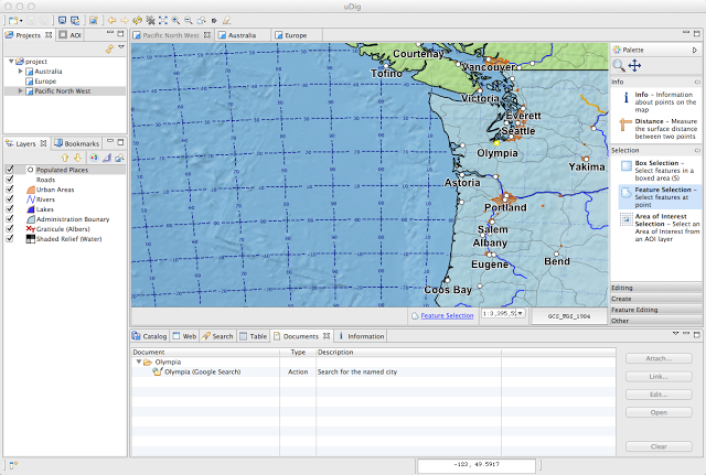
The open source java desktop GIS uDig released its version 1.4. uDig also officially joined LocationTech recently (here's our previous entry on LocationTech).

What's in the 1.4 release: "

For users:

  • GeoScript editor allowing scripting directly from the uDig application
  • Document view for working with attachments and hot-links
  • New graticule map decorator supporting metric coordinate reference systems
  • WMS 1.3.0 now enabled by default

For developers:

  • Provided under a dual EPL and BSD license with associated refresh of a all headers, plugin license and about.html files.
  • Transition to Maven command line build is complete with both product and SDK builds
  • SDK is a complete target platform (no longer requires an Eclipse Download).
  • Based on GeoTools 9.0-M0

Release notes:

  • uDig 1.4.0 Release Notes"

Read More »

Slashgeo is Now a Proud Partner of the 8th International gvSIG Conference

I'm glad to announce that Slashgeo is a proud media partner of the 8th International gvSIG Conference, to be held November 28-30, in Valencia, Spain. We of course frequently mention the open source gvSIG desktop GIS software. gvSIG has its Wikipedia page. One of its strengths is certainly its very active developers community.

From the objective of the 8th International gvSIG conference, with its headline 'Making the Future: Technology, Solidarity and Business': "We have long been hearing and even worse, suffering the consequences of those who really know and are surely making fun of us especially if we tell them that we believe that solidarity should be a core value that guides both scientific and economical development.

Those who have been following us for some time know that in gvSIG we have always been talking about a new model of development and production that would allow us to produce more, better and more fairly; a model where solidarity would substitute rivalry. To construct this new model there has to be new ideas, new schemes, otherwise, if a new model is built based on old schemes this would then lead to utmost failure.

Now more than ever, it is time to consider this new model. Not only by using free software but also by adopting values ​​of collaboration and shared knowledge, replacing individualism with solidarity; this is what guides the development of science and economy, so that the business world follows ethics and responds to different values ​​other than the current ones."

Read More »

Maptitude Product Overview

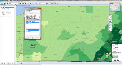
Directions Mag offers a product overview of Maptitude by Caliper Corp., a product we never mentioned before.

From the article: "The U.S. version of Maptitude includes the October geographic data release from NAVTEQ. [...] The census geographic boundary files with Maptitude encompass variables from the Census and the American Community Survey to map demographic information from the state level down to the census tracts. [...]

Maptitude is designed to provide a user with the ability to quickly generate presentation quality maps at a very affordable price and includes a vast database with the product. As an experienced GIS software user, I was able to get up and running with the software very quickly and found the user interface to be very user-friendly and intuitive. Caliper’s website provides free video tutorials for prospective and existing customers to view and learn about the capabilities of the software. I like that Maptitude provides the ability to create maps with the Quick Start and Map Librarian menu. The layers are added and symbolized automatically, which saves plenty of time for a user to create presentation quality maps quickly. I was also impressed with the model estimation tool."


Read More »

Quantum GIS (QGIS) 1.8.0 Released

A lot of geoblogs mentioned the release of Quantum GiS 1.8.0. QGIS is one of the most mature and widely used open source desktop GIS software, with tons of useful community-contributed plugins. Version 1.8.0 is clearly a major update of this already excellent GIS software.

The list of new features is quite long, here's a few of them:

  • QGIS Browser: a stand alone app and a new panel in QGIS. The browser lets you easily navigate your file system and connection based (PostGIS, WFS etc.) datasets, preview them and drag and drop items into the canvas.
  • DB Manager: the DB manager is now officially part of QGIS core. You can drag layers from the QGIS Browser into DB Manager and it will import your layer into your spatial database.
  • New symbol layer types: Line Pattern Fill, Point Pattern Fill.
  • Terrain Analysis Plugin: a new core plugin was added for doing terrain analysis - and it can make really good looking colored relief maps.
  • Ellipse renderer: a new symbol layer type to render ellipse shapes (and also rectangles, triangles, crosses) by specifying width and height.
  • Support for nesting projects within other projects: embed content from other project files.
  • Layer grouping: Option to add layers to selected or active group.
  • Customization: Allows setting up simplified QGIS interface by hiding various components of main window and widgets in dialogs.
  • Action Tool: accessible from the map tools toolbar. It allows you to click on a vector feature and execute an action.
  • Pan To Selected tool: Pans the map to selected feature(s); does not change the zoom level.
  • Updated CRS selector dialog
  • Legend-independent drawing order: The order seen in the legend can be different from the display order.
  • Other features include: MSSQL Spatial Support, Expression based labelling, Heatmap tool, WFS support in QGIS Server, and much more

Head to the release notes (link above) to learn more and see screenshots.

Read More »

ThinkGeo Releases Map Suite 5.5 with Robust Printing, Contour Lines and Stability Improvements

Frisco, TX – ThinkGeo has released version 5.5 of Map Suite, its full line of GIS software components for .NET developers.  This major milestone refresh introduces two important new features: a robust map printing and page layout system, and support for generating visually stunning contour lines (also known as isolines).  A wide variety of bug fixes and stability improvements round out the 5.5 release of Map Suite.

With Map Suite’s new printing system, .NET software developers can use the Map Suite GIS controls and components to add robust map printing capabilities to their GIS applications.  Map Suite 5.5’s new PrinterLayer can programmatically prepare and print attractive page layouts containing not only high-resolution maps, but also images, labels and titles, scale bars and lines, north arrows and data grids.  In addition, Map Suite Desktop and WPF Desktop Editions have the added bonus of the PrinterInteractiveOverlay, which allows the end user to assemble their own custom page layout using a graphical user interface.  Either way, the end product can either be printed, exported to a PDF document or a raster image file.

Contour lines (also known as isolines) are also new to Map Suite 5.5 and offer a compelling way to visualize breaks between different groups of data – such as elevation levels, soil properties and much more.  All editions of Map Suite now have the ability to generate contour line maps either dynamically or via a set of input data.

Both the new printing and contour line features are supplemented with sample code available on the ThinkGeo Wiki and 30-minute instructional videos narrated by David Rehagen, Map Suite’s Chief Architect.

Other noteworthy enhancements in the Map Suite 5.5 release include a high-performance rewrite of the Bing™ Maps overlay (which also now includes support for Bing Maps Enterprise Keys), the ability to download tiles from a WMS layer simultaneously instead of serially in Map Suite Web Edition, an update to the latest address data in Map Suite Geocoder, and an overhauled routing API for improved performance in the Map Suite Routing Extension.  Beyond that, a variety of bug fixes and stability improvements have been added throughout the Map Suite GIS product range.  Complete change logs are available at the ThinkGeo Wiki, the company’s official online source for Map Suite documentation, reference and learning material.  The 5.5 update includes new builds of all of Map Suite’s major editions, including Desktop, Web, Silverlight, WPF Desktop, Services and WMS Server Editions, as well as the Map Suite Geocoder, World Map Kit and other Map Suite extensions.

ThinkGeo has also announced plans to release special “daily builds” of each Map Suite product in the coming weeks, which will introduce several new features that did not make it into the final Map Suite 5.5 release.  Developers will be able to test these new capabilities, which include memory usage and drawing speed improvements, support for the latest versions of MrSid and ECW files, and XML serialization for storing layers, styles and much more across different Map Suite versions.

ThinkGeo’s biannual release plan puts them on track to unveil the next major milestone of Map Suite, version 6.0, in May.  GIS professionals who wish to request specific features or enhancements for the next revision of Map Suite are encouraged to visit ThinkGeo’s Enhancement Tracker, where they can vote on their favorite enhancement ideas and suggest new ones directly to Map Suite’s development team.

For more information about Map Suite, or to download a free 60-day evaluation of any Map Suite 5.5 product, visit ThinkGeo’s website.  New users and existing users alike can discuss and get help with their Map Suite applications at ThinkGeo’s official Discussion Forums.

ThinkGeo is an industry leader in GIS mapping components and customizable GPS tracking solutions.  The company offers a wide variety of high-quality geospatial products for software development, asset tracking and much more.  They have clients from a wide base of industries ranging from agriculture to aerospace.

Read More »