Tag Archives: open data

Open Source / Data Geonews: MapGuide 2.2, GeoRepository and GeoServer-Manager, OpenStreetMap News, and more

Here's the recent geospatial open source / data news for the last 8 days or so. On geospatial open source:

  • The Autodesk-supported web mapping software MapGuide Open Source 2.2 was released
  • Here's a preview of GeoRepository, and advanced authorization manager for GeoServer and the new GeoServer-Manager, a simple Java client library for GeoServer
  • OpenGeo introduced the OpenGeo Gallery, to answer the question 'who uses the open source software that OpenGeo supports'
  • There's the first release of Image Georeferencing View for uDig 1.2.1
  • GeoTools has a new User Guide and so does Sextante GIS
  • Shapely 1.2.10 has been released
On open geospatial data, mostly OpenStreetMap:
  • We mentioned the book last September, and now Geoweb Guru offers a review of the book 'OpenStreetMap: Using and Enhancing the Free Map of the World'. From the review: "Due to the overview nature of a wide range of different applications and projects, it is likely that quite a bit of the book will become out of date quite quickly. It is also likely that the data model will evolve."
  • Here's an entry on directions (and correcting erroneous routing behavior) with OpenStreetMap
  • Spatial Sustain shares a perspective asking Is Open Location the Next Open?
  • Here's a screenshot of JOSM on a tablet
Read More »

Third Open Source GIS Conference

Third Open Source GIS Conference - OSGIS Centre for Geospatial Science, University of Nottingham 21-22nd June Building up Open Source, Open Standards, Open Data research The Provisional agenda for the Third Open Source GIS Conference is now available The OSGIS conference series has a strong international focus and takes a holistic approach in bringing together speakers and delegates from government, academe, industry and open source communities. High profile speakers from all over the world are invited for giving presentations and running hands-on workshops for the conference series. The key aims of OSGIS conference series are: 1. to hear presentations from government, academic, industry and policy makers on open source, open standards and open data geospatial technologies 2. to provide platform to network and develop ideas for future collaborative work in open source GIS 3. to understand current developments in open source GIS 4. to act as a focus for open source, open standards, open data GIS research #  OSGIS Keynote presentation: Professor Thierry Badard (Laval University, Canada) #  "Open Nottingham- Knowledge without borders" presentation -Prof. Christine Ennew (Pro Vice Chancellor, University of Nottingham) & Prof. Wyn Morgan (University of Nottingham) #  "The impact of open data, open source software and open standards on the evolution of National SDI's" - Prof. Mike Jackson (Director, Centre for Geospatial Science) OGC-OSGeo Interoperability Day on 21 June (Organised by Tyler Mitchell, Executive Director, Open Source Geospatial Foundation) Workshops for Interoperability Day # Mapserver Workshop - (Astun Technology, UK) # One Geology Workshop - (British Geological Survey) # Geoserver Workshop - (GeoSolutions, Italy) # WMS/QGIS Workshop - (Faunalia,UK) Open Data Revolution Workshop on 21 June - (Horizon Institute, University of Nottingham and Creative Commons) gvSIG Day (Organised by gvSIG Association, Spain) will be held on 22 June Early bird registration closes on 6 May.   We look forward to welcoming you for joining us in our vision and mission on further building up Open Source, Open Standards, Open data theme.

Read More »

openBmap: Open Map of Wireless Communicating Objects

Via Kurt, I learned about openBmap, a free and open map of wireless communicating objects. From the website: "openBmap is a free and open map of wireless communicating objects (e.g. cellular antenna, Wi-Fi, Bluetooth). It provides tools to mutualize data, create and access this map. Help us build a free database! Open source logging applications are available for Android2 phones, WindowsPhone6 and the openmoko freerunner freesmartphone phones." The database currently contains for cellular objects: "169 countries, 578 mobile networks, 34,961 location area codes, 706,606 cells (which 218,727 are trusted)"

Read More »

FOSS4G Geonews: Major OpenStreetMap 3D Update, ESRI Open Sourcing the File Geodatabase API?, and much more

Despite being on April Fool's day, this is real recent geospatial open source / open data news. We mentioned a few times efforts related to OpenStreetMap in 3D, now the OpenGeoData blog shares news about the new major version of OSM.globe and OSM-3D: "The "osm.globe" combines the free geodata from OpenStreetMap with digital elevation models offering a global interactive 3D experience made completely from free or crowdsourced geodata. [...] It is now also possible to drape different OSM maps or satellite imagery onto the elevation model. Further the 3D globe now can be integrated into a web-site as Java applet (featuring a JavaScript API), as well as Java Webstart application or users can download and install it as Java Desktop application." If you're like me, you'll want to take a look at the OSM-3D screenshots and maybe the videos too. In other news:

  • APB mentions the possibility that ESRI open sources the File Geodatabase API
  • Here's an entry on converting a GeoTIFF color palette to the Symbology Encoding standard
  • Here's an entry on OpenStreetMap and transportation
  • The City of Montreal is getting ready to open its data [in French], including geospatial datasets
  • The FGT blog discusses the geo-related services in the open source Data Science Toolkit
  • Here's a FAQ on the integration of MapGuide Open Source and Google Maps and part 2 of the Maestro 3.0 walkthrough
  • Via mapperz, if you're looking for some April Fool's fun, take a look at OpenWhateverMap
  Read More »

Governement of Canada Launches Open Data Pilot which Includes Geospatial Datasets

 Via internal mail I learned about the launch of the Government of Canada's Open Data pilot project. There's also a link allowing you to directly browse their 'geospatial collection', which, if I'm still able to add numbers, offers a total of 166 geospatial datasets (unless some datasets are found in multiple categories?). The main page claims that there is 260,296 geospatial datasets already available. No matter what the actual numbers are, it's still a great day for open data in Canada. From the data.gc.ca backgrounder page: "The GC Open Data Portal is a collaborative effort amongst Government of Canada departments and agencies to provide access to data managed by the government that can be leveraged by citizens, businesses, and communities for their own purposes. The government will work towards making public data that is not sensitive in nature (i.e. data which is NOT personal, secret, or confidential) broadly available in reusable formats."

Read More »

FIND launches a new free mapping website

  FIND, the mapping technology company, announces the launch – a unique website that makes it possible for members of the public to create and customise their own maps for free. 
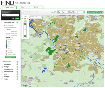
Last year the UK government released numerousdatasets to the public, an example being the Ordnance Survey’s OS OpenData. However, to date the public has not had access to this data in a useful and accessible manner. FIND’s Personalise Your Map website is an exciting development that allows the members of the public to make use of UK government data for their own needs. The site gives unprecedented access to a range of constantly updated maps and information from respected UK government sources such as Natural England, Ordnance Survey and Historic Scotland. For the first time users have been provided with a powerful mapping toolset meaning that rather than simply viewing a map users can now customise their own. Maps can be annotated with shapes, text, symbols, styling, and usefulmeasuring tools then saved to PDF in a neat print template. The result is customised cartography at no cost. An exclusive feature of the portal is the ability to customise a Google Map through the ‘Your Google Map’ feature. Users have the ability to change the colour of every feature on a Google map globally to suit their specific requirements and preferences. Mariam Crichton, CEO of FIND says “ offers individuals the ability to mark up their own maps and share these with a wider audience. The possibilities of its use are endless, from customising a wedding invitation to sharing the details and the location of a significant local event for example the impact of major weather incident. The website acts as a powerful tool for communicating mapping information on a global scale”.

Read More »

‘ShareGeo Open’: U.K. Open Geospatial Data Repository Launched

The FGT blog informs us of the recent launch of 'ShareGeo Open', an open geospatial data repository in the U.K. While the initiative is U.K.-focused, FGT seems to indicate that it's open for use by anyone. From their about: "ShareGeo Open is a spatial data repository that promotes data sharing between creators and users of spatial data. It is the place where researchers, students and lecturers at UK HEFE institutions can deposit data for anyone to download and use. This will both increase the use of spatial data and forge links between data creators and data consumers. Data held in ShareGeo Open can also be discovered through aggregating search portals such as Go-Geo!. ShareGeo Open was developed as part of EDINA's continuing goal toensure continuity of access to data for the UK academic and education sector."

Read More »

New OpenDEM Initiative

Via the OSM blog, I learned about the new OpenDEM.info project. From the site: "There are many ways to record the earth´s surface:

  1. Aerial photography
  2. Remote sensing
  3. Microdrones
  4. GPS
  5. Trachymeter
If you have any height data that could be licensed under the Open Database License or current OSM license (CC-BY-SA), please provide the dataset, so it can be used by the project." So far, they seem to offer very little datasets, but don't all projects have to start somewhere? I guess they should include, if they can license-wise, the CGIAR-CSI SRTM-DEM Version 4 and ASTER GDEM amongst already free and available DEMs. There are plenty of already free DEM datasets that probably can't be added to OpenDEM due to licensing issues, such as Canada's CDED. Read More »

An e-Learning Framework for using Geospatial Open Data, Open Source and Open Standards

The Centre for Geospatial Science in partnership with Mimas (University of Manchester) is starting a new JISC-funded project called ELO-Geo (An e-Learning Framework for using Geospatial Open Data, Open Source and Open Standards). The objective of this project is to enable the wider community (not just GIS experts) to make use of open source geospatial tools for solving real world problems. We welcome all interested in this initiative to share their ideas about the possible training materials for open geospatial community to be in contact with the project lead.

Read More »

CryoSat Ice Data Now Open to All

 The ESA published today an article named CryoSat ice data now open to all. From the article: ""As of today, the international science community will have free and easy access to all of the measurements from CryoSat. This will amount to a unique dataset to determine the impact climate change is having on Earth's ice fields."  [...] Launched in April last year, CryoSat and the ground processing set-up have shown to be in excellent working order. [...] CryoSat carries a sophisticated radar altimeter that can measure the thickness of sea ice down to centimetres and detect changes in ice sheets, particularly around the edges where icebergs are calved from the vast ice sheets that cover Greenland and Antarctica."

Read More »