Tag Archives: remote sensing

Batch Geonews: Predictions, Near Real-Time Imagery of Earth, Location Privacy, LiDAR Formats, and much more

The first batch geonews edition!

On the open source / open data front:

  • An informative update on the OGR OpenFileGDB driver to read Esri's file geodatabase format
  • Plugin to display QGIS 2D maps in 3D in a web browser via three.js
  • Interesting predictions and trends, Juan Marin’s Predictions for and Paul Ramsey’s Predictions for and MapBrief Geo Predictions
  • We never mentioned the open source data portal software before, but it supports geospatial data pretty well
  • Via OR, MapGive — U.S. State Dept launches OpenStreetMap contributing tool “to help humanitarian efforts”, and the State of the Map will be held in Buenos Aires
  • Some software updates, MapGuide Maestro 5.1, Geopaparazzi 3.9.0 is out, SAGA 2.1.1 released, Mapbox.js v1.6.0
  • Using open source software to answer Will the sun shine on us?
  • Talking of the sun, News from Marble: Introducing Sun and the Moon and Planets

On the Google front:

  • Really worth taking a look to Climate Viewer 3D: The Google Earth Climate Change, Pollution and Privacy Viewer
  • A new book, Google Maps JavaScript API CookBook
  • Viewing the Topography of the Thermohaline Circulation of the Oceans in Google Earth
  • There's New 3D imagery in Tokyo and other Japanese cities
  • From Slashdot. Google Removes "Search Nearby" Function From Updated Google Maps
  • Why not, Creating artwork based on Street View
  • If genealogy is within your interests, Genealogy through Google Earth

On the Apple front:

  • Description of an Apple Maps App with Interactive Data Layers Detailed in New Patent
  • Will this concept catch up? Apple's iBeacon Technology Brings New Possibilities for Location-Based Gaming
  • Nokia's HERE not popular enough? Nokia Pulls 'HERE' Maps App for iOS, Citing iOS 7 Changes That 'Harm the User Experience'

Discussed over Slashdot:

  • Yes, this is coming, Swarms of Small Satellites Set To Deliver Close To Real-Time Imagery of Earth another related entry is named Planet Labs to capture near-continuous whole-Earth imagery from 28 five kilogram satellites
  • If you're a regular Slashgeo reader, you know this already, Why the World Needs OpenStreetMap, and it's time to migrate 'en masse' according to The Guardian
  • On privacy, It's Not Just the NSA: Police Are Tracking Your Car
  • But you know what? Carmakers Keep Data On Drivers' Locations From Navigation Systems
  • And here's a confirmation, Ford Exec: 'We Know Everyone Who Breaks the Law' Thanks To Our GPS In Your Car
  • But there's always hope? Recent Federal Trade Commission (FTC) Settlement Will Make It Harder to Collect and Share Geoinformation In US
  • First step before commercial drones, Feds Announce Test Sites For Drone Aircraft
  • For fun, CES: Building Self-Guiding Lego Robots for Fun and (Maybe) Profit (Video)
  • There are still wonders to discover, thanks to geo, Lasers Unearth Lost 'Agropolis' of New England
  • Tracking bees, Scientists Glue Sensors To 5,000 Bees In a Bid To Better Understand Them

In the everything else category:

  • A geodesy dream? Affordable Arduino-Compatible Centimeter-Level GPS Accuracy
  • Using LIDAR data? Read Format Wars Episode V: LIDAR, why? Esri Launches its Own Propriety Compressed LiDAR Format: .zlas
  • An article on Spike, creating 3D models of buildings and things with a smartphone, not the first app of that kind but that one comes from a GIS company
  • Free map online course from Coursera to begin in April
  • You already know what IFTTT recipes are? Here's you'll learn about geoenabling triggers with geofences and more
  • Here's about SenseFly, a drone for taking oblique imagery
  • A generic entry on the Cocktail of Technologies for Smart Cities: The role of Geospatial Tech
  • Wired on Tracking the Secret Lives of Great White Sharks
  • Let's talk about our privacy again, DARPA’s 1.8 gigapixel ARGUS-IS: The Ultimate Surveillance System from above?, that's 1.8 gigapixels and 12 frames/second, 24/7
  • On the SPOT remote sensing satellite family, up to SPOT 7, The new SPOTs
  • On 3D printing, yup, really mainstream now, Adobe Adds 3D Printer Support To Photoshop and here's about the open source ' slic3r ' — converts a digital 3D model into printing instructions for your 3D printer (via OR)

In the maps category:

  • On mapmaking, The Hidden Meanings of Maps: Design and Colors
  • Beautiful, A woodcut inspired map for city streets
  • Jonathan provides a book Review: A History of the World in Twelve Maps
  • And here's A look at twelve maps that changed the world
  • Don't we all like beautiful maps? Wired shares The Most Amazing, Beautiful and Viral Maps of Year
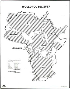
  • Here's a map you have to see, would you believe how big is Africa? Mercator projections are messing with our perception of the world

Read More »

Yann Arthus-Bertrand’s ‘Earth From Space’ Book

For some of us, it's already time to think about Christmas gifts. Here's a new nice 'geo' book released earlier this month, it's Yann Arthus-Bertrand's Earth from Space, which includes 150 breathtaking satellite images. Wired shares 12 satellite images from the book - worth taking a look.

The book description: "From space, Earth is a magnificent sight, splashed with vivid colors, patterns, textures, and abstract forms. Views from above can also provide telling information about the health of our planet. To help us understand the more than 150 breathtaking satellite photographs in Earth from Space, Yann Arthus-Bertrand, an aerial photographer and devoted environmental activist, discusses the impact of deforestation, urban sprawl, intensive farming, ocean pollution, and more. Using high-resolution imagery, we can monitor the evolution of vegetation around the Chernobyl nuclear disaster site, snow loss on Mount Kilimanjaro, and the health of migratory bird populations. Earth from Space’s compelling selection of satellite images raises important questions about our future, while also showcasing the planet’s beauty—leaving no doubt that it is something crucial to protect."


Read More »

Batch Geonews: Google Views and 150 New 3D Cities, Future of National Mapping Agencies, Sentinel Imagery Free, and much more

A batch mode edition while on holidays. Next one will be late August since I'll be away from computers (and even without electricity!) for a few weeks.

From the open source / open data front:

  • With open source software, you can get Super Sharp 50cm Pléiades Satellite Imagery on MapBox, "Any point on Earth, everyday, with 50cm resolution. With this guide you can go from image download to rendered maps in minutes, all with open software."
  • Here's a Digital Trends article named Google Map Maker vs. OpenStreetMap: Which mapping service rules them all?
  • With Foursquare direct OpenStreetMap editing, could encourage others to provide the same direct OSM editing (via Mapperz)
  • Fiona 1.0 released, "Fiona is OGR's neat, nimble, no tears API", a Python library
  • Work continues, OpenLayers 3.0 alpha 4
  • Interesting, Why OpenGeo Has Taken on Outside Investment

From the Esri front:

  • There's New Developer Subscriptions for ArcGIS Online​
  • Esri and open source, New Esri Open Source Javascript Projects: Esri-Leaflet, Geoservices.js, Terraformer, Pushlet
  • Still competing, Esri and MapBox play well together via Arc2Earth
  • More integration with Microsoft too, Esri Maps for SharePoint 3.0 Released!

From the Google front: 

  • Google is Introducing “Views” - A new way to contribute your 360° photo spheres to Google Maps
  • Many will be happy, Google pushing out 3D Imagery at a rapid pace, with about 150 new cities with the 3D imagery
  • Not intuitive, What the imagery dates really mean in Google Earth
  • Tips on Making high-quality movies with Google Earth
  • I have one too and I agree, The SpaceNavigator remains the best way to use Google Earth

A big bunch of geospatial-related news discussed over Slashdot:

  • We mentioned a few times GPS spoofing, Students Hijack $80 Million Superyacht With GPS Spoofing
  • Autonomous, aka driverless cars, are really getting closer, Full-Size Remote Control Cars
  • For 3D printing, Fuel3D Start-Up Promises Affordable Point-and-Shoot 3D Scanner
  • And an 'undo', 3D Printing In Gel Enables Freeform Design and an Undo Function
  • Privacy again, Fifth Circuit Upholds Warrantless Cellphone Location Tracking
  • Privacy in Russia, Moscow Subway To Use Special Devices To Read Data On Passengers' Phones
  • And we told you before that RFID isn't safe, Long Range RFID Hacking Tool To Be Released At Black Hat
  • Drones in the sky? No, that's underwater drones now, DARPA Hydra: An Unmanned Sub Mothership to Deploy Drones
  • Stores too, Retail Stores Plan Elaborate Ways To Track You
  • Crowdsourcing the perception of cities via pictures, MIT's "Hot Or Not" Site For Neighborhoods Could Help Shape Cities
  • If you feel up to, DIY Satellite Tracking
  • To end with a map, A Circular New York City Subway Map To Straighten Things Out

In the everything-else category:

  • Geoff shares a summary of the UN report on The future of national mapping agencies over the next 5-10 years - this is a must read even to those not in the governmental sector
  • More free imagery, from the Sentinel satellite this time, The European Commission Plans Remote Sensing Satellites and Free Access to their Data  
  • Apple is looking to improving power management of mobile devices by remembering charging locations and usage patterns 
  • Interested in contributing to Apple Maps? Apple Filling Out its 'Ground Truth' Mapping Team with New Regional and Local Job Listings
  • For your non-geo colleagues, Get to Know a Projection: Mercator
  • Here's a 4-minutes video, DigitalGlobe takes a look at the last 50 years of the satellite industry
  • An ESA article on watching wetlands from space

In the maps category:

  • Cars, Visualizing New York’s Road Accidents With the Interactive ‘Crashmapper’
Read More »

Celebrating 30 years of GRASS GIS!

Today the Free Software community celebrates the 30th birthday of GRASS GIS! GRASS (Geographic Resources Analysis Support System) is a free and open source Geographic Information System (GIS) software suite used for geospatial data management and analysis, image processing, graphics and map production, spatial modeling, and 3D visualization. GRASS GIS is currently used in academic and commercial settings around the world, as well as by many governmental agencies and environmental consulting companies. GRASS GIS can be used either as a stand-alone application or as backend for other software packages such as QGIS and R geostatistics. It is a founding member of the Open Source Geospatial Foundation (OSGeo) and can be freely downloaded.

30 YEARS OF GRASS GIS!

Brief history

In 1982, Lloyd Van Warren, a University of Illinois engineering student, began development on a new computer program based on a master's thesis by Jim Westervelt that described a GIS package called LAGRID – the Landscape Architecture Gridcell analysis system. Thirty years ago, on 29 July 1983, the user manual for this new system titled "GIS Version 1 Reference Manual" was first published by J. Westervelt and M. O'Shea. The software continued its development at the U.S. Army Corps of Engineers Construction Engineering Research Laboratory (USA/CERL) in Champaign, Illinois; and after further expansion version 1.0 was released in 1985 under the name Geographic Resources Analysis Support System (GRASS). The GRASS GIS community was established the same year with the first annual user meeting and the launch of GRASSnet, one of the internet's early mailing lists. The user community expanded to a larger audience in 1991 with the "Grasshopper" mailing list and the introduction of the World Wide Web. The users' and programmers' mailing lists archives for these early years are still available online.
In the mid 1990s the development transferred from USA/CERL to The Open GRASS Consortium (a group who would later generalize to become today's Open Geospatial Consortium -- the OGC). The project coordination eventually shifted to the actual international development team made up of governmental and academic researchers and university scientists. Reflecting this shift to a project run by the users, for the users, in 1999 GRASS GIS was released the first time under the terms of the GNU General Public License (GPL).

Since these early days GRASS development has progressed and grown, adjusting with and often at the forefront of new technologies as they became available. Today GRASS's software development is maintained by a team of domain experts as visualized in this beautiful new video animation which stylistically details the codebase evolution and modifications from 1999 through to, up to and including the latest GRASS GIS 6.4.3 stable release.

30 years of active growth: where are we now?

Recent versions of GRASS GIS come with exciting new features like:

  • new modern graphical user interface complete with integrated workflow-wizards and interactive tools,
  • new Python interface to the core C geoprocessing libraries, permitting Python developers to create powerful new modules in a quick and simple way,
  • Fully-fledged topological vector support for editing and tools for topological analysis and data cleaning,
  • Hundreds of new modules to analyze raster and vector data of all scales and types, with hundreds more contributed in an active community repository,
  • Support for massive data processing (e.g. relevant for LiDAR processing) and Large File Support (> 2GB, 64-bit files on 32-bit systems),
  • A codebase portable to all of today's major Operating Systems,
  • Installed on everything from low-power dataloggers and field laptops to high performance Grid Engines and TOP500 supercomputers.

GRASS GIS is currently developed by a global team of around twenty core programmers, plus numerous add-on contributors, testers, and translators. Overall, more than seventy core developers have worked on the code in the past thirty years, making over fifty-thousand modifications to the code. All the while, hundreds more have provided peer review and improvements to algorithms and documentation while using GRASS GIS in professional, educational, and research contexts.

Where to next?

Development on GRASS GIS continues with as much energy and interest as ever. Version 6.4.3 has been released as a birthday present. Parallel to the long-term maintenance of the GRASS 6 stable series, effort is well underway on the new cutting-edge major release, GRASS GIS 7, bringing with it many new features, modules, enhancements, and cleanups. As in the past, the GRASS GIS community is open to any contribution, be it in the form of programming, documentation, testing, financial sponsorship or any other form of support.

--
M. Neteler (GRASS GIS PSC Chair) and GRASS Development Team

Read More »

ARKYD Crowdfunding Satellites and CubeSat

[It's Summertime! I'm on holiday this week and will share more geonews next week]

We mentioned DIY remote sensing imagery before, now it went in a new direction with a successful Kickstarter crowdfunding for the ARKYD telescope. Here's the direct link to the ARKYD Kickstarter project dubbed "a space telescope for everyone" which gathered over 1M$ and there's still 4 days for you to contribute to get your own pictures from space.

The Slashdot summary: "Most of you know about Planetary Resources, the asteroid mining company, and their Kickstarter campaign in the finest spirit of Heinlein's The Man Who Sold the Moon. The campaign has reached its minimum $1M goal to get funded with eight days left to go. In celebration, PR's CEO and Chief Asteroid Miner Chris Lewicki does an interview with Forbes where he discusses the future opportunities, the potential pitfalls, and the unlimited potential of private sector space exploitation. It's well worth the read. Planetary Resources' kickstarter has some worthy stretch goals that are well worth looking at, and the sort of supporter premiums that many Slashdotters will not want to miss. Only $175,000 more and they get a second ground station, at $2M they add exoplanet search capability. Both of these stretch goals are within reach."

Another similar story recently discussed over Slashdot is named CubeSats Spurring Satellite Revolution.

The Slashdot summary: "Thanks to the miniaturization of electronics, small CubeSat satellites have quickly become the standard for orbital Earth monitoring. Their modular design and lower cost makes them accessible to many, from university researchers to backers of crowdfunding campaigns. This year, the number of CubeSats launched will at least double the number in orbit to date."

Read More »

Homebrew Camera Mod Mimics LANDSAT Satellite

Slashdot discusses a story named Homebrew Camera Mod Mimics LANDSAT Satellite.

Their summary: ""These folks at Public Lab have published instructions to hack a conventional camera to do photosynthesis photography, just like NASA's LANDSAT satellite. What better way to introduce your kids to space technologies and learn more about the environment? Measure the health of your garden, all with a simple filter switch and some post-processing.

Read More »

RADARSAT-1 Declared Dead after 17 Years of Service

Canada's RADARSAT-1 satellite had problems in late March and has been declared no longer operational earlier this month by the Canadian Space Agency. Continuity was planned with RADARSAT-2 which started providing imagery in early and RADARSAT-C slated for orbit in.

From the press release: "During its 90,828 orbits around the earth it provided 625,848 images to more than 600 clients and partners in Canada and 60 countries worldwide. It assisted with information gathering during 244 disaster events and literally mapped the world, providing complete coverage of the World's continents, continental shelves and polar icecaps. Among its many accomplishments, RADARSAT-1 conducted Antarctic Mapping Missions (AMM) in 1999 and and delivered the first-ever, unprecedented high-resolution maps of the entire frozen continent. It also delivered the first stereo-radar coverage of the planet's landmass, the first high-resolution interferometric coverage of Canada, and produced complete single season snapshots of all the continents."

Read More »

Landsat 8: A Closer Look at LDCM’s First Scene

VerySpatial informed us of NASA's closer look at LDCM's first scene. LDCM is to be renamed Landsat 8. Slashdot also discusses this story and link to a GizMag article.

From NASA: "Turning on new satellite instruments is like opening new eyes. This week, the Landsat Data Continuity Mission (LDCM) released its first images of Earth, collected at 1:40 p.m. EDT on March 18. [...] LDCM sees eleven bands within the electromagnetic spectrum, the range of wavelengths of light. OLI collects light reflected from Earth's surface in nine of these bands. Wavelengths on the shorter side include the visible blue, green, and red bands. Wavelengths on the longer side include the near infrared and shortwave infrared. LDCM's second instrument, the Thermal Infrared Sensor (TIRS) detects light emitted from the surface in two even longer wavelengths called the thermal infrared. [...] LDCM's normal operations are scheduled to begin in late May when the instruments have been calibrated and the spacecraft has been fully checked out."

Read More »

Landsat 8 Satellite Successfully Launches Into Orbit

I'm currently abroad but wanted to share the good news that Landsat 8 Satellite Successfully Launches Into Orbit.

The Slashdot summary: ""The Landsat Data Continuity Mission is now in orbit, after launching Monday from Vandenberg Air Force Base in Calif. After about three months of testing, the U.S. Geological Survey will take control and the mission, renamed Landsat 8, will extend more than 40 years of global land observations critical to energy and water management, forest monitoring, human and environmental health, urban planning, disaster recovery, and agriculture." We still need more new observation satellites to avoid losing Earth observing capabilities as the work horses of the NASA/USGS fleet die of old age."

Read More »

First City In the US To Pass an Anti-Drone Resolution

Drones are a great way to do cheap remote sensing, but regulations are becoming more severe, Slashdot discusses a story named First City In the US To Pass an Anti-Drone Resolution.

Their summary: "According to an Al-Jazeera report, 'Charlottesville, Virginia is the first city in the United States to pass an anti-drone resolution. The writing of the resolution coincides with a leaked memo outlining the legal case for drone strikes on U.S. citizens [on foreign soil] and a Federal Aviation Administration plan to allow the deployment of some 30,000 domestic drones.' The finalized resolution is fairly weak, but it's a start. There is also some anti-drone legislation in the Oregon state Senate, and it has much bigger teeth. It defines public airspace as anything above your shoelaces, and the wording for 'drone' is broad enough to include RC helicopters and the like."

Read More »