The pycsw team announces the release of pycsw 1.10.0.The 1.10.0 release brings significant features, enhancements and fixes to the codebase, including: support OGC OpenSearch Geo and Time Extensions standard support for Open Archives Initiative Protocol for Metadata Harvesting (OAI-PMH) support spatial dateline queries better support for geospatial links via the Python geolinks library fix CSW harvesting to harvest full records ...
Read More »Tag Archives: software
OpenLayers 3.0 Released
This is major news. The open source OpenLayers library is one of the most widely used web mapping software. After a complete overhaul of the venerable 2.x branch, OpenLayers 3.0 has been released. From the announcement: “This release includes a ton of new features such as an easier to use API as well as improved vector rendering and image manipulation. […] ...
Read More »Avenza Releases MAPublisher 9.5 for Adobe Illustrator
- Cartographic add-on now compatible with Adobe Illustrator Creative Cloud™ - Toronto, ON, July 9 - Avenza Systems Inc., producers of the PDF Maps app for mobile and geospatial plug-ins for Adobe Creative Cloud, including Geographic Imager for Adobe Photoshop®, is pleased to announce the release of MAPublisher 9.5 for Adobe Illustrator. This latest update includes many new features ...
Read More »Open Source Geonews: Leaflet Tips and Tricks, QGIS MOOC, ArcGIS vs Open Source, FOSS4G Program, and more
Here’s the recent open source and open data geonews. On the software front: A new version, OpenGeo Suite 4.1 released Updated QGIS plugin for Semi-Automatic Classification Plugin v.3.0 “Rome” released OL3 is not with us yet, but that doesn’t mean we can’t have Editing in OpenLayers 3 using WFS-T Here’s to create Toner-lite styles for QGIS, similar to the ones ...
Read More »The OpenCage Geocoder Enters Public Beta
If you were at State of the Map EU recently, you might have seen the OpenCage Data team launch a new, open data driven, geocoding API. If you weren’t then you might like to know that the OpenCage Geocoder is now publicly available in beta. Powered by OSM data and a whole lot more and wrapping other open source geocoders, ...
Read More »ogr2gui Version 0.7 Released
Inventis today announced the release of ogr2gui version 0.7, the graphical user interface used to convert and manipulate geospatial data. This release would have been possible without the contribution of David Tran in collaboration with Prof. Stefan Keller of the University of Applied Sciences in Rapperswil, Switzerland and Even Rouault from l’École des Mines de Paris. What’s new in this ...
Read More »Announcing the ArcGIS Pro Beta Program
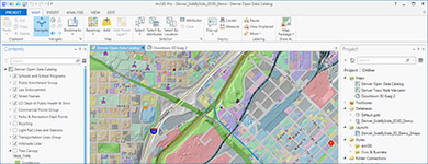
This new software was announced last week. I waited for more information and reactions before sharing it with you, but I haven't found any solid analysis or reviews so far. Esri announced the ArcGIS Pro beta program.
From the announcement: "Esri is pleased to announce the beta release of ArcGIS Pro, which is a new ArcGIS for Desktop application that provides many exciting features. ArcGIS Pro is designed for GIS professionals who need to visualize, edit, and perform analysis—in both 2D and 3D. All current ArcGIS for Desktop customers are invited to download ArcGIS Pro and participate in its beta program. Your work in ArcGIS Pro is organized into projects, which bring together all the resources you need to complete your GIS tasks. You can store as many maps and layouts as you need in the same project, and you can open multiple maps at once and view them side by side. You can package your projects to collaborate with others, or share your work as web maps and web layers. ArcGIS Pro can use local data, as well as content from your ArcGIS Online or Portal for ArcGIS organization. ArcGIS Pro is a 64-bit, multi-threaded application with a modern user experience that runs on the Windows platform."
FOSS4G-Europe – Early Bird Registration extended to May 30
It’s been a busy few weeks as things start to come together for FOSS4G Europe – but now, admittedly with some delay, we have managed the challenge of compiling an exciting program, to be published over the next days.
To give everyone time to have a look at the schedule before booking, we’ve extended the Early Bird registration deadline to May 30. In the meantime, many thanks to all who submitted abstracts – it has been a challenge to select the best of all excellent submissions passed in the last weeks. Altogether, the conference received about 78 abstracts in the general and 16 for the academic track. Every abstract has been carefully evaluated by the program committee to obtain a fair ranking.
On the whole there has been a very satisfying presence of topics relating to the relevant Open-Source- tools like GeoServer, MapServer, Zoo, rasdaman, Grass, and several more. As well OGC-standards like WMS, WMS, WCS, WCPS, WPS, and SOS have the attention of the community. All in all the bandwidth of proposals shows a good representation of the general trends in the geospatial world. In addition the Local Organizing Committee has secured facilities to run additional workshops and a code sprint during the conference.
A lot of registrations form Europe and beyond have poured in already, so make sure you are part of the crowd in this visionary European geo happening. Sign in now!
Read More »FOSS4G Update: Keynotes, Travel Grants, Volunteer Discounts
Two new keynote speakers added to lineup
We are delighted to announce Sarah Novotny of NGINX and Al Shaw of ProPublica as keynote speakers for FOSS4G. They join Mike Bostock of the New York Times in this year's lineup.
Novotny is a technical evangelist and community manager for NGINX, founder of Blue Gecko, and is currently a program chair for O’Reilly Media’s OSCON. Shaw is a news applications developer at ProPublica and the creator of an award winning series of interactive maps documenting FEMA's response to Hurricane Sandy.
Travel Grant Program
To make sure that as many deserving people as possible can attend FOSS4G, we have created a travel grant program with funds to help cover registration, lodging, and travel costs. If you are excited about open source geospatial work but have economic barriers to attendance, we strongly encourage you to apply. Applications are due May 30th, and awardees will be notified mid-June.
Our travel grants are community funded; your donations help bring more of your colleagues to the conference. Consider an additional donation when you register for the conference or as a stand-alone contribution. If every attendee gave just $20, we could bring an additional 20 people to the conference.
Volunteer Discounts
We will also have a limited number of volunteer positions available; in exchange for a full day of work, volunteers will be eligible for a discounted rate of $125. Students will be given preference for these volunteer positions until July 1st. More details on the volunteer program and travel grants.
Important Conference Dates
See the full calendar for more details.
* June 15th: Early bird registration ends
* Sept 8th-9th: Workshops
* Sept 10th-12th: Main Conference
* Sept 13th: Code Sprint
Avenza Releases MAPublisher 9.4 for Adobe Illustrator
- Enhanced cartography tools to create high-quality maps made even easier -
Toronto, ON, May 5 - Avenza Systems Inc., producers of the PDF Maps app for mobile and geospatial plugins for Adobe Creative Suite, including Geographic Imager for Adobe Photoshop, is pleased to announce the release of MAPublisher 9.4 for Adobe Illustrator. This latest update includes new many features including streamlined import, support for additional formats when exporting a document to web tiles, and a new image attribute type to support images imported from the PDF Maps app on both iOS and Android platforms.
"We’re excited to release MAPublisher 9.4 because of its continued evolution to make it even easier to create great looking maps with enhanced cartography tools,” said Ted Florence, President of Avenza. “The enhancements and features in this release have been developed from customer feedback with significant improvements to import and export interoperability. The primary focus of this release is to increase productivity for cartographers and GIS professionals by enabling them to easily and quickly import data, create high-quality map products, and easily publish or export to print and digital formats,” he added.
Enhancements and new features of MAPublisher 9.4
- Streamlined data import: Import (formerly Simple Import) and Multiple Data Import (formerly known as Advanced Import). Improved interface provides additional coordinate system information and easier access to format specific Adobe Illustrator options that affect how data is imported.
- New image attribute type to store an image for each record in a layer's MAP Attribute table. Image attributes are supported when importing from the PDF Maps app (in KMZ format) and exporting to Google Earth (in KMZ format).
- Export Document to Web Tiles now supports MapBox and Tile Map Service map providers. A new anti-aliasing option to optimize art or type is now available.
- New ability to export a coordinate system file for non-geospatial image formats.
- New ability to specify grid constraints to limit the geographical extent of a Measured Grid. In addition, a new option is available for ticks to follow the line at the grid boundary.
- New file export option to assign metadata for TAB/MIF and KML/KMZ formats. The metadata assignment option allows layer attributes to be assigned to format specific metadata fields.
- Improved preview quality makes it easier to see how settings affect the scale bar.
- Newly designed MAP Layer icons and feature type icons.
- Various user interface and performance enhancements to improve usability.
More about MAPublisher for Adobe Illustrator
MAPublisher for Adobe Illustrator is powerful map production software for creating cartographic-quality maps from GIS data. MAPublisher tools leverage the superior graphics design capabilities of Adobe Illustrator to manipulate GIS data and to produce high-quality maps with accuracy and efficiency.
MAPublisher 9.4 for Adobe Illustrator is available free of charge to all MAPublisher users with an active maintenance subscription and as an upgrade for non-maintenance users at US$599. New licenses start at US$1399. MAPublisher FME Auto and MAPublisher LabelPro are also available as add-ons to MAPublisher 9.4 at prices starting at US$399 per license. Academic, floating and volume pricing are also available. Prices include one year of full maintenance.
More about Avenza Systems Inc.
Avenza Systems Inc. is an award-winning, privately held corporation that provides cartographers and GIS professionals with powerful software tools to make better maps. In addition to software offerings for Mac and Windows users, Avenza offers value-added data sets, product training and consulting services, as well as the PDF Maps app for purchasing and using maps on iPhones, iPads and iPod Touch devices.
Read More »