Tag Archives: free

pgRouting 2.0 Released

It's been a crazy week for me and I essentially failed to aggregate geonews - expect me to catch up in the coming days.

The open source routing engine pgRouting version 2.0 has been released, and this a major new release. We mentioned it a few times since.

A reminder of what pgRouting is, from the official website:

pgRouting extends the PostGIS / PostgreSQL geospatial database to provide geospatial routing functionality.

Advantages of the database routing approach are:

  • Data and attributes can be modified by many clients, like Quantum GIS and uDig through JDBC, ODBC, or directly using Pl/pgSQL. The clients can either be PCs or mobile devices.
  • Data changes can be reflected instantaneously through the routing engine. There is no need for precalculation.
  • The “cost” parameter can be dynamically calculated through SQL and its value can come from multiple fields or tables.

And here's a list of features including what's new for version 2.0:

  • All Pairs Shortest Path, Johnson’s Algorithm **NEW**
  • All Pairs Shortest Path, Floyd-Warshall Algorithm **NEW**
  • Shortest Path A*
  •  Bi-directional Dijkstra Shortest Path **NEW**
  • Bi-directional A* Shortest Path **NEW**
  • Shortest Path Dijkstra
  • Driving Distance
  • K-Shortest Path, Multiple Alternative Paths **NEW**
  • K-Dijkstra, One to Many Shortest Path **NEW**
  • Traveling Sales Person **NEW Implementation**
  • Turn Restriction Shortest Path (TRSP) **NEW**
  • New functions for creating routing topology
  • New functions for analyzing a graph for problems


Read More »

QGIS 2.0 Released

This is major news. The popular open source desktop GIS formerly known as Quantum GIS, now simply QGIS, has released its version 2.0 at FOSS4G. This release reduces the gap with some of the mature commercial desktop GIS available. There's also QGIS 2.0 for Android in the works.

Here's the full list of what's new and changed - it's just too long to copy it all, so here's some of it:

User interface:

  • Feature: Side tabs, collapsable groups
  • Feature: Soft notifications
  • Feature: Drag and drop form builder

Data providers:

  • Feature: Oracle Spatial support
  • Feature: Web Coverage Service (WCS) provider added
  • Feature: Raster 2% cumulative cut by default
  • Feature: WMTS Support

Symbology:

  • Feature: Data defined properties
  • Feature: Support for transparency in colour definitions
  • Feature: Color Control for Raster Layers

Map composer:

  • Feature: Multipage support
  • Feature: Layer blending
  • Feature: Multicolumn composer legend

Labeling:

  • Feature: Expression based label properties

There's a lot more to it. Head to the full list to learn more and see numerous screenshots.

Read More »

Fiona 1.0 Released: Python OGR API

While we mentioned the Fiona a few times since, with the recent 1.0 release, here's more about it. Fiona is an open source OGR API for Python.

From the official page: "Fiona provides uncomplicated Python interfaces to functions in OGR, the best open source C/C++ library for reading and writing geographic vector data.

Fiona is designed to be simple and dependable. It focuses on reading and writing data in standard Python IO style, and relies upon familiar Python types and protocols such as files, dictionaries, mappings, and iterators instead of classes specific to OGR. Fiona can read and write real-world data using multi-layered GIS formats and zipped virtual file systems and integrates readily with other Python GIS packages such as pyproj, Rtree, and Shapely."

In the 1.0 announcement, Sean summarize what it offers:

  • Simplicity and less code.
  • Familiar Python types and protocols like files, dicts, and iterators instead of classes specific to GIS.
  • GeoJSON style feature records.
  • Reading and writing single and multi-layer files.
  • Reading zipped data, too.
  • A handy command line tool that upgrades "ogr2ogr -f GeoJSON".
  • Comprehensive tests.
  • 15 pages of narrative documentation.

And yes, Fiona is already updated to version 1.0.1.

Read More »

CyberTracker: Free GPS Field Data Collection System

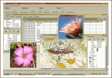
With the launch of their Android version, I became aware of CyberTracker, a free "GPS Field Data Collection System that turns your smartphone into a sophisticated tracking and monitoring device". It's a non-profit organization and they mention free software several times, but not certain that is open source software, anyone knows?

From the website: "You can use CyberTracker on a Smartphone or handheld computer to record any type of observation. CyberTracker, which requires no programming skills, allows you to customize an Application for your own data collection needs. [...] CyberTracker is the most efficient way to gather large quantities of geo-referenced data for field observations at a speed and level of detail not possible before. Observations can be entered with a simple Radio List or a Check List. Number and text fields can also be entered by means of conventional key pads or keyboards."

Plenty of screenshots here and the list of features.

Read More »

Leaflet 0.6.2 Released

A week ago the popular Leaflet version 0.6.2 was released, this comes about 5 months after version 0.5.

From the announcement: "0.6 highlights include nicer controls, lots of interaction usability improvements, many new API methods, events and options, ability to save layers as GeoJSON, much better test infrastructure and TONS of bugfixes that made Leaflet significantly more reliable. Checkout the huge detailed list of changes (120+ total!) in the changelog. The API reference was also updated to reflect all these changes. [...] On a related note, even GitHub itself is now using Leaflet for GeoJSON visualizations, along with Leaflet.markercluster & MapBox tiles!"

Another related entry is the Leaflet Plugin Authoring Guide.

Read More »

gvSIG 2.0 Novelties

During the last weeks several posts about the gvSIG Desktop novelties have been published at the gvSIG Blog. With them we try to make known all these novelties with more details. Until now, the posts that have been publisher are:

  • Scripting, exploit your gvSIG (III): Generate a polygon from a course
  • Symbols library “OSM”
  • “Google” symbols library
  • Scripting, exploit your gvSIG (II). Creating a buffer
  • Mirrors for downloads
  • Add-ons manager
  • How to create symbol libraries (II)
  • Raster data tile cache and WMTS
  • gvSIG 2.0 on 64 bits or Java 1.7 systems
  • Additional feature for managing CRS
  • gvSIG 2.0: Scripting, exploit your gvSIG
  • How to create symbol libraries (I)

In the last weeks new posts will be published, as well as the translation of the last ones in Spanish. Some of them will be related to the new add-ons that will be available for this version. They will be able to be installed from the Add-ons Manager.

Read More »

Launch of the Open Source ‘MapBox Earth’ for iOS

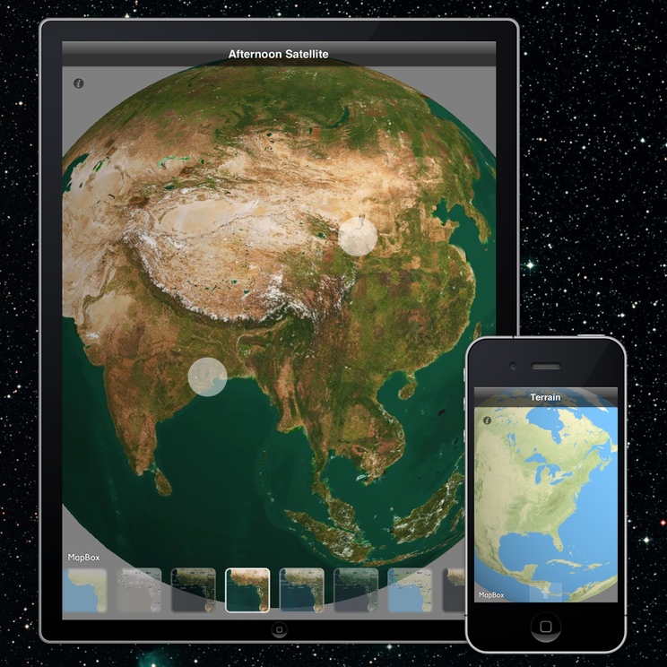
MapBox announced their open source iOS virtual globe named MapBox Earth.

From the announcement: "We just launched MapBox Earth, a free and open source iOS app that combines the power of a 3D globe with MapBox’s beautiful maps. It’s also a great starting point to build your own 3D mapping app - we’re cracking the 3D globe software market wide open by releasing the source code and building in the open. MapBox Earth is a universal app optimized for iPhone and iPad and it includes beautiful preloaded layers based off of MapBox Streets, MapBox Terrain, and MapBox Satellite. You can switch the map layer with a single tap and feel the maps right in your hands, in gorgeous and fast 3D."

We did mention some other open source virtual globes in the past months / years, such as Glob3 Mobile, the Godzi WebGL Globe, OpenWebGlobe, WebGL Earth, and there's even the Google open source 'WebGL Globe'.

Read More »

OpenStreetMap Launches iD: All-new Easy Map Editor

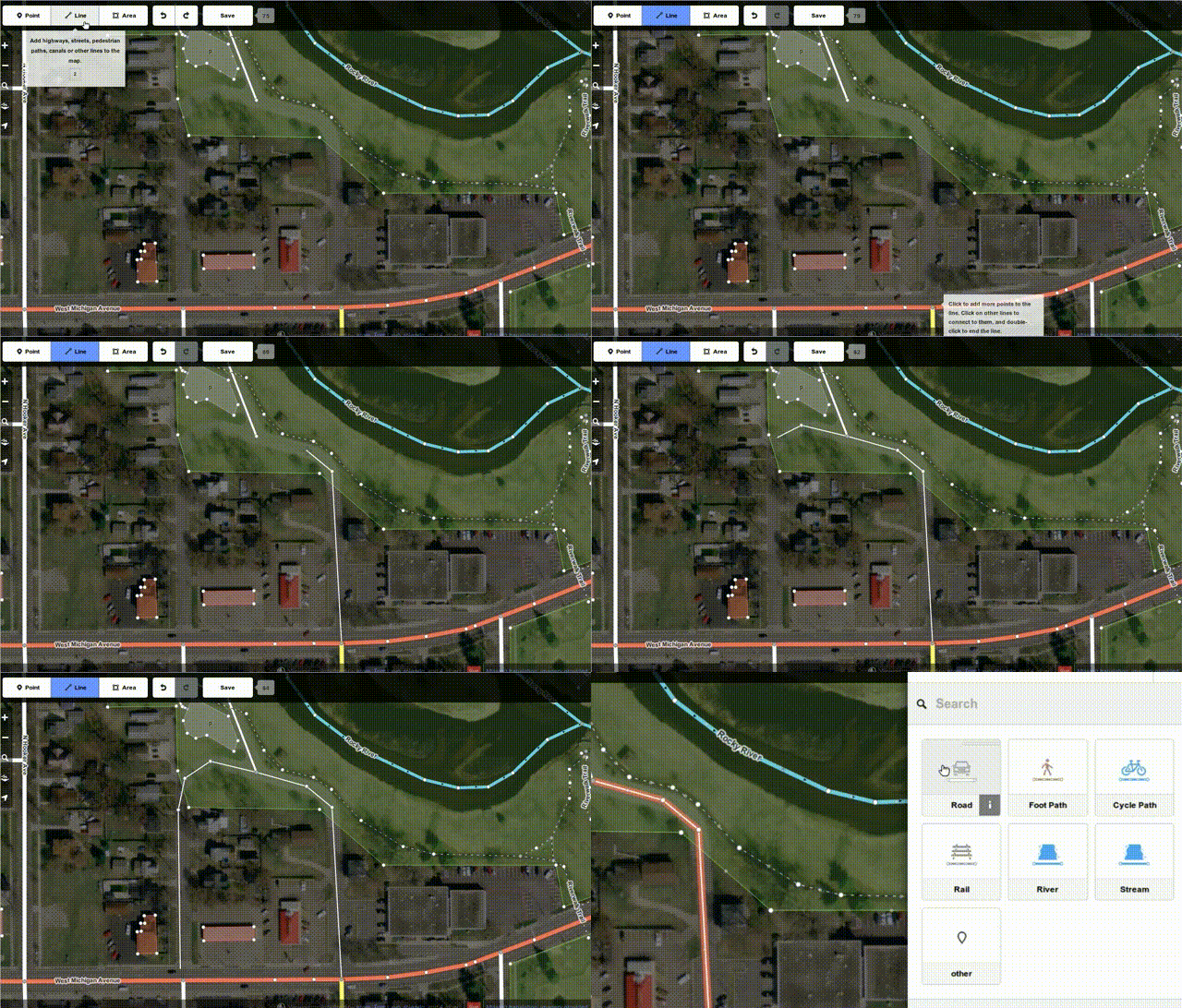
Two days ago the new open source iD editor we mentioned a few times has been officially launched, here's the official announcement OpenStreetMap launches all-new easy map editor and announces funding appeal.

From the announcement: "The new editor, codenamed ‘iD’, boasts an intuitive interface and clear walk-throughs that make editing much easier for new mappers. By lowering the barrier to contributions, we believe that more people can contribute their local knowledge to the map – the crucial factor that sets OSM apart from closed-source commercial maps. [...] The new iD editor is a pure HTML5 experience, using the cutting-edge D3 visualisation library. Behind the clear design and intuitive interface is a sophisticated back-end that automatically recommends the most popular ‘tagging’ conventions used by the OSM community."

Numerous sources discussed the new iD editor, you'll find more technical details on iD on the MapBox blog, MapBox built iD, including multiple links to media coverage. Slashdot also discussed two stories, OpenStreetMap Launches a New Easy To Use HTML5 Editor and OpenStreetMap Adds Easier Reporting of Map Problems.

Read More »

GDAL/OGR 1.10.0 Released, Now Includes Geocoding Client and Much More

I was abroad last week. I'll catch up the recent geonews in the coming days.

The open source library at the core of most open source geospatial software and numerous commercial geospatial software just got better, version 1.10.0 of GDAL/OGR has been released a week ago. The previous major version 1.9.0 was released about 16 months ago.

From the release notes: "

  • New GDAL drivers:
    • ARG: read/write support for ARG datasets (#4591)
    • CTable2: read/write support for CTable2 datum grid shift format
    • DDS: write-only support for DirectDraw Surface format (#5017)
    • IRIS: read support for products generated by the IRIS weather radar software (#4854)
    • MAP: read OziExplorer .map files (#3380)
    • MBTiles: read-only support for MBTiles rasters (needs libsqlite3)
  • New OGR drivers:
    • ElasticSearch: write-only support to write into ElasticSearch databases (needs libcurl)
    • ODS : read/write support for OpenOffice .ods (Open Document Spreadsheets) (needs libexpat)
    • OSM : read-only support for .osm / .pbf OpenStreetMap files
    • PDF: read/write support for vector/structured PDF files
    • XLSX: read/write support for MS Excel and later Open Office XML .xlsx spreadsheets (needs libexpat)
  • RFC 39: OGR Layer algebra methods
  • Add a SQL SQLite dialect :  
  • Make GDAL loadable as a SQLite3 extension (named VirtualOGR) (#4782)
  • /vsicurl_streaming/: new virtual file system handler designed to read in streaming mode dynamically generated files
  • GDAL API_PROXY mechanism to run GDAL drivers in a separate process:  
  • Significantly improved drivers : PDF, SQLite, JP2OpenJPEG
  • Add a geocoding client :  
  • Upgrade to EPSG 8.0 database"

Read More »

New final version of gvSIG available: gvSIG 2.0

The gvSIG Association announces the publishing of the gvSIG 2.0 final version [1]. The main novelty of this version is its new architecture. The way gvSIG manage the data sources has been redesigned with the objective of improving the reliability as well as the modularity, benefiting the users as well as the developers. Besides it permits an easier maintenance and evolution of the technology. Therefore it has been an investment in the future with the aim of not limiting the technological evolution and establish the bases for a quick evolution.

However this new gvSIG Desktop version includes a series of new features:

  • New installer that supports typical and custom installation.
  • Add-ons manager that allows to install new extensions and customize gvSIG from the same application.
  • Some changes in the interface of data management tools like:
    • File import/export
    • Table operations
    • New layer
  • Layer load improved
  • WMTS (Web Map Tiled Service) support
  • Raster data cache
  • Unified geoprocessing interface
  • Import symbols, making the creation of symbols libraries easy.
  • Export symbols, that allows to share complete symbols libraries with other users easily.
  • Scripting framework (languages: Jython, Groovy and Javascript).

Nevertheless it's the last version of gvSIG, it has to be taken into account that it's really a new gvSIG, so you will find that some of the gvSIG 1.12 functionalities are not included. These functionalities will be included in following and continuous updates according to their migration to the new architecture. The main functionalities that are not included are the following:

  • Georeferencing
  • Legend by proportional symbols, graduated ones, dot density, quantities by categories and by expressions.
  • Extensions: Network analysis and 3D

In the same way, there are several projects based on this new architecture that will allow to include new functionalities and improvements directly in gvSIG 2.0 in the next months.

Also it has to be taken into account that the level of stability of this new version is not as high as we would have wished, considering it a final version in order to be used by the community in an official way, and mainly to tackle the new developments on it.

For that, we encourage you to test it and send us any errors in order to fix them in the following updates. The known errors of this version can be consulted in [2].

From this version, several mirrors are now available to download the packages from gvSIG. These mirrors will be available within a few days.  

We hope you enjoy the new features of this version and you help us to improve it.


Read More »