Recent Posts

Announcing the ArcGIS Pro Beta Program

This new software was announced last week. I waited for more information and reactions before sharing it with you, but I haven't found any solid analysis or reviews so far. Esri announced the ArcGIS Pro beta program.

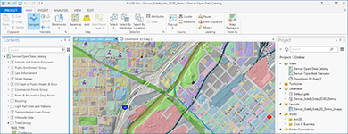
From the announcement: "Esri is pleased to announce the beta release of ArcGIS Pro, which is a new ArcGIS for Desktop application that provides many exciting features. ArcGIS Pro is designed for GIS professionals who need to visualize, edit, and perform analysis—in both 2D and 3D. All current ArcGIS for Desktop customers are invited to download ArcGIS Pro and participate in its beta program. Your work in ArcGIS Pro is organized into projects, which bring together all the resources you need to complete your GIS tasks. You can store as many maps and layouts as you need in the same project, and you can open multiple maps at once and view them side by side. You can package your projects to collaborate with others, or share your work as web maps and web layers. ArcGIS Pro can use local data, as well as content from your ArcGIS Online or Portal for ArcGIS organization. ArcGIS Pro is a 64-bit, multi-threaded application with a modern user experience that runs on the Windows platform."

FOSS4G Update: Keynotes, Travel Grants, Volunteer Discounts

Two new keynote speakers added to lineup

We are delighted to announce Sarah Novotny of NGINX and Al Shaw of ProPublica as keynote speakers for FOSS4G. They join Mike Bostock of the New York Times in this year's lineup.
 
Novotny is a technical evangelist and community manager for NGINX, founder of Blue Gecko, and is currently a program chair for O’Reilly Media’s OSCON. Shaw is a news applications developer at ProPublica and the creator of an award winning series of interactive maps documenting FEMA's response to Hurricane Sandy.
 

Travel Grant Program

 
To make sure that as many deserving people as possible can attend FOSS4G, we have created a travel grant program with funds to help cover registration, lodging, and travel costs. If you are excited about open source geospatial work but have economic barriers to attendance, we strongly encourage you to apply. Applications are due May 30th, and awardees will be notified mid-June.
 
Our travel grants are community funded; your donations help bring more of your colleagues to the conference. Consider an additional donation when you register for the conference or as a stand-alone contribution. If every attendee gave just $20, we could bring an additional 20 people to the conference.
 

Volunteer Discounts

 
We will also have a limited number of volunteer positions available; in exchange for a full day of work, volunteers will be eligible for a discounted rate of $125. Students will be given preference for these volunteer positions until July 1st. More details on the volunteer program and travel grants.
 

Important Conference Dates

 
See the full calendar for more details.
* June 15th: Early bird registration ends
* Sept 8th-9th: Workshops
* Sept 10th-12th: Main Conference
* Sept 13th: Code Sprint
 

Handy Maps Social and Routing

Bloggage update: After posting stripped French electorate data in my Cambridgeshire UK postcode area to help canvassing with my mobile from free arcgis, I added some geoprocessiong on my freemium ArcGIS Online account:

  • Update 1: see the social map created from this on a custom arcgis account
  • Update 2: see the traveling salesman problem executed on this simple example

Do let me know what you think of this! This is my first try, and I reported a few issues on time awareness and service area calculations, so stay tuned…. I keep using all means available, to learn web mapping and to share it with you.

ESA open source summer of code

We're having very few applicants this year for ESA's open source summer of code.
The deadline is May 15 midnight UTC.

ESA Summer of Code in Space (SOCIS) is a program run by the European Space Agency. It aims at offering student developers stipends to write code for various space-related open source software projects. Through SOCIS, accepted student applicants are paired with a mentor from the participating projects, thus gaining exposure to real-world software development scenarios. In turn, the participating projects are able to more easily identify and bring in new developers.

Handy Maps

Bloggage update:  With the European elections coming up, I canvass my neighbourhood for my French party. This is a classic traveling salesman problem: where are my compatriots and how can I best reach them? The electoral list I received  is confidential, so I carry around on my smartphone to canvass a map showing local compatriots in my loaded on arcgis but only seen from my login. 

In order to share the same, I strip the file I geocoded in arcgis of non-geo identifiers, and repost the data with OS Vectormap TL for the street network. Et voila! DIY maps are as easy as… 
  1. load a spreadsheet to geocode quickly&easily on arcgis
  2. read it on my smartphone to help me canvass my neighbourhood
  3. clean it and strip it of any secure info to share publicly